Nantenbach Curve
| Nantenbach curve | ||||||||||||||||||||||||||||||||||||||||||||||||||||||||||||||||||||||||||||||||||
|---|---|---|---|---|---|---|---|---|---|---|---|---|---|---|---|---|---|---|---|---|---|---|---|---|---|---|---|---|---|---|---|---|---|---|---|---|---|---|---|---|---|---|---|---|---|---|---|---|---|---|---|---|---|---|---|---|---|---|---|---|---|---|---|---|---|---|---|---|---|---|---|---|---|---|---|---|---|---|---|---|---|---|
 | ||||||||||||||||||||||||||||||||||||||||||||||||||||||||||||||||||||||||||||||||||
| Overview | ||||||||||||||||||||||||||||||||||||||||||||||||||||||||||||||||||||||||||||||||||
| Native name | Nantenbacher Kurve or Verbindungskurve Nantenbach | |||||||||||||||||||||||||||||||||||||||||||||||||||||||||||||||||||||||||||||||||
| Locale | Bavaria | |||||||||||||||||||||||||||||||||||||||||||||||||||||||||||||||||||||||||||||||||
| Line number | 5216 | |||||||||||||||||||||||||||||||||||||||||||||||||||||||||||||||||||||||||||||||||
| Technical | ||||||||||||||||||||||||||||||||||||||||||||||||||||||||||||||||||||||||||||||||||
| Line length | 11.3[1] km (7.0 mi) | |||||||||||||||||||||||||||||||||||||||||||||||||||||||||||||||||||||||||||||||||
| Track gauge | 1,435 mm (4 ft 8 1⁄2 in) standard gauge | |||||||||||||||||||||||||||||||||||||||||||||||||||||||||||||||||||||||||||||||||
| Minimum radius | 2.650 m[2] | |||||||||||||||||||||||||||||||||||||||||||||||||||||||||||||||||||||||||||||||||
| Electrification | 15 kV/16.7 Hz AC overhead catenary | |||||||||||||||||||||||||||||||||||||||||||||||||||||||||||||||||||||||||||||||||
| Operating speed | 200 km/h (124.3 mph) (maximum) | |||||||||||||||||||||||||||||||||||||||||||||||||||||||||||||||||||||||||||||||||
| ||||||||||||||||||||||||||||||||||||||||||||||||||||||||||||||||||||||||||||||||||
The Nantenbach Curve (German: Nantenbacher Kurve or Verbindungskurve Nantenbach) is the name of a connecting curve between the Main-Spessart Railway and the Hanover–Würzburg high-speed line. Coming from Aschaffenburg the line branches off towards Würzburg, about five kilometres northeast of Lohr, in the cadastral district of Nantenbach, in the community of Neuendorf. From the Main-Spessart line, the railway turns in a wide curve to the southeast to a junction at the Rohrbach operating station on the Hanover–Würzburg line.
Route
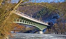
The route is 11.3 kilometres long with continuous double track, electrified, equipped with the German train protection system, Linienzugbeeinflussung and running on many engineering structures: the 694.5 metre long viaduct over the Main, followed by the 3,941 m long Schönrain Tunnel (passing under the 5,528 m long Muhlberg Tunnel on the Hanover–Würzburg line) and another three tunnels. About 60 percent of the curve (6,449 m) is four tunnels with lengths between 526 and 3941 metres. The track rises 127 m from the Nantenbach junction at 156 m above sea level to Rohrbach operating station at 283 meters above sea level on a consistent grade of 1.25%. The minimum curve radius of 2,650 m allows a speed of 200 km/h. 740 m of the line is on bridges. The track is located for its full length in the Main-Spessart nature park. The track is built largely slab track on an asphalt base.
The line is used by about 60 freight and passenger trains each day.
History
Planning for the line started in 1975 and planning approval was given in 1988.[4] Construction started in March 1990[5] and the line was put into operation in June 1994.[6]
References
- ↑ "Trassenpreis-Software 2007" (in German). Deutsche Bahn. Retrieved 26 March 2010. Distance from Nantenbach to Rohrbach is 11.331 km
- ↑ Hauptabteilung Fahrwegprojekte der Bundesbahndirektion Nürnberg, ed. (1993). Über den Fluß und durch die Berge: Die Verbindungskurve Nantenbach (Over the river and through the mountains: The Nantenbach connection curve) (in German). Nuremberg: Deutsche Bahn. pp. 2, 4, 6, 10, 12, 14.
- ↑ Eisenbahnatlas Deutschland (German railway atlas). Schweers + Wall. 2009. ISBN 978-3-89494-139-0.
- ↑ Baur, K. G. (October 1989). "Fulda−Würzburg und zurück (Fulda-Würzburg and back)". Eisenbahn-Kurier (in German) (205): 32–37. ISSN 0170-5288.
- ↑ Hörste, Jürgen; Niedt, Marcus (1991). ICE – Neue Züge für neue Strecken (ICE - New features for new lines) (in German). Zürich/Wiesbaden: Orell-Füssli-Verlag. pp. 14–19. ISBN 3-280-01994-X.
- ↑ Henn, Wolfgang; Jänsch, Eberhard (1997). "Hochgeschwindigkeitsverkehr in Deutschland − eine Zwischenbilanz (High-speed rail in Germany - interim results)". In Martinsen, Wolfram O.; Rahn, Theo. ICE – Zug der Zukunft (ICE - train of the future) (in German). Darmstadt: Hestra-Verlag. pp. 90–99.