Natchez–Vidalia Bridge
| Natchez-Vidalia Bridge | |
|---|---|
 | |
| Coordinates | 31°33′33″N 91°25′09″W / 31.55917°N 91.41917°W |
| Carries |
4 lanes of |
| Crosses | Mississippi River |
| Locale | Vidalia, Louisiana and Natchez, Mississippi |
| ID number |
21000840010001A (westbound) 21000840010001B (eastbound) |
| Characteristics | |
| Design | Twin Cantilever bridges |
| Total length |
4,205 feet (1,282 m) (westbound) 4,202 feet (1,281 m) (eastbound) |
| Width |
24 feet (7 m) (westbound) 42 feet (13 m) (eastbound) |
| Longest span | 3 848 feet (258 m) spans per bridge |
| Clearance below | 125 feet (38 m) |
| History | |
| Opened |
October 1940 (westbound) June 1988 (eastbound) |
| Statistics | |
| Daily traffic | 24,000 (2007) |
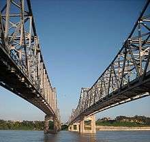
The Natchez–Vidalia Bridge are two twin cantilever bridges carrying US Routes 65, 84 and 425 across the Mississippi River between Vidalia, Louisiana and Natchez, Mississippi. It is the tallest bridge in Mississippi (although the demolished Benjamin G. Humphreys Bridge connecting Mississippi with Arkansas was taller by 5 feet, its main spans were located entirely within Arkansas).
The original bridge, built by the Works Progress Administration and completed in October 1940, has only two 8-foot lanes and lacks shoulders, and now carries all westbound traffic. The newer, eastbound bridge completed in 1988, has 11-foot lanes with inside and outside shoulders. Eastbound traffic is heavier, as that crossing goes into Natchez and connects with US Highway 61, where travelers can continue north to Vicksburg and south to Baton Rouge.[1]
See also
References
- ↑ Suzassippi (2013-04-23). "Dedicated to the People: Natchez-Vidalia Bridge". Retrieved 2016-03-02.
| Wikimedia Commons has media related to Natchez–Vidalia Bridge. |
| Crossings of the Mississippi River | ||||
|---|---|---|---|---|
| ||||