National Geospatial-Intelligence Agency
|
Seal of the U.S. National Geospatial-Intelligence Agency | |
|
Flag of the U.S. National Geospatial-Intelligence Agency | |
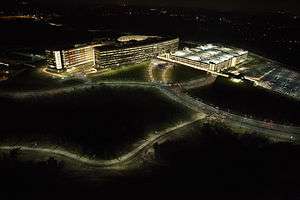 NGA Campus East is the headquarters of the agency. The building features trapezoidal windows, color-coded interior sections, and is bisected by an atrium that is large enough to hold the Statue of Liberty.[1][2][3] | |
| Agency overview | |
|---|---|
| Formed | October 1, 1996 (as the National Imagery and Mapping Agency) |
| Preceding agency |
|
| Jurisdiction | U.S. Department of Defense |
| Headquarters |
Fort Belvoir, Springfield, Virginia, U.S.[2] 38°45′12″N 77°11′49″W / 38.7532°N 77.1969°WCoordinates: 38°45′12″N 77°11′49″W / 38.7532°N 77.1969°W |
| Motto | "Know the Earth... Show the Way... Understand the World" |
| Employees | About 16,000[4] |
| Annual budget | Classified (at least $4.9 billion, as of 2013)[5] |
| Minister responsible |
|
| Agency executives |
|
| Parent agency | Department of Defense |
| Website |
www |
| Footnotes | |
| [6] | |

The National Geospatial-Intelligence Agency (NGA) is both a combat support agency, under the United States Department of Defense, and an intelligence agency of the United States Intelligence Community,[7] with the primary mission of collecting, analyzing, and distributing geospatial intelligence (GEOINT) in support of national security. NGA was known as the National Imagery and Mapping Agency (NIMA) until 2003.
NGA headquarters is located at Fort Belvoir in Springfield, Virginia, and operates major facilities in the St. Louis, Missouri area, as well as support and liaison offices worldwide. The NGA campus, at 2.3 million square feet (214,000 m2), is the third-largest government building in the Washington metropolitan area after The Pentagon and the Ronald Reagan Building.[8]
In addition to using GEOINT for U.S. military and intelligence efforts, the NGA provides assistance during natural and man-made disasters, and security planning for major events such as the Olympic Games.[9]
History
U.S. mapping and charting efforts remained relatively unchanged until World War I, when aerial photography became a major contributor to battlefield intelligence. Using stereo viewers, photo-interpreters reviewed thousands of images. Many of these were of the same target at different angles and times, giving rise to what became modern imagery analysis and mapmaking.
Engineer Reproduction Plant (ERP)
The Engineer Reproduction Plant was the Army Corps of Engineers's first attempt to centralize mapping production, printing, and distribution. It was located on the grounds of the Army War College in Washington, D.C. Previously, topographic mapping had largely been a function of individual field engineer units using field surveying techniques or copying existing or captured products. In addition, ERP assumed the "supervision and maintenance" of the War Department Map Collection, effective April 1, 1939.
Army Map Service (AMS) / U.S. Army Topographic Command (USATC)
With the advent of the Second World War aviation, field surveys began giving way to photogrammetry, photo interpretation, and geodesy. During wartime, it became increasingly possible to compile maps with minimal field work. Out of this emerged AMS, which absorbed the existing ERP in May 1942. It was located at the Dalecarlia Site (including buildings now named for John C. Frémont and Charles H. Ruth) on MacArthur Blvd., just outside Washington, D.C., in Montgomery County, Maryland, and adjacent to the Dalecarlia Reservoir. AMS was designated as an Engineer field activity, effective July 1, 1942, by General Order 22, OCE, June 19, 1942. The Army Map Service also combined many of the Army's remaining geographic intelligence organizations and the Engineer Technical Intelligence Division. AMS was redesignated the U.S. Army Topographic Command (USATC) on September 1, 1968, and continued as an independent organization until 1972, when it was merged into the new Defense Mapping Agency (DMA) and redesignated as the DMA Topographic Center (DMATC) (see below).
The agency's credit union, Constellation Federal Credit Union, was chartered during the Army Map Service era, in 1944. It has continued to serve all successive legacy agencies' employees and their families.[10]
Aeronautical Chart Plant (ACP)
After the war, as airplane capacity and range improved, the need for charts grew. The Army Air Corps established its map unit, which was renamed ACP in 1943 and was located in St. Louis, Missouri. ACP was known as the U.S. Air Force Aeronautical Chart and Information Center (ACIC) from 1952 to 1972 (See DMAAC below).
A credit union was chartered for the ACP in 1948, called Aero Chart Credit Union. It was renamed Arsenal Credit Union in 1952,[11] a nod to the St. Louis site's Civil War-era use as an arsenal.[12]
National Photographic Interpretation Center (NPIC)
Shortly before leaving office in January 1961, President Dwight D. Eisenhower authorized the creation of the National Photographic Interpretation Center, headed by Arthur C. Lundahl, combining Central Intelligence Agency (CIA), Army, Navy, and Air Force assets to solve national intelligence problems. NPIC was a component of the CIA's Directorate of Science and Technology (DDS&T) and its primary function was imagery analysis.[13]
Cuban Missile Crisis
NPIC first identified the Soviet Union's basing of missiles in Cuba in 1962. By exploiting images from U-2 overflights and film from canisters ejected by orbiting Corona satellites,[14] NPIC analysts developed the information necessary to inform U.S. policymakers and influence operations during the Cuban Missile Crisis. Their analysis garnered worldwide attention when the Kennedy Administration declassified and made public a portion of the images depicting the Soviet missiles on Cuban soil; Adlai Stevenson presented the images to the United Nations Security Council on October 25, 1962.
Defense Mapping Agency (DMA)
The Defense Mapping Agency was created on January 1, 1972, to consolidate all U.S. military mapping activities. DMA's "birth certificate", DoD Directive 5105.40, resulted from a formerly classified Presidential directive, "Organization and Management of the U.S. Foreign Intelligence Community" (November 5, 1971), which directed the consolidation of mapping functions previously dispersed among the military services.[15] DMA became operational on July 1, 1972, pursuant to General Order 3, DMA (June 16, 1972). On Oct. 1, 1996, DMA was folded into the National Imagery and Mapping Agency – which later became NGA.[16]
DMA was first headquartered at the United States Naval Observatory in Washington, D.C, then at Falls Church, Virginia. Its mostly civilian workforce was concentrated at production sites in Bethesda, Maryland, Northern Virginia, and St. Louis, Missouri. DMA was formed from the Mapping, Charting, and Geodesy Division, Defense Intelligence Agency (DIA), and from various mapping-related organizations of the military services.[17]
- DMA Hydrographic Center (DMAHC)
DMAHC was formed in 1972 when the Navy's Hydrographic Office split its two components: The charting component was attached to DMAHC, and the survey component moved to the Naval Oceanographic Office, Bay St. Louis, Mississippi, on the grounds of what is now the NASA Stennis Space Center. DMAHC was responsible for creating terrestrial maps of coastal areas worldwide and hydrographic charts for DoD. DMAHC was initially located in Suitland, Maryland, but later relocated to Brookmont (Bethesda), Maryland.
- DMA Topographic Center (DMATC)
DMATC was located in Brookmont (Bethesda), Maryland. It was responsible for creating topographic maps worldwide for DoD. DMATC's location in Bethesda, Maryland is the former site of NGA's headquarters.
- DMA Hydrographic/Topographic Center (DMAHTC)
DMAHC and DMATC eventually merged to form DMAHTC, with offices in Brookmont (Bethesda), Maryland.
- DMA Aerospace Center (DMAAC)
DMAAC originated with the U.S. Air Force's Aeronautical Chart and Information Center (ACIC) and was located in St. Louis, Missouri.
National Imagery and Mapping Agency (NIMA)


NIMA was established on October 1, 1996, by the National Defense Authorization Act for Fiscal Year 1997.[18] The creation of NIMA followed more than a year of study, debate, and planning by the defense, intelligence, and policy-making communities (as well as the Congress) and continuing consultations with customer organizations. The creation of NIMA centralized responsibility for imagery and mapping.
NIMA combined the DMA, the Central Imagery Office (CIO), and the Defense Dissemination Program Office (DDPO) in their entirety, and the mission and functions of the NPIC. Also merged into NIMA were the imagery exploitation, dissemination, and processing elements of the Defense Intelligence Agency, National Reconnaissance Office, and the Defense Airborne Reconnaissance Office.
NIMA's creation was clouded by the natural reluctance of cultures to merge and the fear that their respective missions—mapping in support of defense activities versus intelligence production, principally in support of national policymakers—would be subordinated, each to the other.[19]
NGA
With the enactment of the National Defense Authorization Act for Fiscal Year 2004 on November 24, 2003,[20] NIMA was renamed NGA to better reflect its primary mission in the area of GEOINT.[21] As a part of the 2005 Base Realignment and Closure (BRAC) process, all major Washington, D.C.-area NGA facilities, including those in Bethesda, Maryland; Reston, Virginia; and Washington, D.C., would be consolidated at a new facility at the Fort Belvoir proving grounds. This new facility, called the NGA Campus East houses several thousand people and is situated on the former Engineer Proving Ground site near Fort Belvoir. NGA facilities in St. Louis were not affected by the 2005 BRAC process.[22]
The cost of the new center, as of March 2009, was expected to be $2.4 billion. The center's campus is approximately 2,400,000 square feet (220,000 m2) and was completed in September 2011.[23]
Organization
Employees
NGA employs professionals in aeronautical analysis, cartography, geospatial analysis, imagery analysis, marine analysis, the physical sciences, geodesy, computer and telecommunication engineering, and photogrammetry, as well as those in the national security and law enforcement fields.
NIMA / NGA Directors
This table lists all Directors of the NIMA and NGA and their term of office.
| Term of Office | Director |
|---|---|
| 1996–1998 | Rear Admiral (RADM) Joseph J. (Jack) Dantone, Jr., USN, Acting Director |
| 1998–2001 | Lieutenant General (LTG) James C. King, US Army |
| 2001–2006 | Lieutenant General (Lt Gen) James R. Clapper Jr., USAF, Retired* |
| 2006–2010 | Vice Admiral (VADM) Robert B. Murrett, USN |
| 2010–2014 | Letitia Long |
| 2014–present | Robert Cardillo |
* Although General Clapper preferred the use of his military rank, he was in fact a member of the Defense Intelligence Senior Executive Service (DISES) during his term as Director of NIMA / NGA, as he had retired from active duty as the director of DIA in 1995. Clapper was the first civilian to head NIMA / NGA.
| Wikinews has related news: Letitia Long becomes first female director of a major US intelligence agency |
On February 22, 2010, Secretary of Defense Robert Gates announced that Letitia Long would become director later that year, becoming the first woman to head one of the 16 Intelligence Community component agencies. Long was at the time deputy director of the DIA.[24] Long was sworn in on August 9, 2010, as head of the NGA.[25]
Civilian activities
- 9/11 aftermath: After the September 11, 2001 attacks, NIMA partnered with the U.S. Geological Survey to survey the World Trade Center site and determine the extent of the destruction.[14]
- Olympic support: In 2002, NIMA partnered with Federal organizations to provide geospatial assistance to the 2002 Winter Olympics in Utah.[14] NGA also helped support the 2004 Summer Olympics in Athens, Greece, and the 2006 Winter Olympics in Turin, Italy.
- Space Shuttle Columbia disaster: While the Space Shuttle Columbia was in orbit during STS-107, NIMA purportedly offered to image the shuttle and its suspected damage from falling debris during takeoff. NASA declined this offer (see Space Shuttle Columbia disaster), but has since forged an interagency agreement with NGA to collect imagery for all future space shuttle flights.
- Keyhole investment: NGA contributed approximately 25% of In-Q-Tel's funding of Keyhole Inc, whose Earth-viewing software became Google Earth.[26]
- Hurricane Katrina: The NGA supported Hurricane Katrina relief efforts by "providing geospatial information about the affected areas based on imagery from commercial and U.S. government satellites, and from airborne platforms, to the Federal Emergency Management Agency (FEMA) and other government agencies.[27] NGA's Earth website is a central source of these efforts.
- Microsoft partnership: Microsoft Corp. and the NGA have signed a letter of understanding to advance the design and delivery of geospatial information applications to customers.[28] NGA will continue to use the Microsoft Virtual Earth platform (as it did for Katrina relief) to provide geospatial support for humanitarian, peacekeeping, and national-security efforts. Virtual Earth is a set of online mapping and search services that deliver imagery through an API.
- Social Software Training: Several agencies in the Intelligence community, most notably CIA and NGA, have developed training programs to provide time to integrate social software tools into analysts' daily work habits. These classes generally focus on the use of Intellipedia to capture and manage knowledge, but they also use other social software tools, such as blogs, RSS, and social bookmarking. The courses stress immersion in these tools, and instructors encourage participants to work on a specific project in Intellipedia and exposes participants to social media.[29][30][31]
- Google and GeoEye: In 2008 the NGA partnered with Google and GeoEye. Google would be allowed to use GeoEye spy satellite imagery with reduced resolution for Google Earth.[26]
- First Intelligence Agency to Open Source Software on GitHub: April 2014 NGA became the first intelligence agency to open-source software on GitHub.[32] NGA Director Letitia Long talks about NGA's GitHub initiative and the first offering, GeoQ, at the GEOINT Symposium. Her comments start at 40 minutes and 40 seconds from her GEOINT 2014 conference speech. NGA open sources software packages under their GitHub organizational account.
Controversies
NIMA / NGA has been involved in several controversies.
- India tested a nuclear weapon in 1998 that reportedly took the United States by surprise. Due to budget cuts in defense spending after the end of the Cold War (see Peace dividend), the Intelligence Community was forced to reevaluate the allocation of its limited resources.[33]
- In 1999, NIMA supposedly provided NATO war-planners with incorrect maps which did not reflect that the Chinese Embassy in Belgrade had moved locations, which some have argued was the cause of the accidental NATO Bombing of the Chinese embassy in Belgrade. The Central Intelligence Agency countered this criticism by saying this overstates the importance of the map itself in the analytic process. Maps of urban areas will be out-of-date the day after they are published, but what is important is having accurate databases.[34]
- In 2013, a digital map provided by NGA misplaced Tubbataha Reef by eight miles, leading to USS Guardian's grounding.[35] The NGA later admitted to human error.[36]
Gallery
 New Headquarters of the National Geospatial-Intelligence Agency
 New NGA headquarters' atrium
 Letitia Long, director of the NGA, 2010–2014
See also
- Cartography
- Geographic Information System (GIS)
- GEOnet Names Server
- Geospatial engineering
- Geospatial Information Officer
- GIS use in the NGA
- Imagery intelligence
- Orthophoto
- Remote sensing
- Satellite imagery
References
- ↑ BRAC side effect: Greener buildings
- 1 2 "NGA Campus East Fact Sheet" (PDF).
- ↑ Top Secret America: An alternative geography
- ↑ Frequently Asked Questions (FAQs). .nga.mil. Retrieved on July 21, 2013.
- ↑ Gellman, Barton; Greg Miller (August 29, 2013). "U.S. spy network's successes, failures and objectives detailed in 'black budget' summary". The Washington Post. Retrieved August 29, 2013.
- ↑ ESA: Different Approaches taken with respect to Geo Information Sector in Europe and the United States, esa.int
- ↑ U.S.C. Title 10, § 441
- ↑ Serbu, Jared (2011-09-27). "Geospatial intelligence HQ is now DC's 3rd largest federal office building". Federal News Radio. Retrieved 2016-03-19.
- ↑ About NGA
- ↑ "Constellation Federal Credit Union - Miscellaneous - CFCU to NCE". constellationfcu.org. Retrieved December 3, 2012.
- ↑ "Arsenal Credit Union - Arsenal Credit Union - Our Roots and Structure". Arsenalcu.org. Retrieved November 27, 2012.
- ↑ ""Solving the Mystery of the Arsenal Guns" by Randy R. McGuire". civilwarstlouis.com. Retrieved November 27, 2012.
- ↑ "Thirty ... and thriving". Central Intelligence Agency. December 1, 1991. p. 1ff. Retrieved May 30, 2010.
- 1 2 3 NGA History, nga.mil
- ↑ Nixon, Richard (November 5, 1971). "Memorandum, Subject: Organization and Management of the U.S. Foreign Intelligence Community" (PDF). gwu.edu. Retrieved August 12, 2007.
- ↑ "Defense Mapping Agency". NGA.mil.
- ↑ U.S. National Archives. "Guide to Federal Records: Records of the Defense Mapping Agency (DMA)". National Archives and Records Administration (NARA). Retrieved August 12, 2007.
- ↑ "National Defense Authorization Act for Fiscal Year 1997" (PDF). September 23, 1996. Retrieved February 10, 2008.
- ↑ Report of the Independent Commission on NIMA - December 2000, nga.mil
- ↑ "National Defense Authorization Act for Fiscal Year 2004" (PDF). November 24, 2003. Retrieved February 10, 2008., gpo.gov
- ↑ NGA: September-October 2003 State of the Agency
- ↑ New Campus East, nga.mil
- ↑ Davenport, Christian, "Projects' Costs Are Rising", Washington Post, March 31, 2009, p. B4
- ↑ "Gates names first woman to head major intel agency". FederalTimes.com. February 23, 2010. Retrieved February 25, 2010.
Letitia Long, currently the Defense Intelligence Agency's deputy director, will take over NGA this summer, Gates said.
- ↑ "Woman takes charge of major intelligence agency for the first time". CNN. August 9, 2010. Retrieved August 11, 2010.
- 1 2 "Oakland emails give another glimpse into the Google-Military-Surveillance Complex". PandoDaily.
- ↑ Geospatial Intelligence Aids Hurricane Recovery Efforts, nga.mil
- ↑ Microsoft and NGA Announce Strategic Alliance, microsoft.com
- ↑ Radio interview that highlights Intelligence Community social software training programs, Federal News Radio, 5 November 2007, Federalnewsradio.com
- ↑ Executive Spotlight Interview with Sean Dennehy, ExecutiveBiz, December 5, 2007
- ↑ Executive Spotlight Interview with Chris Rasmussen, ExecutiveBiz, October 25, 2007
- ↑ NGA releases open source code on GitHub, FierceGovernmentIT, April 07, 2014
- ↑ "Secretive map agency opens its doors", CNN.com, December 13, 2002
- ↑ DCI Statement on the Belgrade Chinese Embassy Bombing to a House Permanent Select Committee on Intelligence Open Hearing, 22 July 1999, cia.gov
- ↑ "Digital Map Error May Have Led To Minesweeper Grounding."
- ↑ "Untold Tale Behind USS Guardian Reef Grounding: NGA's Map Was Wrong By 8 Miles."
Further reading
- Ambinder, Marc (May 5, 2011). "The Little-Known Agency That Helped Kill Bin Laden". The Atlantic. Explains the NGA's capabilities.
External links
| Wikimedia Commons has media related to National Geospatial-Intelligence Agency. |
- National Geospatial-Intelligence Agency official website
- GEOnet Names Server (GNS) - Database of foreign geographic feature names. Worldwide coverage excluding the United States and Antarctica, containing approximately 3.93 million features with 5.45 million names, and their coordinates
- NGA Earth - Formerly KatrinaImagery.org (Hurricane Crisis Imagery)
- Center for Geospatial Intelligence : University of Missouri - Columbia research center focused on GeoINT
- : JP 2-03, Geospatial Intelligence Support to Joint Operations, 31 October 2012
- Commission Report on the National Imagery and Mapping Agency
- GeoIntelligence: A trade publication covering the uses of spatial technologies for national defense and homeland security by organizations such as NGA
- Ensor, David (December 13, 2002). "Secretive map agency opens its doors". CNN.
- DMA Receives Hammer Award, 26 January 1996
- Agency Provides More Than Just Maps
- The Center for Intelligence and Security Studies trains new analysts in Intelligence Analysis
|  | |||||||||||||||||||||||||||||||||||||||||
|
| ||||||||||||||||||||||||||||||||||||||||||