National Register of Historic Places listings in Fergus County, Montana
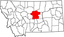
Location of Fergus County in Montana
This is a list of the National Register of Historic Places listings in Fergus County, Montana. It is intended to be a complete list of the properties and districts on the National Register of Historic Places in Fergus County, Montana, United States. The locations of National Register properties and districts for which the latitude and longitude coordinates are included below, may be seen in a map.[1]
There are 42 properties and districts listed on the National Register in the county.
- This National Park Service list is complete through NPS recent listings posted December 16, 2016.[2]
Listings county-wide
| [3] | Name on the Register | Image | Date listed[4] | Location | City or town | Description |
|---|---|---|---|---|---|---|
| 1 | Anderson House | Upload image | (#92001770) |
1015 W. Watson 47°03′32″N 109°25′54″W / 47.058889°N 109.431667°W |
Lewistown | |
| 2 | Ayers House | Upload image | (#86000061) |
316 8th Ave., S. 47°04′06″N 109°25′39″W / 47.068333°N 109.4275°W |
Lewistown | |
| 3 | Bright House | Upload image | (#92001766) |
707 W. Boulevard 47°03′50″N 109°25′56″W / 47.063889°N 109.432222°W |
Lewistown | |
| 4 | Clark-Cardwell House | Upload image | (#86000063) |
523 W. Watson 47°03′40″N 109°25′34″W / 47.061111°N 109.426111°W |
Lewistown | |
| 5 | Culver Studio | Upload image | (#80002412) |
212 5th Ave. 47°03′49″N 109°25′43″W / 47.063611°N 109.428611°W |
Lewistown | |
| 6 | Fergus County High School | _-_Fergus_County%2C_Montana.png) |
(#85001409) |
412 6th Ave., S. 47°03′37″N 109°25′33″W / 47.060278°N 109.425833°W |
Lewistown | |
| 7 | Fergus County Improvement Corporation Dormitory | Upload image | (#80002413) |
216 7th St., S. 47°03′37″N 109°25′41″W / 47.060278°N 109.428056°W |
Lewistown | |
| 8 | First Presbyterian Church | _-_Fergus_County%2C_Montana.png) |
(#86000065) |
215 5th Ave., S. 47°03′45″N 109°25′30″W / 47.0625°N 109.425°W |
Lewistown | |
| 9 | Frank Hagadone Homestead | 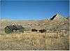 |
(#08001384) |
20 miles (32 km) north of Winifred, near Mile 97 on the Missouri River[5] 47°43′45″N 109°28′35″W / 47.7292°N 109.4764°W |
Winifred | |
| 10 | Abraham and Mary Walton Hogeland House | Upload image | (#07000465) |
620 W. Montana St. 47°03′55″N 109°25′57″W / 47.065278°N 109.4325°W |
Lewistown | |
| 11 | House at 301 Eighth Avenue, South | Upload image | (#86000066) |
301 8th Ave., S. 47°03′23″N 109°25′39″W / 47.056389°N 109.4275°W |
Lewistown | |
| 12 | House at 324 W. Corcoran | Upload image | (#92001773) |
324 W. Corcoran 47°04′07″N 109°25′52″W / 47.068611°N 109.431111°W |
Lewistown | |
| 13 | House at 618 West Janeaux | Upload image | (#86000062) |
618 W. Janeaux 47°03′44″N 109°25′35″W / 47.062222°N 109.426389°W |
Lewistown | |
| 14 | House at 805 W. Watson | Upload image | (#92001767) |
805 W. Watson 47°03′38″N 109°25′46″W / 47.060556°N 109.429444°W |
Lewistown | |
| 15 | House at 809 W. Watson | Upload image | (#92001768) |
809 W. Watson 47°03′38″N 109°25′45″W / 47.060556°N 109.429167°W |
Lewistown | |
| 16 | House at 813 W. Watson | Upload image | (#92001769) |
813 W. Watson 47°03′39″N 109°25′45″W / 47.060833°N 109.429167°W |
Lewistown | |
| 17 | Huntoon Residence | Upload image | (#85001408) |
722 W. Water 47°03′24″N 109°25′38″W / 47.056667°N 109.427222°W |
Lewistown | |
| 18 | Judith Landing Historic District | Upload image | (#75001081) |
Address Restricted |
Winifred | Extends into Chouteau County. Boundary increase on 2014-04-11. |
| 19 | Judith Place Historic District | Upload image | (#88000465) |
Roughly bounded by Main St., the alley between Hawthorne and Ridgelawn Sts., Washington St., and Oullette St. 47°04′16″N 109°25′01″W / 47.071111°N 109.416944°W |
Lewistown | |
| 20 | Lewis House | Upload image | (#92001765) |
702 W. Boulevard 47°03′52″N 109°25′56″W / 47.064444°N 109.432222°W |
Lewistown | |
| 21 | Lewistown Carnegie Library | 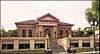 |
(#80002411) |
701 W. Main St. 47°03′41″N 109°25′47″W / 47.061389°N 109.429722°W |
Lewistown | |
| 22 | Lewistown Central Business Historic District |  |
(#85001405) |
Roughly bounded by Washington St., 1st Ave., Janeaux St., and 8th Ave. 47°03′53″N 109°25′44″W / 47.064722°N 109.428889°W |
Lewistown | |
| 23 | Lewistown Courthouse Historic District | 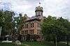 |
(#85001406) |
Roughly bounded by Washington St., 6th Ave., Main and Broadway Sts. 47°03′42″N 109°25′50″W / 47.061667°N 109.430556°W |
Lewistown | |
| 24 | Lewistown Mercantile Company | Upload image | (#86000064) |
220 E. Main 47°04′03″N 109°25′20″W / 47.0675°N 109.422222°W |
Lewistown | |
| 25 | Lewistown Satellite Airfield Historic District | Upload image | (#00000162) |
U.S. Route 87 47°02′50″N 109°27′30″W / 47.047222°N 109.458333°W |
Lewistown | |
| 26 | Lewistown Silk Stocking District | 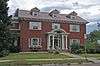 |
(#85001407) |
Roughly bounded by 2nd Ave., Boulevard and Washington Sts. and 3rd Ave. 47°03′58″N 109°25′36″W / 47.066111°N 109.426667°W |
Lewistown | |
| 27 | Masonic Temple | 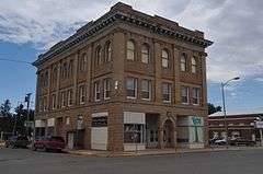 |
(#79001401) |
322 W. Broadway St. 47°03′53″N 109°25′35″W / 47.064722°N 109.426389°W |
Lewistown | |
| 28 | Mill House | Upload image | (#92001764) |
Montana Highway 466 4.5 miles (7.2 km) southeast of Lewistown, along Spring Creek 47°01′10″N 109°21′26″W / 47.019444°N 109.357222°W |
Lewistown | |
| 29 | N-Bar Ranch | Upload image | (#91000881) |
15 miles (24 km) southwest of Grass Range 46°51′16″N 108°56′19″W / 46.854444°N 108.938611°W |
Grass Range | |
| 30 | Naylor Brothers Ranch Historic District | Upload image | (#08001261) |
503 E. Dry Creek Rd.[6] 46°48′37″N 109°44′49″W / 46.8103°N 109.7469°W |
Buffalo | |
| 31 | Gus Nelson Homestead | Upload image | (#11000093) |
Missouri River, River Mile 129.4-131.1; west side of river 47°45′07″N 108°55′59″W / 47.7519°N 108.9331°W |
Cow Island vicinity | |
| 32 | Reed and Bowles Trading Post |  |
(#10000520) |
Joyland Rd.[7] 47°05′16″N 109°27′25″W / 47.0878°N 109.4569°W |
Lewistown vicinity | |
| 33 | Reed's Fort Post Office | Upload image | (#10000545) |
.1 miles (0.16 km) southwest from the junction of Brassey St. and 6th Ave. on Casino Creek Dr.[8] 47°03′30″N 109°25′27″W / 47.0583°N 109.4242°W |
Lewistown | |
| 34 | Fred Robinson Bridge | Upload image | (#12000171) |
Milepost 88, US 191, 51 miles (82 km) north of Lewistown 47°37′51″N 108°41′06″W / 47.630723°N 108.684937°W |
Lewistown vicinity | Montana's Steel Stringer and Steel Girder Bridges Multiple Property Submission; extends into Phillips County |
| 35 | Rocky Point | Upload image | (#75001082) |
30 miles (48 km) south of Landusky in the Charles M. Russell National Wildlife Refuge 47°36′23″N 108°26′41″W / 47.606389°N 108.444722°W |
Landusky | |
| 36 | St. James Episcopal Church and Parish House | Upload image | (#78001683) |
502 W. Montana St. 47°03′55″N 109°25′51″W / 47.065278°N 109.430833°W |
Lewistown | |
| 37 | St. Joseph's Hospital | Upload image | (#78001684) |
U.S. Route 87 47°04′06″N 109°25′06″W / 47.068333°N 109.418333°W |
Lewistown | |
| 38 | St. Leo's Catholic Church | _-_Fergus_County%2C_Montana.png) |
(#82003163) |
124 W. Broadway 47°03′58″N 109°25′29″W / 47.066111°N 109.424722°W |
Lewistown | |
| 39 | St. Wenceslaus Catholic Church | 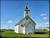 |
(#14000221) |
7724 Danvers Road 47°13′28″N 109°43′03″W / 47.2244°N 109.7175°W |
Danvers | |
| 40 | Schroeder Hospital | Upload image | (#92001771) |
502 5th Ave., S. 47°03′45″N 109°25′30″W / 47.0625°N 109.425°W |
Lewistown | |
| 41 | Stafford's Grocery | Upload image | (#16000141) |
201 Main St. 47°33′34″N 109°22′35″W / 47.559436°N 109.376467°W |
Winifred | |
| 42 | US Post Office and Federal Building-Lewistown | Upload image | (#86000684) |
204 3rd Ave., N. 47°03′55″N 109°25′34″W / 47.065278°N 109.426111°W |
Lewistown |
See also
| Wikimedia Commons has media related to National Register of Historic Places in Fergus County, Montana. |
- List of National Historic Landmarks in Montana
- National Register of Historic Places listings in Montana
References
- ↑ The latitude and longitude information provided in this table was derived originally from the National Register Information System, which has been found to be fairly accurate for about 99% of listings. For about 1% of NRIS original coordinates, experience has shown that one or both coordinates are typos or otherwise extremely far off; some corrections may have been made. A more subtle problem causes many locations to be off by up to 150 yards, depending on location in the country: most NRIS coordinates were derived from tracing out latitude and longitudes off of USGS topographical quadrant maps created under the North American Datum of 1927, which differs from the current, highly accurate WGS84 GPS system used by most on-line maps. Chicago is about right, but NRIS longitudes in Washington are higher by about 4.5 seconds, and are lower by about 2.0 seconds in Maine. Latitudes differ by about 1.0 second in Florida. Some locations in this table may have been corrected to current GPS standards.
- ↑ "National Register of Historic Places: Weekly List Actions". National Park Service, United States Department of the Interior. Retrieved on December 16, 2016.
- ↑ Numbers represent an ordering by significant words. Various colorings, defined here, differentiate National Historic Landmarks and historic districts from other NRHP buildings, structures, sites or objects.
- ↑ The eight-digit number below each date is the number assigned to each location in the National Register Information System database, which can be viewed by clicking the number.
- ↑ geocode codes derived from Google Earth and description of hike to Hagdone site on Friends of the Missouri Breaks Monument website
- ↑ Geocode coords derived from Google Maps and description of location in NRHP Registration Form.
- ↑ Geocode coordinates derived from NRHP Registration Form
- ↑ Geocode coordinates derived from NRHP Registration Form
| Topics | |
|---|---|
| Lists by states |
|
| Lists by insular areas | |
| Lists by associated states | |
| Other areas | |
| |
Municipalities and communities of Fergus County, Montana, United States | ||
|---|---|---|
| City | | |
| Towns | ||
| CDP | ||
| Other unincorporated communities | ||
| Ghost town | ||
This article is issued from Wikipedia - version of the 5/8/2016. The text is available under the Creative Commons Attribution/Share Alike but additional terms may apply for the media files.