| [3] |
Name on the Register |
Image |
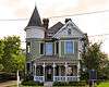
Date listed[4] |
Location |
City or town |
Description |
|---|
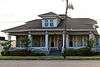
| 1 |
Beaumont Commercial District |
|
000000001978-04-14-0000April 14, 1978
(#78002959) |
Roughly bounded by Orleans, Bowie, Neches, Crockett, Laurel, Willow, Broadway, Pearl, Main, and Gilbert Sts.
30°04′55″N 94°05′56″W / 30.081944°N 94.098889°W / 30.081944; -94.098889 (Beaumont Commercial District) |
Beaumont |
|
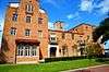
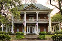
| 2 |
Beaumont Y.M.C.A. |
|
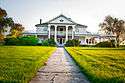
000000001979-03-30-0000March 30, 1979
(#79002985) |
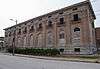
934 Calder St.
30°05′09″N 94°07′36″W / 30.085833°N 94.126667°W / 30.085833; -94.126667 (Beaumont Y.M.C.A.) |
Beaumont |
|
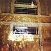
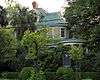
| 3 |
Holmes Duke House |
|
000000001984-10-04-0000October 4, 1984
(#84000028) |
694 Forrest St.
30°05′15″N 94°06′18″W / 30.0875°N 94.105°W / 30.0875; -94.105 (Holmes Duke House) |
Beaumont |
|
| 4 |
Eddingston Court |
|
000000002004-10-22-0000October 22, 2004
(#04001175) |
3300 Proctor St
29°53′44″N 93°54′44″W / 29.895556°N 93.912222°W / 29.895556; -93.912222 (Eddingston Court) |
Port Arthur |
|
| 5 |
First National Bank of Port Arthur |
Upload image |
000000002015-11-24-0000November 24, 2015
(#15000837) |
501 Proctor St
29°52′19″N 93°56′06″W / 29.871818°N 93.934999°W / 29.871818; -93.934999 (First National Bank of Port Arthur) |
Port Arthur |
Now houses the Port Arthur Chamber of Commerce
|
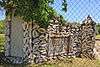
| 6 |
French Home Trading Post |
|
000000001970-10-15-0000October 15, 1970
(#70000752) |
2995 French Rd.
30°06′36″N 94°08′35″W / 30.11°N 94.143056°W / 30.11; -94.143056 (French Home Trading Post) |
Beaumont |
|
| 7 |
Gates Memorial Library |
|
000000001981-05-04-0000May 4, 1981
(#81000632) |
317 Stilwell Blvd.
29°52′42″N 93°55′38″W / 29.878333°N 93.927222°W / 29.878333; -93.927222 (Gates Memorial Library) |
Port Arthur |
|
| 8 |
Hinchee House |
|
000000001978-11-21-0000November 21, 1978
(#78002960) |
1814 Park St.
30°04′12″N 94°05′38″W / 30.07°N 94.093889°W / 30.07; -94.093889 (Hinchee House) |
Beaumont |
|
| 9 |
Idle Hours |
|
000000001978-05-22-0000May 22, 1978
(#78002961) |
1608 Orange St.
30°04′07″N 94°05′57″W / 30.068611°N 94.099167°W / 30.068611; -94.099167 (Idle Hours) |
Beaumont |
|
| 10 |
Jefferson County Courthouse |
|
000000001982-06-17-0000June 17, 1982
(#82004509) |
1149 Pearl St.
30°04′44″N 94°05′36″W / 30.078889°N 94.093333°W / 30.078889; -94.093333 (Jefferson County Courthouse) |
Beaumont |
|
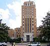
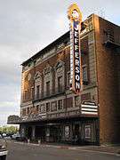
| 11 |
Jefferson Theatre |
|
000000001978-01-30-0000January 30, 1978
(#78002962) |
345 Fannin St.
30°04′54″N 94°05′52″W / 30.081667°N 94.097778°W / 30.081667; -94.097778 (Jefferson Theatre) |
Beaumont |
|
| 12 |
Lamar State College of Technology Administration Building |
Upload image |
000000002015-11-27-0000November 27, 2015
(#15000838) |
1026 Mirabeau St.
30°02′34″N 94°04′21″W / 30.042699°N 94.072382°W / 30.042699; -94.072382 (Lamar State College of Technology Administration Building) |
Beaumont |
|
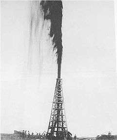
| 13 |
Lucas Gusher, Spindletop Oil Field |
|
000000001966-11-13-0000November 13, 1966
(#66000818) |
3 mi (4.8 km). S of Beaumont on Spindletop Ave.
30°01′12″N 94°04′31″W / 30.02°N 94.075278°W / 30.02; -94.075278 (Lucas Gusher, Spindletop Oil Field) |
Beaumont |
|
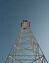
| 14 |
Marconi Tower at Port Arthur College |
|
000000002008-08-05-0000August 5, 2008
(#08000756) |
1500 Procter St.
29°52′46″N 93°55′35″W / 29.879537°N 93.926327°W / 29.879537; -93.926327 (Marconi Tower at Port Arthur College) |
Port Arthur |
|
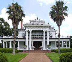
| 15 |
McFaddin House Complex |
|
000000001971-01-25-0000January 25, 1971
(#71000942) |
1906 McFaddin St.
30°05′14″N 94°06′56″W / 30.087222°N 94.115417°W / 30.087222; -94.115417 (McFaddin House Complex) |
Beaumont |
|
| 16 |
Mildred Buildings |
|
000000001978-12-01-0000December 1, 1978
(#78002963) |
1400 block of Calder Ave.
30°05′08″N 94°06′36″W / 30.085556°N 94.11°W / 30.085556; -94.11 (Mildred Buildings) |
Beaumont |
|
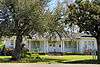
| 17 |
Pompeiian Villa |
|
000000001973-05-23-0000May 23, 1973
(#73001967) |
1953 Lakeshore Dr.
29°52′59″N 93°55′22″W / 29.883056°N 93.922778°W / 29.883056; -93.922778 (Pompeiian Villa) |
Port Arthur |
|
| 18 |
Port Arthur Federated Women's Clubhouse |
|
000000001985-07-18-0000July 18, 1985
(#85001559) |
1924 Lakeshore Dr.
29°52′54″N 93°55′22″W / 29.881667°N 93.922778°W / 29.881667; -93.922778 (Port Arthur Federated Women's Clubhouse) |
Port Arthur |
|
| 19 |
Port Arthur-Orange Bridge |
|
000000001996-10-10-0000October 10, 1996
(#96001127) |
TX 87 at the Jefferson and Orange Cnty. line
29°58′47″N 93°52′18″W / 29.979722°N 93.871667°W / 29.979722; -93.871667 (Port Arthur-Orange Bridge) |
Groves |
|
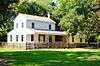
| 20 |
Rose Hill |
|
000000001979-10-31-0000October 31, 1979
(#79002986) |
100 Woodworth Blvd.
29°53′24″N 93°54′54″W / 29.89°N 93.915°W / 29.89; -93.915 (Rose Hill) |
Port Arthur |
|
| 21 |
Sanders House |
|
000000001978-12-13-0000December 13, 1978
(#78002964) |
479 Pine
30°05′10″N 94°05′53″W / 30.086111°N 94.098056°W / 30.086111; -94.098056 (Sanders House) |
Beaumont |
|
| 22 |
US Post Office and Federal Building |
|
000000001986-05-12-0000May 12, 1986
(#86001099) |
500 Austin Ave.
29°52′22″N 93°56′07″W / 29.872778°N 93.935278°W / 29.872778; -93.935278 (US Post Office and Federal Building) |
Port Arthur |
|
| 23 |
Woman's Club of Beaumont Clubhouse |
|
000000001994-08-16-0000August 16, 1994
(#94000983) |
575 Magnolia Ave.
30°05′11″N 94°06′15″W / 30.086389°N 94.104167°W / 30.086389; -94.104167 (Woman's Club of Beaumont Clubhouse) |
Beaumont |
|


.jpg)