| [3] |
Name on the Register[4] |
Image |
Date listed[5] |
Location |
City or town |
Description |
|---|
| 1 |
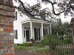
Alesia |
Upload image |
000000001983-03-14-0000March 14, 1983
(#83000514) |
108 N. Morgan St.
30°08′56″N 91°57′49″W / 30.148889°N 91.963611°W / 30.148889; -91.963611 (Alesia) |
Broussard |
|
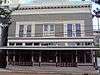
| 2 |
Bank of Scott |
Upload image |
000000002016-09-19-0000September 19, 2016
(#16000671) |
1102 St. Mary St.
30°14′11″N 92°05′41″W / 30.236451°N 92.094698°W / 30.236451; -92.094698 (Bank of Scott) |
Scott |
|
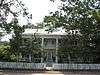
| 3 |
Billeaud House |
Upload image |
000000001983-03-14-0000March 14, 1983
(#83000515) |
303 W. Main St.
30°08′54″N 91°57′57″W / 30.148333°N 91.965833°W / 30.148333; -91.965833 (Billeaud House) |
Broussard |
|
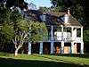
| 4 |
Martial Billeaud, Jr. House |
Upload image |
000000001983-03-14-0000March 14, 1983
(#83000516) |
118 N. Morgan St.
30°08′55″N 91°57′53″W / 30.148611°N 91.964722°W / 30.148611; -91.964722 (Martial Billeaud, Jr. House) |
Broussard |
|
| 5 |
Brandt House |
|
000000002002-06-20-0000June 20, 2002
(#02000654) |
614 Madison St.
30°13′44″N 92°01′12″W / 30.228889°N 92.02°W / 30.228889; -92.02 (Brandt House) |
Lafayette |
|
| 6 |
Valsin Broussard House |
Upload image |
000000001983-03-14-0000March 14, 1983
(#83000517) |
408 W. Main St.
30°08′58″N 91°58′03″W / 30.149444°N 91.9675°W / 30.149444; -91.9675 (Valsin Broussard House) |
Broussard |
|
| 7 |
Comeaux House |
Upload image |
000000001983-03-14-0000March 14, 1983
(#83000518) |
406 2nd St.
30°09′05″N 91°57′39″W / 30.151389°N 91.960833°W / 30.151389; -91.960833 (Comeaux House) |
Broussard |
|
| 8 |
Daigle House |
|
000000001984-06-14-0000June 14, 1984
(#84001298) |
1022 S. Washington St.
30°13′18″N 92°01′19″W / 30.221667°N 92.021944°W / 30.221667; -92.021944 (Daigle House) |
Lafayette |
|
| 9 |
Ducrest Building |
Upload image |
000000001983-03-14-0000March 14, 1983
(#83000519) |
101 W. Main St.
30°08′56″N 91°57′51″W / 30.148889°N 91.964167°W / 30.148889; -91.964167 (Ducrest Building) |
Broussard |
|
| 10 |
Dupleix House |
Upload image |
000000001984-10-04-0000October 4, 1984
(#84000013) |
106 Lafayette St.
30°05′54″N 91°59′27″W / 30.098333°N 91.990833°W / 30.098333; -91.990833 (Dupleix House) |
Youngsville |
|
| 11 |
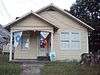
Elrose |
|
000000001984-06-14-0000June 14, 1984
(#84001305) |
217 W. University Ave.
30°13′04″N 92°01′16″W / 30.217778°N 92.021111°W / 30.217778; -92.021111 (Elrose) |
Lafayette |
|
| 12 |
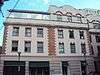
Evangeline Hotel |
Upload image |
000000001994-03-17-0000March 17, 1994
(#94000235) |
302 Jefferson St.
30°13′38″N 92°01′00″W / 30.227222°N 92.016667°W / 30.227222; -92.016667 (Evangeline Hotel) |
Lafayette |
|
| 13 |
First United Methodist Church |
Upload image |
000000001984-06-21-0000June 21, 1984
(#84001307) |
703 Lee Ave.
30°13′20″N 92°01′00″W / 30.222222°N 92.016667°W / 30.222222; -92.016667 (First United Methodist Church) |
Lafayette |
|
| 14 |
Freetown-Port Rico Historic District |
Upload image |
000000002016-02-02-0000February 2, 2016
(#15000694) |
Roughly bounded by E. University, Lee & Lucille Aves., Garfield, Coolidge & Taft Sts., Jefferson Blvd.
30°13′14″N 92°00′55″W / 30.220528°N 92.015367°W / 30.220528; -92.015367 (Freetown-Port Rico Historic District) |
Lafayette |
|
| 15 |
Gordon Hotel |
|
000000001982-06-25-0000June 25, 1982
(#82002778) |
108-110 E. Vermilion St.
30°13′25″N 92°01′07″W / 30.223611°N 92.018611°W / 30.223611; -92.018611 (Gordon Hotel) |
Lafayette |
|
| 16 |
Holy Rosary Institute |
Upload image |
000000001980-12-03-0000December 3, 1980
(#80001734) |
421 Carmel Ave.
30°14′05″N 91°59′57″W / 30.234722°N 91.999167°W / 30.234722; -91.999167 (Holy Rosary Institute) |
Lafayette |
|
| 17 |
Hope Lodge No. 145 |
|
000000001983-01-21-0000January 21, 1983
(#83000520) |
116 E. Vermilion St.
30°13′25″N 92°01′05″W / 30.223611°N 92.018056°W / 30.223611; -92.018056 (Hope Lodge No. 145) |
Lafayette |
|
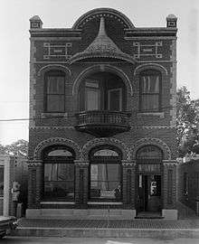
| 18 |
Janin Store |
Upload image |
000000001983-03-14-0000March 14, 1983
(#83000521) |
121 N. Morgan St.
30°09′01″N 91°57′49″W / 30.150278°N 91.963611°W / 30.150278; -91.963611 (Janin Store) |
Broussard |
|
| 19 |
Lafayette Elementary School |
Upload image |
000000001984-06-14-0000June 14, 1984
(#84001308) |
1301 W. University Ave.
30°13′28″N 92°01′42″W / 30.224444°N 92.028333°W / 30.224444; -92.028333 (Lafayette Elementary School) |
Lafayette |
|
| 20 |
Lafayette Hardware Store |
|
000000001984-06-14-0000June 14, 1984
(#84001309) |
121 W. Vermilion St.
30°13′25″N 92°01′10″W / 30.223611°N 92.019444°W / 30.223611; -92.019444 (Lafayette Hardware Store) |
Lafayette |
|
| 21 |
Alexandre Latiolais House |
Upload image |
000000001985-05-09-0000May 9, 1985
(#85000972) |
900 E. Butcher Switch Rd.
30°17′10″N 92°00′00″W / 30.286111°N 92.0°W / 30.286111; -92.0 (Alexandre Latiolais House) |
Lafayette |
|
| 22 |
Main Street Historic District |
Upload image |
000000001983-03-14-0000March 14, 1983
(#83000522) |
203-302 E. Main St.
30°08′52″N 91°57′44″W / 30.147778°N 91.962222°W / 30.147778; -91.962222 (Main Street Historic District) |
Broussard |
|
| 23 |
Sidney Martin House |
Upload image |
000000001984-11-08-0000November 8, 1984
(#84000351) |
310 Sidney Martin Rd.
30°16′43″N 92°00′44″W / 30.278611°N 92.012222°W / 30.278611; -92.012222 (Sidney Martin House) |
Lafayette |
|
| 24 |
Alexandre Mouton House |
|
000000001975-06-18-0000June 18, 1975
(#75000850) |
1122 Lafayette St.
30°13′15″N 92°01′15″W / 30.220833°N 92.020833°W / 30.220833; -92.020833 (Alexandre Mouton House) |
Lafayette |
|
| 25 |
Charles H. Mouton House |
|
000000001980-06-09-0000June 9, 1980
(#80001735) |
338 N. Sterling St.
30°13′55″N 92°00′36″W / 30.231944°N 92.01°W / 30.231944; -92.01 (Charles H. Mouton House) |
Lafayette |
|
| 26 |
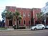
Old Guaranty Bank Building |
Upload image |
000000001984-07-12-0000July 12, 1984
(#84001311) |
500 Jefferson St.
30°13′32″N 92°01′08″W / 30.225556°N 92.018889°W / 30.225556; -92.018889 (Old Guaranty Bank Building) |
Lafayette |
|
| 27 |
Old Lafayette City Hall |
|
000000001975-06-10-0000June 10, 1975
(#75000851) |
217 W. Main St.
30°13′20″N 92°01′12″W / 30.222222°N 92.02°W / 30.222222; -92.02 (Old Lafayette City Hall) |
Lafayette |
|
| 28 |
Our Lady of the Assumption School |
|
000000002001-11-29-0000November 29, 2001
(#01001267) |
410 Michaud St.
30°19′33″N 92°02′31″W / 30.325833°N 92.041944°W / 30.325833; -92.041944 (Our Lady of the Assumption School) |
Carencro |
|
| 29 |
J. Arthur Roy House |
Upload image |
000000001984-06-14-0000June 14, 1984
(#84001314) |
1204 Johnston St.
30°13′01″N 92°01′09″W / 30.216944°N 92.019167°W / 30.216944; -92.019167 (J. Arthur Roy House) |
Lafayette |
|
| 30 |
Roy-LeBlanc House |
Upload image |
000000001983-03-14-0000March 14, 1983
(#83000523) |
105 St. Pierre St.
30°08′52″N 91°57′55″W / 30.147778°N 91.965278°W / 30.147778; -91.965278 (Roy-LeBlanc House) |
Broussard |
|
| 31 |
St. Cecilia School |
Upload image |
000000001983-03-14-0000March 14, 1983
(#83000524) |
302 W. Main St.
30°09′07″N 92°22′54″W / 30.151944°N 92.381667°W / 30.151944; -92.381667 (St. Cecilia School) |
Broussard |
|
| 32 |
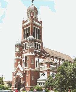
St. John's Cathedral |
|
000000001979-07-27-0000July 27, 1979
(#79001067) |
St. John St.
30°13′21″N 92°01′26″W / 30.2225°N 92.023889°W / 30.2225; -92.023889 (St. John's Cathedral) |
Lafayette |
|
| 33 |
St. Julien House |
Upload image |
000000001983-03-14-0000March 14, 1983
(#83000525) |
203 E. 2nd St.
30°09′02″N 91°57′38″W / 30.150556°N 91.960556°W / 30.150556; -91.960556 (St. Julien House) |
Broussard |
|
| 34 |
Salles House and Office |
Upload image |
000000001984-07-19-0000July 19, 1984
(#84001316) |
512 and 514 S. Buchanan St.
30°13′32″N 92°01′10″W / 30.225556°N 92.019444°W / 30.225556; -92.019444 (Salles House and Office) |
Lafayette |
|
| 35 |
Sterling Grove Historic District |
Upload image |
000000001984-07-26-0000July 26, 1984
(#84001320) |
Roughly bounded by the Evangeline Throughway and E. Simcoe, Chopin, and N. Sterling Sts.
30°13′56″N 92°00′40″W / 30.232222°N 92.011111°W / 30.232222; -92.011111 (Sterling Grove Historic District) |
Lafayette |
|
| 36 |
Vermilion Inn |
Upload image |
000000001983-07-13-0000July 13, 1983
(#83000526) |
1304 Pinhook Rd.
30°12′17″N 92°01′14″W / 30.204722°N 92.020556°W / 30.204722; -92.020556 (Vermilion Inn) |
Lafayette |
|