| [3] |
Name on the Register |
Image |
Date listed[4] |
Location |
City or town |
Description |
|---|
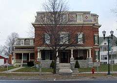
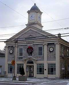
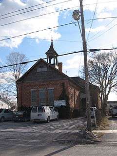
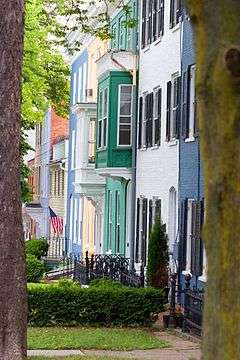
| 1 |
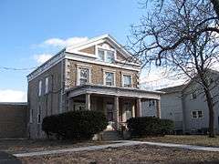
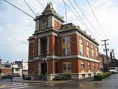
Adelaide Avenue School |
|
000000001984-04-26-0000April 26, 1984
(#84002822) |
108-116 Adelaide Ave.
42°53′01″N 77°17′10″W / 42.883611°N 77.286111°W / 42.883611; -77.286111 (Adelaide Avenue School) |
Canandaigua |
|
| 2 |
Ashcroft |
Upload image |
000000001975-11-20-0000November 20, 1975
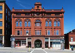
(#75001218) |
112 Jay St.
42°51′13″N 76°59′09″W / 42.853611°N 76.985833°W / 42.853611; -76.985833 (Ashcroft) |
Geneva |
|
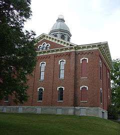
| 3 |
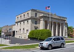
Levi Barden Cobblestone Farmhouse |
Upload image |
000000002003-07-25-0000July 25, 2003
(#03000690) |
5300 Wabash Rd.
42°46′16″N 77°02′18″W / 42.771111°N 77.038333°W / 42.771111; -77.038333 (Levi Barden Cobblestone Farmhouse) |
Seneca |
|
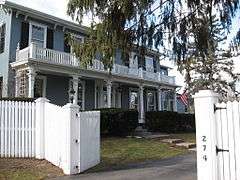
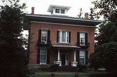
| 4 |
Thomas Barron House |
Upload image |
000000001988-10-06-0000October 6, 1988
(#88001854) |
1160 Canandaigua Rd.
42°51′45″N 77°02′01″W / 42.8625°N 77.033611°W / 42.8625; -77.033611 (Thomas Barron House) |
Seneca |
|
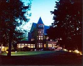
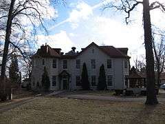
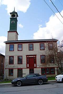
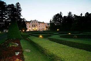
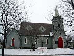
| 5 |
Belhurst Castle |
|
000000001987-01-29-0000January 29, 1987
(#86003728) |
Lochland Rd.
42°50′18″N 76°58′39″W / 42.838333°N 76.9775°W / 42.838333; -76.9775 (Belhurst Castle) |
Geneva |
House on Seneca Lake, now a restaurant and inn
|
| 6 |
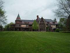
Benham House |
|
000000001984-04-26-0000April 26, 1984
(#84002823) |
280-282 S. Main St.
42°52′59″N 77°16′45″W / 42.883056°N 77.279167°W / 42.883056; -77.279167 (Benham House) |
Canandaigua |
|
| 7 |
Boughton Hill |
|
000000001966-10-15-0000October 15, 1966
(#66000559) |
Address Restricted
|
Victor |
Also known as Ganondagan State Historic Site
|
| 8 |
Brigham Hall |
|
000000001984-09-29-0000September 29, 1984
(#84002827) |
229 Bristol St.
42°52′45″N 77°17′23″W / 42.879167°N 77.289722°W / 42.879167; -77.289722 (Brigham Hall) |
Canandaigua |
|
| 9 |
Building at 426 South Main Street |
|
000000001984-04-26-0000April 26, 1984
(#84002850) |
426 S. Main St.
42°52′52″N 77°16′37″W / 42.881111°N 77.276944°W / 42.881111; -77.276944 (Building at 426 South Main Street) |
Canandaigua |
1880 brick house and contributing barn in rear are a rare older house remaining in that neighborhood
|
| 10 |
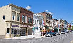
Canandaigua Historic District |
|
000000001984-04-26-0000April 26, 1984
(#84002856) |
Catherine, Dungan, Brook, Hubble & Sly Sts., portions of Park, Wood, Washington, Howell, Bemis, Main & Gibson Sts.
42°53′24″N 77°16′59″W / 42.890000°N 77.283056°W / 42.890000; -77.283056 (Canandaigua Historic District) |
Canandaigua |
Core of county seat with many intact 19th- and early 20th-century commercial buildings; boundaries increased on 000000002016-06-07-0000June 7, 2016
|
| 11 |
Canandaigua Veterans Hospital Historic District |
|
000000002012-03-27-0000March 27, 2012
(#12000161) |
400 Fort Hill Avenue
42°54′04″N 77°16′11″W / 42.901197°N 77.269734°W / 42.901197; -77.269734 (Canandaigua Veterans Hospital Historic District) |
Canandaigua |
United States Second Generation Veterans Hospitals Multiple Property Submission
|
| 12 |
Thaddeus Chapin House |
|
000000001984-04-26-0000April 26, 1984
(#84002861) |
128 Thad Chapin St.
42°52′55″N 77°17′30″W / 42.881944°N 77.291667°W / 42.881944; -77.291667 (Thaddeus Chapin House) |
Canandaigua |
|
| 13 |
Ephraim Cleveland House |
|
000000001994-02-18-0000February 18, 1994
(#94000047) |
201 N. Main St.
42°37′34″N 77°23′41″W / 42.626111°N 77.394722°W / 42.626111; -77.394722 (Ephraim Cleveland House) |
Naples |
|
| 14 |
Clifton Springs Sanitarium |
|
000000001979-04-06-0000April 6, 1979
(#79001615) |
11 and 9 E. Main St
42°57′40″N 77°08′14″W / 42.961111°N 77.137222°W / 42.961111; -77.137222 (Clifton Springs Sanitarium) |
Clifton Springs |
|
| 15 |
Clifton Springs Sanitarium Historic District |
|
000000001990-05-24-0000May 24, 1990
(#90000818) |
E. Main St. between Crane and Prospect
42°57′40″N 77°08′13″W / 42.961111°N 77.136944°W / 42.961111; -77.136944 (Clifton Springs Sanitarium Historic District) |
Clifton Springs |
|
| 16 |
Cobblestone Manor |
|
000000001984-04-26-0000April 26, 1984
(#84002862) |
495 N. Main St.
42°54′08″N 77°17′30″W / 42.902222°N 77.291667°W / 42.902222; -77.291667 (Cobblestone Manor) |
Canandaigua |
|
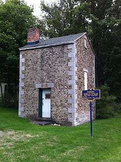
| 17 |
Cobblestone Railroad Pumphouse |
|
000000001992-05-22-0000May 22, 1992
(#92000551) |
Main St.
43°00′31″N 77°28′02″W / 43.008611°N 77.467222°W / 43.008611; -77.467222 (Cobblestone Railroad Pumphouse) |
Victor |
|
| 18 |
Jeremiah Cronkite House |
Upload image |
000000002002-02-05-0000February 5, 2002
(#01001563) |
1095 Lynaugh Rd.
42°58′59″N 77°23′51″W / 42.983056°N 77.3975°W / 42.983056; -77.3975 (Jeremiah Cronkite House) |
Victor |
|
| 19 |
John and Mary Dickson House |
Upload image |
000000002008-11-19-0000November 19, 2008
(#08001077) |
9010 Main St.
42°54′20″N 77°32′19″W / 42.905556°N 77.538611°W / 42.905556; -77.538611 (John and Mary Dickson House) |
West Bloomfield, New York |
|
| 20 |
East Bloomfield Historic District |
Upload image |
000000001989-11-13-0000November 13, 1989
(#89001947) |
Roughly Main, South, Park Sts. and NY 5
42°53′43″N 77°26′04″W / 42.895278°N 77.434444°W / 42.895278; -77.434444 (East Bloomfield Historic District) |
East Bloomfield |
|
| 21 |
Farmers and Merchants Bank |
|
000000002008-02-28-0000February 28, 2008
(#08000102) |
24-26 Linden St.
42°52′03″N 76°59′02″W / 42.8675°N 76.983889°W / 42.8675; -76.983889 (Farmers and Merchants Bank) |
Geneva |
|
| 22 |
Farmington Quaker Crossroads Historic District |
Upload image |
000000002007-04-25-0000April 25, 2007
(#07000384) |
Cty Rd. 8 at Sheldon Rd.
43°01′41″N 77°19′19″W / 43.028103°N 77.321953°W / 43.028103; -77.321953 (Farmington Quaker Crossroads Historic District) |
Farmington |
|
| 23 |
Felt Cobblestone General Store |
Upload image |
000000001992-05-22-0000May 22, 1992
(#92000553) |
6452 Victor-Manchester Rd.
42°58′28″N 77°22′53″W / 42.974444°N 77.381389°W / 42.974444; -77.381389 (Felt Cobblestone General Store) |
Victor |
|
| 24 |
First Baptist Church |
Upload image |
000000002002-10-10-0000October 10, 2002
(#02001118) |
134 N. Main St.
42°52′16″N 76°59′15″W / 42.871111°N 76.9875°W / 42.871111; -76.9875 (First Baptist Church) |
Geneva |
|
| 25 |
First Baptist Church of Phelps |
|
000000001992-05-22-0000May 22, 1992
(#92000554) |
40 Church St.
42°57′18″N 77°03′31″W / 42.955°N 77.058611°W / 42.955; -77.058611 (First Baptist Church of Phelps) |
Phelps |
|
| 26 |
Genesee Park Historic District |
Upload image |
000000002002-10-10-0000October 10, 2002
(#02001117) |
Genesee Park, Genesee Park Place, and Genesee and Lewis Sts.
42°52′16″N 76°59′02″W / 42.871111°N 76.983889°W / 42.871111; -76.983889 (Genesee Park Historic District) |
Geneva |
|
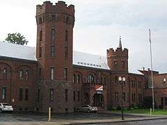
| 27 |
Geneva Armory |
|
000000001995-03-02-0000March 2, 1995
(#95000082) |
300 Main St.
42°52′01″N 76°59′07″W / 42.866944°N 76.985278°W / 42.866944; -76.985278 (Geneva Armory) |
Geneva |
|
| 28 |
Geneva Downtown Commercial Historic District |
|
000000002014-05-13-0000May 13, 2014
(#14000225) |
8-156 Castle, 16 & 20 E. Castle, 396-555 Exchange, 20-120 Seneca, 24-52 Linden & 317, 319, 325 & 329 Main Sts.
42°52′04″N 76°59′01″W / 42.8677222°N 76.9834915°W / 42.8677222; -76.9834915 (Geneva Downtown Commercial Historic District) |
Geneva |
|
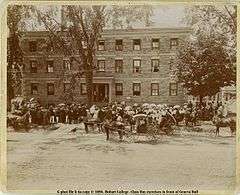
| 29 |
Geneva Hall and Trinity Hall, Hobart & William Smith College |
|
000000001973-07-16-0000July 16, 1973
(#73001241) |
S. Main St.
42°51′29″N 76°58′57″W / 42.858056°N 76.9825°W / 42.858056; -76.9825 (Geneva Hall and Trinity Hall, Hobart & William Smith College) |
Geneva |
|
| 30 |
Granger Cottage |
|
000000001984-04-26-0000April 26, 1984
(#84002865) |
60 Granger St.
42°53′51″N 77°17′07″W / 42.897621°N 77.285215°W / 42.897621; -77.285215 (Granger Cottage) |
Canandaigua |
|
| 31 |
Francis Granger House |
|
000000001984-04-26-0000April 26, 1984
(#84002867) |
426 N. Main St.
42°54′02″N 77°17′29″W / 42.900556°N 77.291389°W / 42.900556; -77.291389 (Francis Granger House) |
Canandaigua |
|
| 32 |
Harmon Cobblestone Farmhouse and Cobblestone Smokehouse |
Upload image |
000000001992-05-22-0000May 22, 1992
(#92000552) |
983 Smith Rd.
42°59′31″N 77°07′29″W / 42.991944°N 77.124722°W / 42.991944; -77.124722 (Harmon Cobblestone Farmhouse and Cobblestone Smokehouse) |
Phelps |
|
| 33 |
Dr. John Quincy Howe House |
|
000000002002-02-05-0000February 5, 2002
(#01001564) |
66 Main St.
42°57′26″N 77°03′22″W / 42.957222°N 77.056111°W / 42.957222; -77.056111 (Dr. John Quincy Howe House) |
Phelps |
|
| 34 |
William Huffman Cobblestone House |
Upload image |
000000002002-12-31-0000December 31, 2002
(#02001647) |
1064 Townline Rd.
42°59′04″N 76°58′06″W / 42.984444°N 76.968333°W / 42.984444; -76.968333 (William Huffman Cobblestone House) |
Phelps |
|
| 35 |
Knights of the Maccabees Hall |
Upload image |
000000002013-06-13-0000June 13, 2013
(#13000371) |
4270 NY 21
42°53′58″N 77°15′59″W / 42.899394°N 77.2664036°W / 42.899394; -77.2664036 (Knights of the Maccabees Hall) |
Cheshire |
|
| 36 |
Marshall House |
|
000000001984-04-26-0000April 26, 1984
(#84002869) |
274 Bristol St.
42°52′49″N 77°17′29″W / 42.880278°N 77.291389°W / 42.880278; -77.291389 (Marshall House) |
Canandaigua |
|
| 37 |
Morgan Hook and Ladder Company |
|
000000001995-06-02-0000June 2, 1995
(#95000668) |
18-20 Mill St.
42°36′55″N 77°24′13″W / 42.615278°N 77.403611°W / 42.615278; -77.403611 (Morgan Hook and Ladder Company) |
Naples |
|
| 38 |
Naples Memorial Town Hall |
|
000000001996-05-13-0000May 13, 1996
(#96000482) |
N. Main St., northeast corner of the junction of N. Main and Monier Sts.
42°37′02″N 77°24′02″W / 42.617222°N 77.400556°W / 42.617222; -77.400556 (Naples Memorial Town Hall) |
Naples |
|
| 39 |
Nester House |
|
000000001984-04-09-0000April 9, 1984
(#84002873) |
1001 Lochland Rd.
42°50′55″N 76°58′48″W / 42.848611°N 76.98°W / 42.848611; -76.98 (Nester House) |
Geneva |
|
| 40 |
North Main Street Historic District |
|
000000001973-07-20-0000July 20, 1973
(#73001239) |
Between RR tracks and Buffalo-Chapel St.
42°53′35″N 77°17′08″W / 42.893056°N 77.285556°W / 42.893056; -77.285556 (North Main Street Historic District) |
Canandaigua |
|
| 41 |
Ontario and Livingston Mutual Insurance Office |
Upload image |
000000002008-11-21-0000November 21, 2008
(#08001078) |
9018 Main St.
Coordinates missing |
West Bloomfield |
|
| 42 |
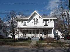
Osborne House |
|
000000001980-07-11-0000July 11, 1980
(#80002732) |
146 Maple Ave.
42°58′42″N 77°24′38″W / 42.978333°N 77.410556°W / 42.978333; -77.410556 (Osborne House) |
Victor |
|
| 43 |
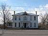
Parrott Hall |
Upload image |
000000001971-08-12-0000August 12, 1971
(#71000553) |
W. North St. between Castle St. and Preemption Rd.
42°52′36″N 77°00′30″W / 42.876667°N 77.008333°W / 42.876667; -77.008333 (Parrott Hall) |
Geneva |
|
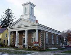
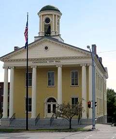
| 44 |
Phelps Town Hall |
|
000000001996-04-25-0000April 25, 1996
(#96000485) |
79 Main St.
42°57′25″N 77°03′28″W / 42.956944°N 77.057778°W / 42.956944; -77.057778 (Phelps Town Hall) |
Phelps |
|
| 45 |
Port Gibson United Methodist Church |
Upload image |
000000001996-11-29-0000November 29, 1996
(#96001387) |
2951 Greig St.
43°02′13″N 77°09′23″W / 43.036944°N 77.156389°W / 43.036944; -77.156389 (Port Gibson United Methodist Church) |
Port Gibson |
|
| 46 |
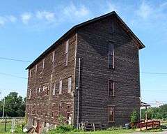
Rippey Cobblestone Farmhouse |
Upload image |
000000001992-10-06-0000October 6, 1992
(#92001051) |
1227 Leet Rd.
42°50′28″N 77°02′19″W / 42.841111°N 77.038611°W / 42.841111; -77.038611 (Rippey Cobblestone Farmhouse) |
Seneca |
|
| 47 |
St. Bridget's Roman Catholic Church Complex |
Upload image |
000000001992-08-28-0000August 28, 1992
(#92001052) |
15 Church St., between Church and Michigan Sts.
42°54′02″N 77°25′57″W / 42.900556°N 77.4325°W / 42.900556; -77.4325 (St. Bridget's Roman Catholic Church Complex) |
Bloomfield |
|
| 48 |
St. Francis de Sales Parish Complex |
Upload image |
000000002015-08-10-0000August 10, 2015
(#15000514) |
94, 110, 130 & 140 Exchange St.
Coordinates missing |
Geneva |
Complex built over 10 years beginning in 1864 reflects the rapid growth of the city's Catholic population
|
| 49 |
St. John's Episcopal Church |
Upload image |
000000001978-11-07-0000November 7, 1978
(#78001892) |
Church St.
42°57′23″N 77°03′28″W / 42.956389°N 77.057778°W / 42.956389; -77.057778 (St. John's Episcopal Church) |
Phelps |
|
| 50 |
St. Peter's Episcopal Church |
|
000000001996-11-29-0000November 29, 1996
(#96001389) |
44 Main St.
42°54′01″N 77°25′28″W / 42.900278°N 77.424444°W / 42.900278; -77.424444 (St. Peter's Episcopal Church) |
Bloomfield |
|
| 51 |
Saltonstall Street School |
|
000000001984-04-26-0000April 26, 1984
(#84002877) |
47 Saltonstall St.
42°53′03″N 77°16′36″W / 42.884167°N 77.276667°W / 42.884167; -77.276667 (Saltonstall Street School) |
Canandaigua |
|
| 52 |
Seneca Presbyterian Church |
Upload image |
000000001973-05-25-0000May 25, 1973
(#73001242) |
East of Stanley off NY 245 on Number Nine Rd.
42°48′20″N 77°03′05″W / 42.805556°N 77.051389°W / 42.805556; -77.051389 (Seneca Presbyterian Church) |
Stanley |
|
| 53 |
Smith Observatory and Dr. William R. Brooks House |
Upload image |
000000002008-04-11-0000April 11, 2008
(#08000275) |
618-620 Castle St.
42°52′20″N 77°00′11″W / 42.872097°N 77.003111°W / 42.872097; -77.003111 (Smith Observatory and Dr. William R. Brooks House) |
Geneva |
(new listing; refnum 08000275)
|
| 54 |
Smith's Opera House |
|
000000001979-10-10-0000October 10, 1979
(#02001454) |
82 Seneca St.
42°52′02″N 76°59′03″W / 42.867111°N 76.984083°W / 42.867111; -76.984083 (Smith's Opera House) |
Geneva |
|
| 55 |
Sonnenberg Gardens |
|
000000001973-09-28-0000September 28, 1973
(#73001240) |
151 Charlotte St.
42°54′00″N 77°16′21″W / 42.9°N 77.2725°W / 42.9; -77.2725 (Sonnenberg Gardens) |
Canandaigua |
|
| 56 |
South Bristol Grange Hall 1107 |
Upload image |
000000001997-12-19-0000December 19, 1997
(#97001528) |
6457 NY 64
42°42′28″N 77°22′50″W / 42.707778°N 77.380556°W / 42.707778; -77.380556 (South Bristol Grange Hall 1107) |
Bristol Springs |
|
| 57 |
South Main Street Historic District |
|
000000001974-12-31-0000December 31, 1974
(#74001286) |
Irregular pattern along S. Main St.
42°51′27″N 76°58′59″W / 42.8575°N 76.983056°W / 42.8575; -76.983056 (South Main Street Historic District) |
Geneva |
|
| 58 |
Philetus Swift House |
Upload image |
000000002005-03-15-0000March 15, 2005
(#05000159) |
866 NY 96
42°56′56″N 77°01′06″W / 42.948889°N 77.018333°W / 42.948889; -77.018333 (Philetus Swift House) |
Phelps |
|
| 59 |
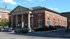
US Post Office-Canandaigua |
|
000000001988-11-17-0000November 17, 1988
(#88002465) |
28 N. Main St.
42°53′18″N 77°16′57″W / 42.888333°N 77.2825°W / 42.888333; -77.2825 (US Post Office-Canandaigua) |
Canandaigua |
Neoclassical structure completed in 1910 with front facade modeled after Erechtheion on the Acropolis in Athens. One of only three post offices in the state designed by private architects under the Tarsney Act.
|
| 60 |
US Post Office-Geneva |
|
000000001989-05-11-0000May 11, 1989
(#88002523) |
67 Castle St.
42°52′03″N 76°59′07″W / 42.8675°N 76.985278°W / 42.8675; -76.985278 (US Post Office-Geneva) |
Geneva |
|
| 61 |
Valentown Hall |
|
000000001997-05-09-0000May 9, 1997
(#97000425) |
Jct. of High St. and Valentown Rd.
43°01′34″N 77°26′09″W / 43.026111°N 77.435833°W / 43.026111; -77.435833 (Valentown Hall) |
Victor |
|
| 62 |
Oliver Warner Farmstead |
Upload image |
000000001988-11-17-0000November 17, 1988
(#88002189) |
NY 88
42°54′51″N 77°07′51″W / 42.914167°N 77.130833°W / 42.914167; -77.130833 (Oliver Warner Farmstead) |
Clifton Springs |
|
| 63 |
Washington Street Cemetery |
Upload image |
000000002002-06-04-0000June 4, 2002
(#02000616) |
Washington St.
42°51′44″N 76°59′27″W / 42.862222°N 76.990833°W / 42.862222; -76.990833 (Washington Street Cemetery) |
Geneva |
|
| 64 |
George and Addison Wheeler House |
Upload image |
000000002005-03-15-0000March 15, 2005
(#05000168) |
6353 Grimble Rd.
42°51′33″N 77°22′22″W / 42.859167°N 77.372778°W / 42.859167; -77.372778 (George and Addison Wheeler House) |
East Bloomfield |
|
| 65 |
Wilder Cemetery |
Upload image |
000000002003-03-23-0000March 23, 2003
(#03000130) |
NY 64
42°44′08″N 77°23′53″W / 42.735556°N 77.398056°W / 42.735556; -77.398056 (Wilder Cemetery) |
S. Bristol |
|
| 66 |
Woodlawn Cemetery |
Upload image |
000000002014-11-12-0000November 12, 2014
(#14000914) |
130 N. Pearl St.
42°53′18″N 77°17′56″W / 42.888333°N 77.298889°W / 42.888333; -77.298889 (Woodlawn Cemetery) |
Canandaigua |
Last resting place of many important early residents, Woodlawn shows the evolution from a churchyard cemetery to a rural one |