| [3] |
Name on the Register |
Image |
Date listed[4] |
Location |
City or town |
Description |
|---|
| 1 |
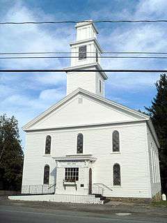
All Saints Chapel and Morris Family Burial Ground |
Upload image |
000000001997-11-24-0000November 24, 1997
(#97001455) |
State Route 51, 3 mi (4.8 km) south of Morris
42°30′33″N 75°17′19″W / 42.509167°N 75.288611°W / 42.509167; -75.288611 (All Saints Chapel and Morris Family Burial Ground) |
Morris |
|
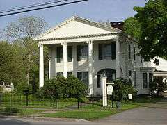
| 2 |
Baker Octagon Barn |
Upload image |
000000001984-09-29-0000September 29, 1984
(#84002887) |
State Route 28
42°49′25″N 75°00′56″W / 42.823611°N 75.015556°W / 42.823611; -75.015556 (Baker Octagon Barn) |
Richfield Springs |
|
| 3 |
Bassett Family House |
Upload image |
000000002004-08-11-0000August 11, 2004
(#04000823) |
2399 Main St.
42°34′49″N 75°03′31″W / 42.580278°N 75.058611°W / 42.580278; -75.058611 (Bassett Family House) |
Mt. Vision |
|
| 4 |
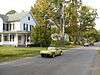
Beardslee Farm |
Upload image |
000000002000-06-30-0000June 30, 2000
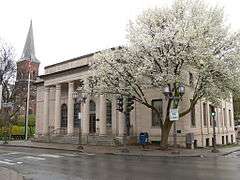
(#00000748) |
State Route 80 at Cty Rd. 18
42°37′34″N 75°19′14″W / 42.626111°N 75.320556°W / 42.626111; -75.320556 (Beardslee Farm) |
Pittsfield |
|
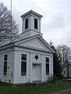
| 5 |
Bresee Hall |
|
000000001984-04-12-0000April 12, 1984
(#84002892) |
Hardwick Dr.
42°27′31″N 75°04′20″W / 42.458611°N 75.072222°W / 42.458611; -75.072222 (Bresee Hall) |
Oneonta |
|
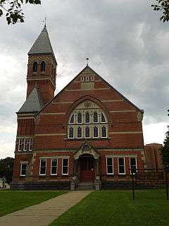
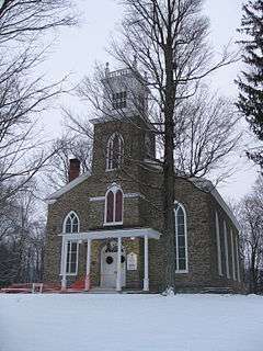
| 6 |
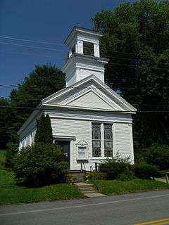
Chapin Memorial Church |
|
000000002002-09-12-0000September 12, 2002
(#02001049) |
12 Ford Ave.
42°42′24″N 74°58′36″W / 42.706667°N 74.976667°W / 42.706667; -74.976667 (Chapin Memorial Church) |
Oneonta |
|
| 7 |
Cherry Valley Village Historic District |
|
000000001988-04-28-0000April 28, 1988
(#88000472) |
Roughly bounded by Alden St. and Montgomery St., Maple Ave. and Elm St., and Main St.
42°47′48″N 74°45′09″W / 42.796667°N 74.7525°W / 42.796667; -74.7525 (Cherry Valley Village Historic District) |
Cherry Valley |
Boundary increase of 9,105 acres (36.85 km2) added as Lindesay Patent Rural Historic District in 1995 (NRHP Reference#: 95001024).
|
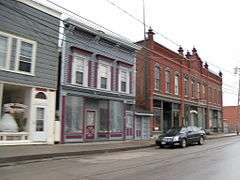
| 8 |
Church Street Historic District |
Upload image |
000000001997-06-04-0000June 4, 1997
(#97000532) |
Roughly bounded by Church, Sylvan, Gould, and Warren Sts.
42°51′21″N 74°59′02″W / 42.855833°N 74.983889°W / 42.855833; -74.983889 (Church Street Historic District) |
Richfield Springs |
|
| 9 |
Cooperstown Historic District |
|
000000001980-11-18-0000November 18, 1980
(#80002742) |
State Route 28, State Route 80, and Main St.
42°42′07″N 74°55′32″W / 42.701944°N 74.925556°W / 42.701944; -74.925556 (Cooperstown Historic District) |
Cooperstown |
Boundary increase to include Fenimore Farm Stone Agricultural Buildings in 1997 (NRHP Reference#: 97000937).
|
| 10 |
The Cornfield |
Upload image |
000000002002-09-12-0000September 12, 2002
(#02001047) |
655 Cty Rd. 26
42°27′21″N 75°03′42″W / 42.455833°N 75.061667°W / 42.455833; -75.061667 (The Cornfield) |
Fly Creek |
|
| 11 |
East Main Street Historic District |
|
000000001995-11-07-0000November 7, 1995
(#95001282) |
Roughly, E. Main St. from Church St. to the Richfield Springs reservoirs
42°51′08″N 74°58′33″W / 42.852164°N 74.975903°W / 42.852164; -74.975903 (East Main Street Historic District) |
Richfield Springs |
|
| 12 |
East Springfield Union School |
Upload image |
000000001996-04-26-0000April 26, 1996
(#96000483) |
Approximately 0.5 mi (0.80 km) east of the junction of US 20 and Co. Rd. 31
42°49′49″N 74°48′45″W / 42.830278°N 74.8125°W / 42.830278; -74.8125 (East Springfield Union School) |
East Springfield |
|
| 13 |
Fairchild Mansion |
|
000000001974-02-12-0000February 12, 1974
(#74001294) |
318 Main St.
42°27′21″N 75°03′34″W / 42.455833°N 75.059444°W / 42.455833; -75.059444 (Fairchild Mansion) |
Oneonta |
|
| 14 |
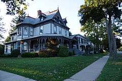
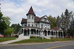
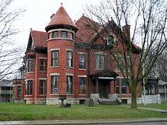
Warren Ferris House |
Upload image |
000000002016-03-08-0000March 8, 2016
(#16000063) |
7637 NY 80
Coordinates missing |
Springfield Center |
Exemplary 1894 Queen Anne house by local builder
|
| 15 |
Fly Creek Grange No. 844 |
Upload image |
000000002004-02-25-0000February 25, 2004
(#04000097) |
208 Cemetery Rd.
42°43′00″N 74°59′02″W / 42.716667°N 74.983889°W / 42.716667; -74.983889 (Fly Creek Grange No. 844) |
Fly Creek |
|
| 16 |
Fly Creek Historic District |
|
000000002006-11-08-0000November 8, 2006
(#06001004) |
State Route 28, State Route 80, County Road 26, Cemetery Rd., Goose St. Allison Rd., and Bissell Rd.
42°43′11″N 74°58′38″W / 42.719722°N 74.977222°W / 42.719722; -74.977222 (Fly Creek Historic District) |
Fly Creek |
|
| 17 |
Fly Creek Methodist Church |
|
000000001996-08-08-0000August 8, 1996
(#96000859) |
Co. Rt. 26, north of the junction with State Route 28
42°43′09″N 74°58′59″W / 42.719167°N 74.983056°W / 42.719167; -74.983056 (Fly Creek Methodist Church) |
Fly Creek |
|
| 18 |
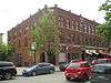
Ford Block |
|
000000001984-09-07-0000September 7, 1984
(#84002893) |
188-202 Main St.
42°27′14″N 75°03′43″W / 42.453889°N 75.061944°W / 42.453889; -75.061944 (Ford Block) |
Oneonta |
|
| 19 |
Fortin Site |
|
000000001980-11-28-0000November 28, 1980
(#80002743) |
Address Restricted
|
Oneonta |
|
| 20 |
Gilbertsville Historic District |
Upload image |
000000001974-05-17-0000May 17, 1974
(and 82001232 #74001293 and 82001232) |
Originally roughly bounded by Marion Ave., Cliff and Green Sts., Grover and Sylvan Sts.; later extended to approximate village borders
42°28′16″N 75°19′38″W / 42.471111°N 75.327222°W / 42.471111; -75.327222 (Gilbertsville Historic District) |
Gilbertsville |
Boundary increase in 1982 (NRHP Reference#: 82001232).
|
| 21 |
Gilbertsville Water Works |
Upload image |
000000002011-05-18-0000May 18, 2011
(#11000290) |
Reservoir Rd.
42°29′37″N 75°23′23″W / 42.4935145°N 75.3898316°W / 42.4935145; -75.3898316 (Gilbertsville Water Works) |
Gilbertsville vicinity |
|
| 22 |
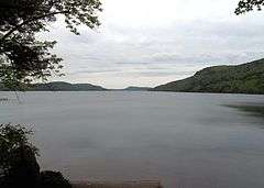
Glimmerglass Historic District |
|
000000001999-09-24-0000September 24, 1999
(#99001136) |
Otsego Lake and Environs
42°45′20″N 74°54′24″W / 42.755556°N 74.906667°W / 42.755556; -74.906667 (Glimmerglass Historic District) |
Cooperstown |
|
| 23 |
Hartwick Historic District |
|
000000002013-08-20-0000August 20, 2013
(#13000610) |
Roughly along New York State Route 205, County Road 11, and Weeks Road
42°39′35″N 75°03′03″W / 42.659701°N 75.050924°W / 42.659701; -75.050924 (Hartwick Historic District) |
Hartwick |
|
| 24 |
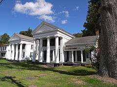
Hyde Hall |
|
000000001971-10-07-0000October 7, 1971
(#71000555) |
South of Springfield Center in Glimmerglass State Park
42°47′38″N 74°52′25″W / 42.793889°N 74.873611°W / 42.793889; -74.873611 (Hyde Hall) |
Springfield Center |
|
| 25 |
Hyde Hall Covered Bridge |
|
000000001998-12-17-0000December 17, 1998
(#98001539) |
East Lake Rd., over Shadow Brook
42°47′25″N 74°51′50″W / 42.790278°N 74.863889°W / 42.790278; -74.863889 (Hyde Hall Covered Bridge) |
East Springfield |
|
| 26 |
Kenyon Residences |
|
000000002004-02-26-0000February 26, 2004
(#04000093) |
60 and 62 Main St.
42°34′45″N 75°03′30″W / 42.579167°N 75.058333°W / 42.579167; -75.058333 (Kenyon Residences) |
Mt. Vision |
|
| 27 |
Lunn-Musser Octagon Barn |
Upload image |
000000001984-09-29-0000September 29, 1984
(#84002897) |
South of Garrattsville
42°37′39″N 75°09′26″W / 42.6275°N 75.157222°W / 42.6275; -75.157222 (Lunn-Musser Octagon Barn) |
Garrattsville |
|
| 28 |
Major's Inn and Gilbert Block |
|
000000001973-04-11-0000April 11, 1973
(#73001249) |
Both sides of Commercial St. near State Route 51
42°28′17″N 75°19′39″W / 42.471389°N 75.3275°W / 42.471389; -75.3275 (Major's Inn and Gilbert Block) |
Gilbertsville |
|
| 29 |
Andrew Mann Inn |
Upload image |
000000001980-01-10-0000January 10, 1980
(#80002747) |
33 Riverside Rd.
42°19′14″N 75°23′28″W / 42.320556°N 75.391111°W / 42.320556; -75.391111 (Andrew Mann Inn) |
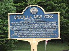
Unadilla |
|
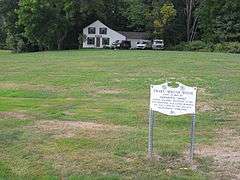
| 30 |
Mathewson–Bice Farmhouse and Mathewson Family Cemetery |
Upload image |
000000002013-05-28-0000May 28, 2013
(#13000331) |
204 Bice Rd.
42°41′38″N 74°59′03″W / 42.6939459°N 74.9840307°W / 42.6939459; -74.9840307 (Mathewson–Bice Farmhouse and Mathewson Family Cemetery) |
Cooperstown vicinity |
Late 18th-century farmhouse's design reflects owners' New England origins; family cemetery dates to 1813.
|
| 31 |
Middlefield District No. 1 School |
Upload image |
000000001987-08-13-0000August 13, 1987
(#87001363) |
CR 35
42°41′23″N 74°49′46″W / 42.689722°N 74.829444°W / 42.689722; -74.829444 (Middlefield District No. 1 School) |
Cooperstown |
|
| 32 |
Middlefield Hamlet Historic District |
|
000000001985-07-11-0000July 11, 1985
(#85001523) |
CR 35, Rezen, Whiteman, and Long Patent Rds.
42°41′14″N 74°50′29″W / 42.687222°N 74.841389°W / 42.687222; -74.841389 (Middlefield Hamlet Historic District) |
Middlefield |
|
| 33 |
Morris-Lull Farm |
Upload image |
000000002005-12-07-0000December 7, 2005
(#05001389) |
133 Peet Rd.
42°31′24″N 75°14′57″W / 42.523333°N 75.249167°W / 42.523333; -75.249167 (Morris-Lull Farm) |
Morris |
|
| 34 |
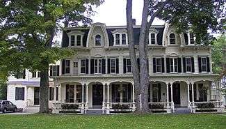
Morris Village Historic District |
Upload image |
000000002013-02-20-0000February 20, 2013
(#13000031) |
Main, Lake, Broad, Grove & Church,
42°32′55″N 75°14′43″W / 42.548749°N 75.245215°W / 42.548749; -75.245215 (Morris Village Historic District) |
Morris |
Intact core of 19th-century village settled by refugees from Revolutionary France
|
| 35 |
Municipal Building |
|
000000001982-10-29-0000October 29, 1982
(#82001233) |
238-242 Main St.
42°27′16″N 75°03′41″W / 42.454444°N 75.061389°W / 42.454444; -75.061389 (Municipal Building) |
Oneonta |
|
| 36 |
Benjamin D. North House |
Upload image |
000000001985-07-11-0000July 11, 1985
(#85001499) |
State Route 166, The Plank Rd.
42°42′12″N 74°50′08″W / 42.703333°N 74.835556°W / 42.703333; -74.835556 (Benjamin D. North House) |
Middlefield |
|
| 37 |
Old Hartwick Village Cemetery |
Upload image |
000000002013-08-20-0000August 20, 2013
(#13000611) |
2862 County Road 11
42°39′34″N 75°03′13″W / 42.659340°N 75.053502°W / 42.659340; -75.053502 (Old Hartwick Village Cemetery) |
Hartwick vicinity |
|
| 38 |
Old Post Office |
|
000000001978-11-17-0000November 17, 1978
(#78001895) |
Main St.
42°27′17″N 75°03′38″W / 42.454722°N 75.060556°W / 42.454722; -75.060556 (Old Post Office) |
Oneonta |
|
| 39 |
Oneonta Armory |
|
000000001995-03-02-0000March 2, 1995
(#95000078) |
4 Academy St.
42°27′03″N 75°03′56″W / 42.450833°N 75.065556°W / 42.450833; -75.065556 (Oneonta Armory) |
Oneonta |
|
| 40 |
Oneonta Downtown Historic District |
|
000000002003-12-04-0000December 4, 2003
(#03001245) |
Main, Chestnut, Dietz, Market, Elm, Water, Wall, S. Main Sts.
42°27′15″N 75°03′44″W / 42.454167°N 75.062222°W / 42.454167; -75.062222 (Oneonta Downtown Historic District) |
Oneonta |
|
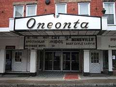
| 41 |
Oneonta Theatre |
|
000000002002-05-22-0000May 22, 2002
(#02000555) |
47 Chestnut St.
42°27′09″N 75°04′23″W / 42.4525°N 75.073056°W / 42.4525; -75.073056 (Oneonta Theatre) |
Oneonta |
|
| 42 |
Otsdawa Baptist Church |
Upload image |
000000002002-03-06-0000March 6, 2002
(#02000143) |
Cty Rd. 8
42°29′11″N 75°10′25″W / 42.486389°N 75.173611°W / 42.486389; -75.173611 (Otsdawa Baptist Church) |
Otsdawa |
|
| 43 |
Otsdawa Creek Site |
|
000000001980-07-22-0000July 22, 1980
(#80002746) |
Address Restricted
|
Otego |
|
| 44 |
Otsego County Courthouse |
|
000000001972-06-20-0000June 20, 1972
(#72000902) |
193 Main St.
42°42′03″N 74°55′48″W / 42.700833°N 74.93°W / 42.700833; -74.93 (Otsego County Courthouse) |
Cooperstown |
|
| 45 |
Roseboom Historic District |
|
000000001998-11-19-0000November 19, 1998
(#98001394) |
Roughly along State Route 166, State Route 165, Beaver, John Deer and Gage Rds.
42°44′21″N 74°46′16″W / 42.739167°N 74.771111°W / 42.739167; -74.771111 (Roseboom Historic District) |
Roseboom |
|
| 46 |
Russ-Johnsen Site |
|
000000001980-07-22-0000July 22, 1980
(#80002748) |
Address Restricted
|
Unadilla |
|
| 47 |
St. Mary's Episcopal Church Complex |
Upload image |
000000002015-03-17-0000March 17, 2015
(#15000094) |
7690 NY 80
42°49′45″N 74°52′44″W / 42.829203°N 74.8788892°W / 42.829203; -74.8788892 (St. Mary's Episcopal Church Complex) |
Springfield Center |
Fin de siècle church buildings in unusual combination of Shingle and Gothic Revival styles.
|
| 48 |
South Worcester Historic District |
|
000000001992-11-05-0000November 5, 1992
(#92001563) |
Junction of County Route 40 and County Route 39 and west along Route 40
42°31′01″N 74°45′25″W / 42.516944°N 74.756944°W / 42.516944; -74.756944 (South Worcester Historic District) |
South Worcester |
|
| 49 |
Springfield Center Elementary School |
Upload image |
000000002011-08-24-0000August 24, 2011
(#11000601) |
129 County Road 29A
42°49′56″N 74°51′46″W / 42.832222°N 74.862778°W / 42.832222; -74.862778 (Springfield Center Elementary School) |
Springfield Center |
|
| 50 |
Stonehouse Farm |
Upload image |
000000001980-11-19-0000November 19, 1980
(#80002744) |
East of Oneonta on State Route 7
42°28′14″N 75°00′08″W / 42.470556°N 75.002222°W / 42.470556; -75.002222 (Stonehouse Farm) |
Oneonta |
|
| 51 |
Sunnyside |
Upload image |
000000001988-03-10-0000March 10, 1988
(#88000211) |
72 E. Main St.
42°51′07″N 74°58′42″W / 42.851944°N 74.978333°W / 42.851944; -74.978333 (Sunnyside) |
Richfield Springs |
|
| 52 |
Swart-Wilcox House |
|
000000001990-05-24-0000May 24, 1990
(#90000817) |
Junction of Wilcox Ave. and Henry St.
42°26′38″N 75°04′15″W / 42.443889°N 75.070833°W / 42.443889; -75.070833 (Swart-Wilcox House) |
Oneonta |
|
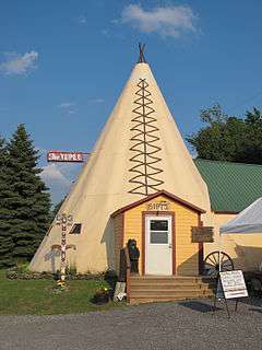
| 53 |
The Tepee |
|
000000002011-08-18-0000August 18, 2011
(#11000543) |
7632 US 20
42°48′28″N 74°41′04″W / 42.807778°N 74.684444°W / 42.807778; -74.684444 (The Tepee) |
Cherry Valley vicinity |
|
| 54 |
Tianderah |
Upload image |
000000001978-11-02-0000November 2, 1978
(#78001894) |
Off State Route 51
42°27′50″N 75°18′54″W / 42.463889°N 75.315°W / 42.463889; -75.315 (Tianderah) |
Gilbertsville |
|
| 55 |
Tunnicliff-Jordan House |
Upload image |
000000002010-09-24-0000September 24, 2010
(#10000796) |
68–72 Main Street
42°51′09″N 74°58′38″W / 42.8525°N 74.977222°W / 42.8525; -74.977222 (Tunnicliff-Jordan House) |
Richfield Springs |
|
| 56 |
Twentieth Century Steam Riding Gallery No. 409 |
Upload image |
000000001998-01-16-0000January 16, 1998
(#97001618) |
Race St.
42°32′48″N 74°49′37″W / 42.546667°N 74.826944°W / 42.546667; -74.826944 (Twentieth Century Steam Riding Gallery No. 409) |
Schenevus |
|
| 57 |
Unadilla Forks School |
Upload image |
000000001998-08-28-0000August 28, 1998
(#98001117) |
113 State Route 18A
42°50′35″N 75°14′13″W / 42.843056°N 75.236944°W / 42.843056; -75.236944 (Unadilla Forks School) |
Unadilla Forks |
|
| 58 |
Unadilla Village Historic District |
|
000000001992-09-04-0000September 4, 1992
(#92001079) |
Roughly, Main St. from Hopkins St. to Butternut Rd. and Bridge St. from Main to Watson St.
42°19′24″N 75°18′32″W / 42.323333°N 75.308889°W / 42.323333; -75.308889 (Unadilla Village Historic District) |
Unadilla |
|
| 59 |
Unadilla Waterworks |
Upload image |
000000001992-09-04-0000September 4, 1992
(#92001080) |
Junction of Kilkenny Rd. and Clifton St. and junction of Martin Brook Rd. and Rod & Gun Club Rd.
42°20′22″N 75°19′03″W / 42.339444°N 75.3175°W / 42.339444; -75.3175 (Unadilla Waterworks) |
Unadilla |
|
| 60 |
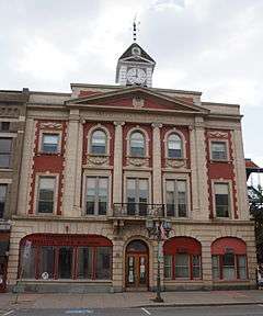
US Post Office-Cooperstown |
|
000000001988-11-17-0000November 17, 1988
(#88002473) |
28-40 Main St.
42°42′01″N 74°55′24″W / 42.700278°N 74.923333°W / 42.700278; -74.923333 (US Post Office-Cooperstown) |
Cooperstown |
|
| 61 |
US Post Office-Richfield Springs |
|
000000001989-05-11-0000May 11, 1989
(#88002422) |
152 Main St.[5]
42°51′11″N 74°59′04″W / 42.8531°N 74.9844°W / 42.8531; -74.9844 (US Post Office-Richfield Springs) |
Richfield Springs |
|
| 62 |
Lemuel F. Vibber House |
Upload image |
000000002016-06-21-0000June 21, 2016
(#16000393) |
02 Butternut Rd.
Coordinates missing |
Richfield vicinity |
Early 19th-century residence is only remnant of early industrial hamlet of Federal Corner
|
| 63 |
Walnut Street Historic District |
|
000000001980-07-30-0000July 30, 1980
(#80002745) |
Ford Ave., Walnut, Dietz, Elm and Maple Sts.
42°27′25″N 75°03′42″W / 42.456944°N 75.061667°W / 42.456944; -75.061667 (Walnut Street Historic District) |
Oneonta |
|
| 64 |
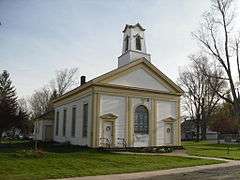
West Burlington Memorial Church |
Upload image |
000000002001-01-16-0000January 16, 2001
(#00001661) |
State Route 80
42°42′25″N 75°11′16″W / 42.706944°N 75.187778°W / 42.706944; -75.187778 (West Burlington Memorial Church) |
West Burlington |
|
| 65 |
West Main Street-West James Street Historic District |
|
000000001994-03-17-0000March 17, 1994
(#94000257) |
Roughly, along W. Main, W. James, Elm and Center Sts. and Taylor Ave.
42°51′12″N 74°59′19″W / 42.853333°N 74.988611°W / 42.853333; -74.988611 (West Main Street-West James Street Historic District) |
Richfield Springs |
|
| 66 |
The White House |
Upload image |
000000002012-09-04-0000September 4, 2012
(#12000598) |
108 White House Rd.
42°41′14″N 75°03′18″W / 42.687183°N 75.054928°W / 42.687183; -75.054928 (The White House) |
Hartwick |
|
| 67 |
George I. Wilber House |
|
000000002000-11-15-0000November 15, 2000
(#00001381) |
11 Ford Ave.
42°27′19″N 75°03′43″W / 42.455278°N 75.061944°W / 42.455278; -75.061944 (George I. Wilber House) |
Oneonta |
|
| 68 |
Women's Community Club of South Valley |
Upload image |
000000001999-02-01-0000February 1, 1999
(#98001617) |
472 Kirshman Hill Rd.
42°42′21″N 74°42′40″W / 42.705833°N 74.711111°W / 42.705833; -74.711111 (Women's Community Club of South Valley) |
South Valley |
|
| 69 |
Worcester Historic District |
|
000000001975-06-10-0000June 10, 1975
(#75001221) |
Both sides of Main St. (State Route 7) between Decatur and Cook Sts.
42°35′31″N 74°45′00″W / 42.591944°N 74.75°W / 42.591944; -74.75 (Worcester Historic District) |
Worcester |
|
| 70 |
Roswell Wright House |
|
000000001988-09-01-0000September 1, 1988
(#88001271) |
25 Main St.
42°19′32″N 75°18′38″W / 42.325556°N 75.310556°W / 42.325556; -75.310556 (Roswell Wright House) |
Unadilla |
|
| 71 |
Zion Episcopal Church Complex and Harmony Cemetery |
|
000000001997-11-24-0000November 24, 1997
(#97001456) |
East of Morris, State Route 51
42°32′56″N 75°14′35″W / 42.548889°N 75.243056°W / 42.548889; -75.243056 (Zion Episcopal Church Complex and Harmony Cemetery) |
Morris |
|

.jpg)