| [3] |
Name on the Register |
Image |
Date listed[4] |
Location |
City or town |
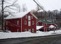
Description |
|---|
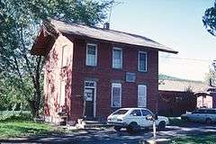
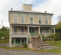
| 1 |
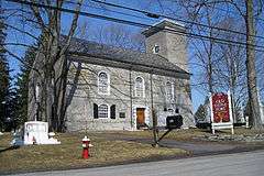
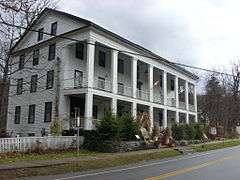
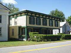
American Hotel |
|
000000001975-09-09-0000September 9, 1975
(#75001228) |
Main St.
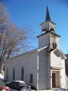
42°47′37″N 74°37′03″W / 42.793611°N 74.6175°W / 42.793611; -74.6175 (American Hotel) |
Sharon Springs |
|
| 2 |
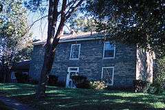
Becker Stone House |
|
000000001979-11-20-0000November 20, 1979
(#79001630) |
East of Schoharie on Murphy Rd.
42°40′22″N 74°15′08″W / 42.672778°N 74.252222°W / 42.672778; -74.252222 (Becker Stone House) |
Schoharie |
|
| 3 |
Becker-Westfall House |
Upload image |
000000001979-11-20-0000November 20, 1979
(#79001631) |
East of Schoharie on NY 443
42°40′33″N 74°15′13″W / 42.675833°N 74.253611°W / 42.675833; -74.253611 (Becker-Westfall House) |
Schoharie |
|
| 4 |
Bellinger-Dutton House |
|
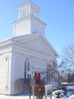
000000002005-12-07-0000December 7, 2005
(#05001380) |
158 River St. (NY 30)
42°36′15″N 74°20′13″W / 42.604167°N 74.336944°W / 42.604167; -74.336944 (Bellinger-Dutton House) |
Middleburgh |
|
| 5 |
Dr. Christopher S. Best House and Office |
|
000000002001-08-15-0000August 15, 2001
(#01000849) |
34 Clauverwie St.
42°35′47″N 74°19′59″W / 42.596389°N 74.333056°W / 42.596389; -74.333056 (Dr. Christopher S. Best House and Office) |
Middleburgh |
|
| 6 |
Bramanville Mill |
|
000000001976-08-27-0000August 27, 1976
(#76001276) |
East of Cobleskill on Caverns Rd.
42°41′17″N 74°24′22″W / 42.688056°N 74.406111°W / 42.688056; -74.406111 (Bramanville Mill) |
Cobleskill |
|
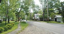
| 7 |
Breakabeen Historic District |
|
000000001974-12-31-0000December 31, 1974
(#74001304) |
Roughly bounded by River St., new Route 30, and Main St. to Bush Rd.
42°31′27″N 74°23′07″W / 42.524167°N 74.385278°W / 42.524167; -74.385278 (Breakabeen Historic District) |
Breakabeen |
|
| 8 |
Bunn-Tillapaugh Feed Mill |
Upload image |
000000002006-09-29-0000September 29, 2006
(#06000894) |
2 High St.
42°37′59″N 74°33′50″W / 42.633056°N 74.563889°W / 42.633056; -74.563889 (Bunn-Tillapaugh Feed Mill) |
Richmondville |
|
| 9 |
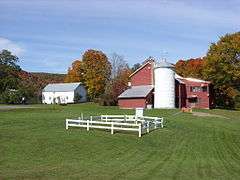
Bute-Warner-Truax Farm |
Upload image |
000000001985-07-25-0000July 25, 1985
(#85001611) |
Truax Rd.
42°34′22″N 74°39′29″W / 42.572778°N 74.658056°W / 42.572778; -74.658056 (Bute-Warner-Truax Farm) |
Charlotteville |
|
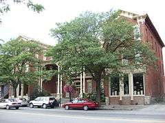
| 10 |
Cobleskill Historic District |
|
000000001978-09-18-0000September 18, 1978
(#78001910) |
Irregular pattern along Washington Ave., Main, Grand, and Elm Sts.
42°40′41″N 74°29′03″W / 42.678056°N 74.484167°W / 42.678056; -74.484167 (Cobleskill Historic District) |
Cobleskill |
|
| 11 |
The Colyer House |
Upload image |
000000002008-02-13-0000February 13, 2008
(#08000025) |
5729 NY 30
42°41′43″N 74°17′51″W / 42.695278°N 74.2975°W / 42.695278; -74.2975 (The Colyer House) |
Schoharie |
|
| 12 |
First Presbyterian Church of Jefferson |
Upload image |
000000002012-08-07-0000August 7, 2012
(#12000481) |
Creamery St. at Park Ave.
42°28′50″N 74°36′48″W / 42.480604°N 74.613222°W / 42.480604; -74.613222 (First Presbyterian Church of Jefferson) |
Jefferson |
Now a museum
|
| 13 |
Forks in the Road Schoolhouse |
Upload image |
000000002005-07-06-0000July 6, 2005
(#05000665) |
115 Lumber Rd.
42°24′43″N 74°33′48″W / 42.411944°N 74.563333°W / 42.411944; -74.563333 (Forks in the Road Schoolhouse) |
South Gilboa |
|
| 14 |
Gallupville Evangelical Lutheran Church |
|
000000002002-12-31-0000December 31, 2002
(#02001652) |
980 NY 443
42°39′48″N 74°14′04″W / 42.663333°N 74.234444°W / 42.663333; -74.234444 (Gallupville Evangelical Lutheran Church) |
Gallupville |
|
| 15 |
Gallupville House |
|
000000001979-09-07-0000September 7, 1979
(#79001629) |
Main St.
42°39′46″N 74°13′58″W / 42.662778°N 74.232778°W / 42.662778; -74.232778 (Gallupville House) |
Gallupville |
|
| 16 |
Gallupville Methodist Church |
|
000000002001-05-30-0000May 30, 2001
(#01000584) |
Factory St.
42°39′45″N 74°14′03″W / 42.6625°N 74.234167°W / 42.6625; -74.234167 (Gallupville Methodist Church) |
Gallupville |
|
| 17 |
Christian Hess House and Shoemaker's Shop |
Upload image |
000000002015-06-30-0000June 30, 2015
(#15000369) |
111 Stony Brook Rd.
42°38′40″N 74°19′12″W / 42.6445°N 74.3199°W / 42.6445; -74.3199 (Christian Hess House and Shoemaker's Shop) |
Schoharie |
|
| 18 |
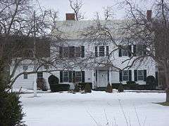
Peter A. Hilton House |
Upload image |
000000002004-09-24-0000September 24, 2004
(#04001063) |
6605 NY 10
42°44′30″N 74°35′24″W / 42.741667°N 74.59°W / 42.741667; -74.59 (Peter A. Hilton House) |
Beekman Corners |
|
| 19 |
House at 461 Spruce Lake Road |
Upload image |
000000002015-01-07-0000January 7, 2015
(#14001130) |
461 Spruce Lake Road
42°35′04″N 74°35′58″W / 42.5845796°N 74.5994658°W / 42.5845796; -74.5994658 (House at 461 Spruce Lake Road) |
Summit |
A rare remaining stacked plank house from the mid-19th century.
|
| 20 |
Lansing Manor House |
|
000000001973-05-25-0000May 25, 1973
(#73001268) |
2 miles (3.2 km) south of North Blenheim on NY 30
42°27′04″N 74°27′54″W / 42.451111°N 74.465°W / 42.451111; -74.465 (Lansing Manor House) |
Blenheim |
|
| 21 |
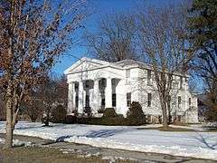
Lasell Hall |
|
000000002002-01-11-0000January 11, 2002
(#01001444) |
350 Main St.
42°39′45″N 74°18′45″W / 42.6625°N 74.3125°W / 42.6625; -74.3125 (Lasell Hall) |
Schoharie |
|
| 22 |
Johannes Lawyer, Jr., House |
Upload image |
000000002016-02-23-0000February 23, 2016
(#16000039) |
194 Main St.
Coordinates missing |
Schoharie |
1790 house dates to post-Revolutionary rebuilding of village, uses a variety of architectural styles
|
| 23 |
John Lehman House |
Upload image |
000000002012-01-04-0000January 4, 2012
(#11001008) |
407 Kilts Rd.
42°47′32″N 74°34′59″W / 42.792203°N 74.583092°W / 42.792203; -74.583092 (John Lehman House) |
Sharon |
|
| 24 |
Livingstonville Community Church |
|
000000002008-01-09-0000January 9, 2008
(#07001370) |
1667 Hauverville Rd.
42°29′24″N 74°16′06″W / 42.49°N 74.268333°W / 42.49; -74.268333 (Livingstonville Community Church) |
Livingstonville |
|
| 25 |
Jacob T. Miers House |
Upload image |
000000002015-12-01-0000December 1, 2015
(#15000857) |
103 Knower Ave.
Coordinates missing |
Schoharie |
1871 Second Empire house that has been home to village library for a half-century
|
| 26 |
North Blenheim Historic District |
|
000000001974-12-31-0000December 31, 1974
(#74001303) |
Both sides of NY 30, beside Schoharie Creek
42°28′13″N 74°27′03″W / 42.470278°N 74.450833°W / 42.470278; -74.450833 (North Blenheim Historic District) |
Blenheim |
|
| 27 |
Old Blenheim Bridge |
|
000000001966-10-15-0000October 15, 1966
(#66000570) |
NY 30 over Schoharie Creek
42°28′21″N 74°26′29″W / 42.4725°N 74.441389°W / 42.4725; -74.441389 (Old Blenheim Bridge) |
North Blenheim |
Destroyed August 28, 2011 in flooding caused by Hurricane Irene[5]
|
| 28 |
Old Lutheran Parsonage |
|
000000001972-06-19-0000June 19, 1972
(#72000913) |
Adjacent to Spring St. in Lutheran Cemetery
42°39′42″N 74°18′31″W / 42.661667°N 74.308611°W / 42.661667; -74.308611 (Old Lutheran Parsonage) |
Schoharie |
|
| 29 |
Old Stone Fort |
|
000000002002-12-31-0000December 31, 2002
(#02001643) |
145 Fort Rd.
42°40′38″N 74°18′08″W / 42.677222°N 74.302222°W / 42.677222; -74.302222 (Old Stone Fort) |
Schoharie |
|
| 30 |
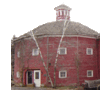
Parker 13-Sided Barn |
|
000000001984-09-29-0000September 29, 1984
(#84002967) |
NY 10
42°28′51″N 74°36′17″W / 42.480833°N 74.604722°W / 42.480833; -74.604722 (Parker 13-Sided Barn) |
Jefferson |
part of the Central Plan Dairy Barns of New York Thematic Resource (TR)
|
| 31 |
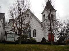
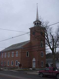
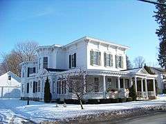
Richmondville United Methodist Church |
|
000000002006-07-14-0000July 14, 2006
(#06000575) |
266 Main St.
42°37′57″N 74°33′56″W / 42.6325°N 74.565556°W / 42.6325; -74.565556 (Richmondville United Methodist Church) |
Richmondville |
|
| 32 |
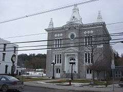
Schoharie County Courthouse Complex |
|
000000001995-08-15-0000August 15, 1995
(#95001010) |
Main St.
42°39′49″N 74°18′44″W / 42.663611°N 74.312222°W / 42.663611; -74.312222 (Schoharie County Courthouse Complex) |
Schoharie |
|
| 33 |
Schoharie Valley Railroad Complex |
|
000000001972-04-26-0000April 26, 1972
(#72000914) |
Depot Lane
42°40′13″N 74°18′39″W / 42.670278°N 74.310833°W / 42.670278; -74.310833 (Schoharie Valley Railroad Complex) |
Schoharie |
|
| 34 |
Shafer Site |
Upload image |
000000001980-11-28-0000November 28, 1980
(#80002764) |
Address Restricted
|
Fulton |
|
| 35 |
Sharon Springs Historic District |
|
000000001994-06-03-0000June 3, 1994
(#94000541) |
Junction of NY 10 and US 20
42°47′32″N 74°36′56″W / 42.792222°N 74.615556°W / 42.792222; -74.615556 (Sharon Springs Historic District) |
Sharon Springs |
|
| 36 |
South Gilboa Railroad Station |
Upload image |
000000002000-02-25-0000February 25, 2000
(#00000090) |
Bailey Spur Rd.
42°24′36″N 74°33′30″W / 42.41°N 74.558333°W / 42.41; -74.558333 (South Gilboa Railroad Station) |
South Gilboa |
|
| 37 |
St. John's Lutheran Church |
Upload image |
000000002008-09-12-0000September 12, 2008
(#08000864) |
6569 NY 10
42°44′28″N 74°35′08″W / 42.741111°N 74.585556°W / 42.741111; -74.585556 (St. John's Lutheran Church) |
Beekman Corners |
|
| 38 |
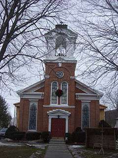
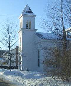
St. Mark's Evangelical Lutheran Church |
|
000000002006-07-14-0000July 14, 2006
(#06000572) |
326 Main St.
42°35′56″N 74°20′07″W / 42.598889°N 74.335278°W / 42.598889; -74.335278 (St. Mark's Evangelical Lutheran Church) |
Middleburgh |
|
| 39 |
St. Paul's Lutheran Church Historic District |
|
000000002014-09-10-0000September 10, 2014
(#14000584) |
312-314 Main St. & Cemetery Ln.
42°39′52″N 74°18′45″W / 42.664328°N 74.3125727°W / 42.664328; -74.3125727 (St. Paul's Lutheran Church Historic District) |
Schoharie |
Church and buildings date to 1740s at earliest, built by Palatine German settlers in region
|
| 40 |
Sternbergh House |
Upload image |
000000001985-03-21-0000March 21, 1985
(#85000629) |
Oak Hill Rd.
42°42′06″N 74°18′07″W / 42.701667°N 74.301944°W / 42.701667; -74.301944 (Sternbergh House) |
Schoharie |
|
| 41 |
Stewart House and Howard–Stewart Family Cemetery |
Upload image |
000000002012-05-08-0000May 8, 2012
(#12000261) |
583 NY 10
42°26′42″N 74°34′56″W / 42.4449°N 74.582106°W / 42.4449; -74.582106 (Stewart House and Howard–Stewart Family Cemetery) |
South Jefferson |
|
| 42 |
Abraham Sternberg House |
Upload image |
000000002010-09-08-0000September 8, 2010
(#10000726) |
150 Route 30A
42°42′06″N 74°18′15″W / 42.701667°N 74.304167°W / 42.701667; -74.304167 (Abraham Sternberg House) |
Schoharie |
|
| 43 |
Terpenning–Johnson House and Cemetery |
Upload image |
000000002013-02-05-0000February 5, 2013
(#12001260) |
674 Brooker Hollow Rd.
42°37′42″N 74°36′27″W / 42.628212°N 74.60763°W / 42.628212; -74.60763 (Terpenning–Johnson House and Cemetery) |
Brooker Hollow |
|
| 44 |
Upper Middleburgh Cemetery |
|
000000002003-11-17-0000November 17, 2003
(#03001144) |
Huntersland Rd.
42°35′24″N 74°19′08″W / 42.59°N 74.318889°W / 42.59; -74.318889 (Upper Middleburgh Cemetery) |
Middleburgh |
|
| 45 |
US Post Office-Middleburgh |
Upload image |
000000001989-05-11-0000May 11, 1989
(#88002352) |
162 Main St.
42°35′52″N 74°20′02″W / 42.597778°N 74.333889°W / 42.597778; -74.333889 (US Post Office-Middleburgh) |
Middleburgh |
part of the US Post Offices in New York State, 1858-1943, TR
|
| 46 |
West Fulton Methodist Church |
|
000000002013-02-05-0000February 5, 2013
(#12001261) |
849 West Fulton Rd.
42°33′49″N 74°27′42″W / 42.563686°N 74.461718°W / 42.563686; -74.461718 (West Fulton Methodist Church) |
West Fulton |
|
| 47 |
Westheimer Site |
Upload image |
000000001980-07-22-0000July 22, 1980
(#80002765) |
Address Restricted
|
Schoharie |
|
| 48 |
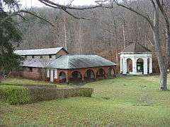
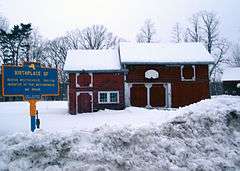
George Westinghouse, Jr., Birthplace and Boyhood Home |
|
000000001986-03-20-0000March 20, 1986
(#86000489) |
Westinghouse Rd.
42°42′32″N 74°19′56″W / 42.708889°N 74.332222°W / 42.708889; -74.332222 (George Westinghouse, Jr., Birthplace and Boyhood Home) |
Central Bridge |
|
.jpg)