| [3] |
Name on the Register |
Image |
Date listed[4] |
Location |
City or town |
Description |
|---|
| 1 |
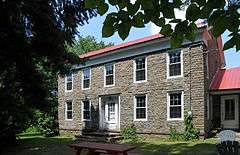
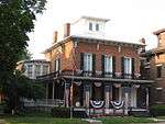
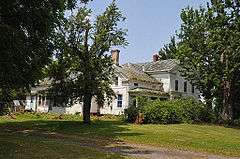
Amelia Bloomer House |
|
000000001980-08-29-0000August 29, 1980
(#80000359) |
53 E. Bayard St.
42°54′35″N 76°47′27″W / 42.909722°N 76.790833°W / 42.909722; -76.790833 (Amelia Bloomer House) |
Seneca Falls |
|
| 2 |
Julius and Harriet Bull House |
Upload image |
000000002007-08-30-0000August 30, 2007
(#07000869) |
2534 Lower Lake Rd.
42°54′14″N 76°45′05″W / 42.903889°N 76.751389°W / 42.903889; -76.751389 (Julius and Harriet Bull House) |
Seneca Falls |
|
| 3 |
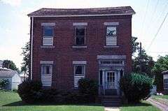
William H. Burton House |
|
000000001996-06-14-0000June 14, 1996
(#96000675) |
35 E. Main St.
42°54′16″N 76°51′41″W / 42.904444°N 76.861389°W / 42.904444; -76.861389 (William H. Burton House) |
Waterloo |
|
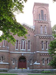
| 4 |
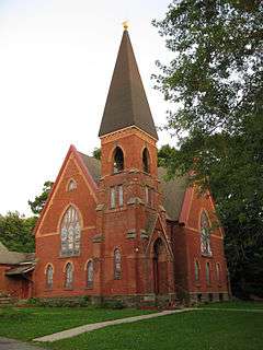
Christ Evangelical and Reformed Church |
Upload image |
000000001989-12-08-0000December 8, 1989
(#89002092) |
Main St.
42°48′52″N 76°47′51″W / 42.814444°N 76.7975°W / 42.814444; -76.7975 (Christ Evangelical and Reformed Church) |
Fayette |
|
| 5 |
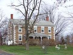
Cobblestone Farmhouse at 1027 Stone Church Rd. |
Upload image |
000000002007-09-28-0000September 28, 2007
(#07001017) |
1027 Stone Church Rd.
42°58′34″N 76°53′05″W / 42.976111°N 76.884722°W / 42.976111; -76.884722 (Cobblestone Farmhouse at 1027 Stone Church Rd.) |
Junius |
|
| 6 |
Cobblestone Farmhouse at 1111 Stone Church Road |
Upload image |
000000002007-09-28-0000September 28, 2007
(#07001018) |
1111 Stone Church Rd.
42°58′19″N 76°52′57″W / 42.972015°N 76.882401°W / 42.972015; -76.882401 (Cobblestone Farmhouse at 1111 Stone Church Road) |
Junius |
|
| 7 |
Cobblestone Farmhouse at 1229 Birdsey Road |
|
000000002008-08-06-0000August 6, 2008
(#08000772) |
1229 Birdsey Rd.
42°58′01″N 76°51′51″W / 42.967039°N 76.864172°W / 42.967039; -76.864172 (Cobblestone Farmhouse at 1229 Birdsey Road) |
Junius |
|
| 8 |
Covert Historic District |
|
000000001980-11-21-0000November 21, 1980
(#80002766) |
NY 96
42°34′22″N 76°41′01″W / 42.572778°N 76.683611°W / 42.572778; -76.683611 (Covert Historic District) |
Covert |
|
| 9 |
Fall Street-Trinity Lane Historic District |
|
000000001974-02-11-0000February 11, 1974
(#74001306) |
Address Restricted
|
Seneca Falls |
|
| 10 |
First Baptist Church of Interlaken |
|
000000002002-12-31-0000December 31, 2002
(#02001655) |
8414 Main St.
42°36′59″N 76°43′32″W / 42.616389°N 76.725556°W / 42.616389; -76.725556 (First Baptist Church of Interlaken) |
Interlaken |
|
| 11 |
First Presbyterian Church |
|
000000001996-11-29-0000November 29, 1996
(#96001386) |
E. Main St., east of the junction with NY 96
42°54′14″N 76°51′39″W / 42.903889°N 76.860833°W / 42.903889; -76.860833 (First Presbyterian Church) |
Waterloo |
|
| 12 |
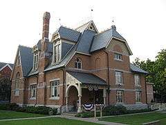
Fourth Ward School |
|
000000001986-03-19-0000March 19, 1986
(#86000474) |
8 Washington St.
42°54′38″N 76°47′21″W / 42.910556°N 76.789167°W / 42.910556; -76.789167 (Fourth Ward School) |
Seneca Falls |
|
| 13 |
John Graves Cobblestone Farmhouse |
Upload image |
000000002008-02-28-0000February 28, 2008
(#08000107) |
1370 NY 318
42°57′35″N 76°52′21″W / 42.959844°N 76.872634°W / 42.959844; -76.872634 (John Graves Cobblestone Farmhouse) |
Junius |
|
| 14 |
William Hoster House |
Upload image |
000000002002-12-31-0000December 31, 2002
(#02001662) |
3832 NY 414
42°50′17″N 76°48′41″W / 42.838056°N 76.811389°W / 42.838056; -76.811389 (William Hoster House) |
Fayette |
|
| 15 |
Hunt House |
|
000000001980-08-29-0000August 29, 1980
(#80000358) |
401 E. Main St.
42°54′22″N 76°50′40″W / 42.906111°N 76.844444°W / 42.906111; -76.844444 (Hunt House) |
Waterloo |
|
| 16 |
David and Mary Kinne Farmstead |
|
000000002007-08-30-0000August 30, 2007
(#07000865) |
6858 Kinne Rd.
42°41′34″N 76°50′34″W / 42.69268°N 76.842662°W / 42.69268; -76.842662 (David and Mary Kinne Farmstead) |
Ovid |
|
| 17 |
Hiram Lay Cobblestone Farmhouse |
Upload image |
000000002009-09-20-0000September 20, 2009
(#09000724) |
1145 Mays Point Rd.
42°58′08″N 76°46′30″W / 42.968883°N 76.775048°W / 42.968883; -76.775048 (Hiram Lay Cobblestone Farmhouse) |
Tyre |
Another Cobblestone Architecture of New York State MPS listing
|
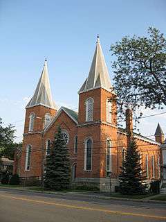
| 18 |
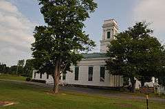
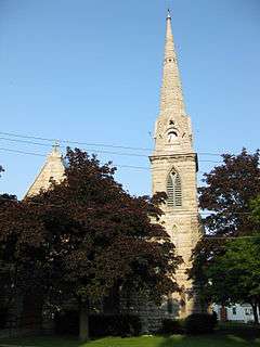
Lodi Methodist Church |
|
000000001982-05-06-0000May 6, 1982
(#82003405) |
S. Main and Grove Sts.
42°36′45″N 76°49′22″W / 42.6125°N 76.822778°W / 42.6125; -76.822778 (Lodi Methodist Church) |
Lodi |
|
| 19 |
M'Clintock House |
|
000000001980-08-29-0000August 29, 1980
(#80000360) |
14 E. Williams
42°54′19″N 76°51′42″W / 42.905278°N 76.861667°W / 42.905278; -76.861667 (M'Clintock House) |
Waterloo |
|
| 20 |
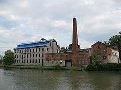
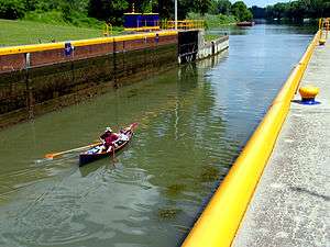
New York State Barge Canal |
|
000000002014-10-15-0000October 15, 2014
(#14000860) |
Linear across county
Coordinates missing |
Seneca Falls, Tyre, Waterloo |
Cayuga–Seneca Canal; Successor to Erie Canal approved by state voters in early 20th century to compete with railroads.
|
| 21 |
Queen's Castle |
Upload image |
000000001999-06-01-0000June 1, 1999
(#99000564) |
NY 414
42°33′03″N 76°52′54″W / 42.550833°N 76.881667°W / 42.550833; -76.881667 (Queen's Castle) |
Lodi |
|
| 22 |
Simon Ritter Cobblestone Farmhouse |
Upload image |
000000002008-11-18-0000November 18, 2008
(#08001081) |
5102 NY 89
42°46′39″N 76°46′11″W / 42.7775°N 76.769722°W / 42.7775; -76.769722 (Simon Ritter Cobblestone Farmhouse) |
Varick |
|
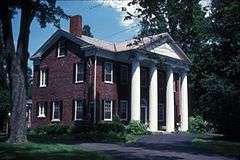
| 23 |
Rose Hill Mansion |
|
000000001973-02-06-0000February 6, 1973
(#73001269) |
West of Fayette on NY 96A
42°51′38″N 76°56′18″W / 42.860556°N 76.938333°W / 42.860556; -76.938333 (Rose Hill Mansion) |
Fayette |
|
| 24 |
Saint Paul's Church |
|
000000001997-03-09-0000March 9, 1997
(#97000115) |
101 E. Williams St.
42°54′20″N 76°51′35″W / 42.905556°N 76.859722°W / 42.905556; -76.859722 (Saint Paul's Church) |
Waterloo |
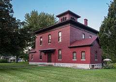
|
| 25 |
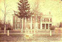
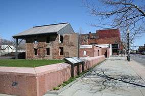
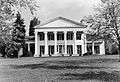
Seneca County Courthouse Complex at Ovid |
|
000000001976-12-12-0000December 12, 1976
(#76001277) |
NY 414
42°40′36″N 76°49′19″W / 42.676667°N 76.821944°W / 42.676667; -76.821944 (Seneca County Courthouse Complex at Ovid) |
Ovid |
|
| 26 |
Seneca Falls Village Historic District |
|
000000001991-04-05-0000April 5, 1991
(#91000342) |
Roughly, properties along State and Cayuga Sts. from Butler and Auburn to Canal St., including Van Cleef Lake
42°54′52″N 76°47′41″W / 42.914415°N 76.79463°W / 42.914415; -76.79463 (Seneca Falls Village Historic District) |
Seneca Falls |
|
| 27 |
Elizabeth Cady Stanton House |
|
000000001966-10-15-0000October 15, 1966
(#66000572) |
32 Washington St.
42°54′45″N 76°47′18″W / 42.9125°N 76.788333°W / 42.9125; -76.788333 (Elizabeth Cady Stanton House) |
Seneca Falls |
|
| 28 |
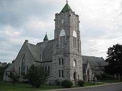
United Methodist Church |
|
000000002004-09-24-0000September 24, 2004
(#04001057) |
21 E. Williams St.
42°54′28″N 76°51′40″W / 42.907778°N 76.861111°W / 42.907778; -76.861111 (United Methodist Church) |
Waterloo |
|
| 29 |
US Post Office-Seneca Falls |
|
000000001989-05-11-0000May 11, 1989
(#88002431) |
34-42 State St.
42°54′42″N 76°47′54″W / 42.911667°N 76.798333°W / 42.911667; -76.798333 (US Post Office-Seneca Falls) |
Seneca Falls |
|
| 30 |
US Post Office-Waterloo |
|
000000001989-05-11-0000May 11, 1989
(#88002442) |
2 E. Main St.
42°54′15″N 76°51′46″W / 42.904167°N 76.862778°W / 42.904167; -76.862778 (US Post Office-Waterloo) |
Waterloo |
|
| 31 |
Waterloo Library |
|
000000001996-06-14-0000June 14, 1996
(#96000676) |
31 Williams St.
42°54′20″N 76°51′40″W / 42.905556°N 76.861111°W / 42.905556; -76.861111 (Waterloo Library) |
Waterloo |
|
| 32 |
James Russell Webster House |
|
000000002007-12-11-0000December 11, 2007
(#07001255) |
115 E. Main St.
42°54′23″N 76°51′33″W / 42.906389°N 76.859167°W / 42.906389; -76.859167 (James Russell Webster House) |
Waterloo |
|
| 33 |
Wesleyan Methodist Church |
|
000000001980-08-29-0000August 29, 1980
(#80000361) |
126 Fall St.
42°57′45″N 76°50′46″W / 42.9625°N 76.846111°W / 42.9625; -76.846111 (Wesleyan Methodist Church) |
Seneca Falls |
|
| 34 |
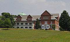
Willard Asylum for the Chronic Insane |
|
000000001975-03-07-0000March 7, 1975
(#75001229) |
Willard State Psychiatric Center
42°40′45″N 76°52′46″W / 42.679167°N 76.879444°W / 42.679167; -76.879444 (Willard Asylum for the Chronic Insane) |
Willard |
|
| 35 |
Aaron Wilson House |
|
000000002001-05-30-0000May 30, 2001
(#01000577) |
2037 Wilson Rd.
42°38′48″N 76°49′55″W / 42.646667°N 76.831944°W / 42.646667; -76.831944 (Aaron Wilson House) |
Ovid |
|
| 36 |
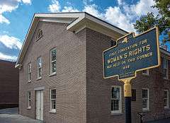
Women's Rights National Historical Park |
|
000000001980-12-28-0000December 28, 1980
(#80004397) |
136 Fall St.
42°54′39″N 76°48′00″W / 42.910706°N 76.800122°W / 42.910706; -76.800122 (Women's Rights National Historical Park) |
Seneca Falls |
|
%2C_Ovid%2C_New_York.jpg)