| [3] |
Name on the Register |
Image |
Date listed[4] |
Location |
City or town |
Description |
|---|
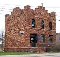
| 1 |
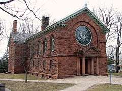
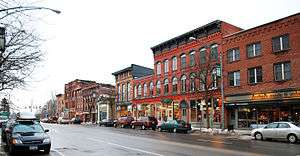
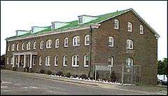
Acker and Evans Law Office |
Upload image |
000000001983-09-15-0000September 15, 1983
(#83001792) |
315 State St.
44°41′50″N 75°29′33″W / 44.697222°N 75.4925°W / 44.697222; -75.4925 (Acker and Evans Law Office) |
Ogdensburg |
|
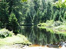
| 2 |
Adirondack Forest Preserve |
|
000000001966-10-15-0000October 15, 1966
(#66000891) |
Northeast New York State
43°58′43″N 74°18′42″W / 43.978611°N 74.311667°W / 43.978611; -74.311667 (Adirondack Forest Preserve) |
St. Lawrence County |
623,000 acres (2,520 km2) of the 6-million-acre (24,000 km2) park are in St. Lawrence County
|
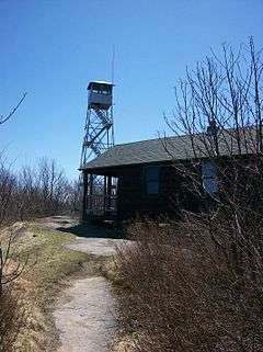
| 3 |
Arab Mountain Fire Observation Station |
|
000000002001-09-23-0000September 23, 2001
(#01001039) |
Arab Mountain
44°12′47″N 74°35′48″W / 44.213056°N 74.596667°W / 44.213056; -74.596667 (Arab Mountain Fire Observation Station) |
Piercefield |
|
| 4 |
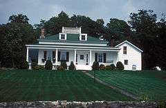
Benjamin Gordon Baldwin House |
Upload image |
000000002004-09-15-0000September 15, 2004
(#04000994) |
26 Baldwin Ave.
44°45′14″N 74°59′26″W / 44.753889°N 74.990556°W / 44.753889; -74.990556 (Benjamin Gordon Baldwin House) |
Norwood |
|
| 5 |
Bayside Cemetery and Gatehouse Complex |
Upload image |
000000002004-03-26-0000March 26, 2004
(#03000026) |
115 Clarkson Ave.
44°39′17″N 74°59′29″W / 44.654722°N 74.991389°W / 44.654722; -74.991389 (Bayside Cemetery and Gatehouse Complex) |
Potsdam |
|
| 6 |
Brick Chapel Church and Cemetery |
Upload image |
000000002005-12-22-0000December 22, 2005
(#05001461) |
5501 Cty Rte 27
44°33′36″N 75°06′58″W / 44.56°N 75.116111°W / 44.56; -75.116111 (Brick Chapel Church and Cemetery) |
Canton |
|
| 7 |
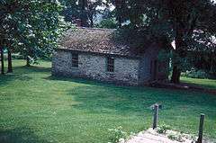
Luke Brown House |
Upload image |
000000002003-06-06-0000June 6, 2003
(#03000030) |
831 NY 72
44°37′45″N 74°54′08″W / 44.629167°N 74.902222°W / 44.629167; -74.902222 (Luke Brown House) |
Parishville |
|
| 8 |
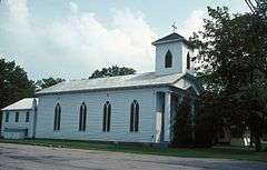
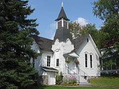
Buck's Bridge United Methodist Church |
Upload image |
000000002004-09-15-0000September 15, 2004
(#04000985) |
2927 Cty Rte 14
44°42′09″N 75°09′39″W / 44.7025°N 75.160833°W / 44.7025; -75.160833 (Buck's Bridge United Methodist Church) |
Buck's Bridge |
|
| 9 |
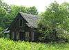
Chase Mills Inn |
Upload image |
000000001978-11-29-0000November 29, 1978
(#78003122) |
Mein and Townline Rds.
44°50′56″N 75°04′52″W / 44.848889°N 75.081111°W / 44.848889; -75.081111 (Chase Mills Inn) |
Chase Mills |
|
| 10 |
Childwold Memorial Presbyterian Church |
Upload image |
000000002001-05-30-0000May 30, 2001
(#01000585) |
Bancroft Rd.
44°17′05″N 74°40′09″W / 44.284722°N 74.669167°W / 44.284722; -74.669167 (Childwold Memorial Presbyterian Church) |
Piercefield |
|
| 11 |
Clare Town Hall |
Upload image |
000000002004-12-06-0000December 6, 2004
(#04001343) |
3441 CR 27
44°26′06″N 75°03′21″W / 44.435°N 75.055833°W / 44.435; -75.055833 (Clare Town Hall) |
Clare |
|
| 12 |
Clarkson Office Building |
|
000000002004-03-05-0000March 5, 2004
(#03000031) |
17 Maple St.
44°40′04″N 74°59′20″W / 44.667778°N 74.988889°W / 44.667778; -74.988889 (Clarkson Office Building) |
Potsdam |
|
| 13 |
Clarkson-Knowles Cottage |
|
000000001995-12-07-0000December 7, 1995
(#95001405) |
37 Main St.
44°40′06″N 74°59′00″W / 44.668333°N 74.983333°W / 44.668333; -74.983333 (Clarkson-Knowles Cottage) |
Potsdam |
|
| 14 |
Congregational Church |
Upload image |
000000002005-12-08-0000December 8, 2005
(#05001387) |
218 Rensselaer St.
44°35′33″N 75°19′07″W / 44.5925°N 75.318611°W / 44.5925; -75.318611 (Congregational Church) |
Rensselaer Falls |
|
| 15 |
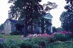
Gardner Cox House |
Upload image |
000000001986-03-20-0000March 20, 1986
(#86000484) |
Main St.
44°36′43″N 74°58′23″W / 44.611944°N 74.973056°W / 44.611944; -74.973056 (Gardner Cox House) |
Hannawa Falls |
|
| 16 |
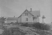
Crossover Island Light Station |
|
000000002007-10-03-0000October 3, 2007
(#07001037) |
Crossover Island
44°29′56″N 75°46′42″W / 44.498889°N 75.778333°W / 44.498889; -75.778333 (Crossover Island Light Station) |
St. Lawrence River |
|
| 17 |
Dr. Buck-Stevens House |
Upload image |
000000001982-05-17-0000May 17, 1982
(#82004745) |
W. Main St.
44°48′27″N 74°46′32″W / 44.8075°N 74.775556°W / 44.8075; -74.775556 (Dr. Buck-Stevens House) |
Brasher Falls |
|
| 18 |
Edwards Town Hall |
Upload image |
000000002004-07-28-0000July 28, 2004
(#04000752) |
161 Main St.
44°19′29″N 75°15′07″W / 44.324722°N 75.251944°W / 44.324722; -75.251944 (Edwards Town Hall) |
Edwards |
|
| 19 |
Fine Town Hall |
Upload image |
000000001996-08-01-0000August 1, 1996
(#96000829) |
91 NY 58
44°14′51″N 75°08′21″W / 44.2475°N 75.139167°W / 44.2475; -75.139167 (Fine Town Hall) |
Fine |
|
| 20 |
Judge John Fine House |
Upload image |
000000001986-01-09-0000January 9, 1986
(#86000012) |
422 State St.
44°41′46″N 75°29′29″W / 44.696111°N 75.491389°W / 44.696111; -75.491389 (Judge John Fine House) |
Ogdensburg |
|
| 21 |
First Congregational Church of Madrid |
Upload image |
000000002010-11-10-0000November 10, 2010
(#10000914) |
6 Cross St.; 32 Main St.
44°45′02″N 75°07′53″W / 44.750556°N 75.131389°W / 44.750556; -75.131389 (First Congregational Church of Madrid) |
Madrid |
|
| 22 |
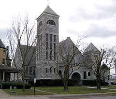
First Presbyterian Church Complex |
|
000000002015-09-17-0000September 17, 2015
(#15000607) |
22 Church St.
44°20′05″N 75°28′14″W / 44.334731°N 75.4705917°W / 44.334731; -75.4705917 (First Presbyterian Church Complex) |
Gouverneur |
1893 Romanesque Revival church made of locally quarried marble
|
| 23 |
First Presbyterian Church of Dailey Ridge |
Upload image |
000000002002-04-01-0000April 1, 2002
(#02000300) |
411 Elliot Rd.
44°44′48″N 75°03′48″W / 44.746667°N 75.063333°W / 44.746667; -75.063333 (First Presbyterian Church of Dailey Ridge) |
Potsdam |
|
| 24 |
Jacob Ford House |
|
000000001982-09-02-0000September 2, 1982
(#82004684) |
Northumberland St.
44°35′09″N 75°39′09″W / 44.585833°N 75.6525°W / 44.585833; -75.6525 (Jacob Ford House) |
Morristown |
|
| 25 |
Fort La Presentation Site |
Upload image |
000000002010-11-26-0000November 26, 2010
(#10000944) |
Lighthouse Point
44°41′44″N 75°30′03″W / 44.695556°N 75.500833°W / 44.695556; -75.500833 (Fort La Presentation Site) |
Ogdensburg |
|
| 26 |
French Family Farm |
Upload image |
000000001982-11-04-0000November 4, 1982
(#82001269) |
Southwest of Potsdam on US 11
44°38′18″N 75°04′18″W / 44.638333°N 75.071667°W / 44.638333; -75.071667 (French Family Farm) |
Potsdam |
|
| 27 |
Harrison Grist Mill |
Upload image |
000000001982-09-16-0000September 16, 1982
(#82004683) |
NY 345
44°39′50″N 75°11′47″W / 44.663889°N 75.196389°W / 44.663889; -75.196389 (Harrison Grist Mill) |
Morley |
|
| 28 |
Hepburn Library |
|
000000002004-09-24-0000September 24, 2004
(#04001056) |
1 Hepburn St.
44°48′09″N 74°59′29″W / 44.8025°N 74.991389°W / 44.8025; -74.991389 (Hepburn Library) |
Norfolk |
|
| 29 |
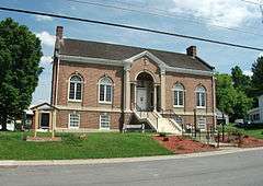
Hepburn Library of Colton |
Upload image |
000000002012-05-16-0000May 16, 2012
(#12000287) |
84 Main St.
44°33′11″N 74°56′20″W / 44.552963°N 74.938926°W / 44.552963; -74.938926 (Hepburn Library of Colton) |
Colton |
|
| 30 |
Hepburn Library of Lisbon |
Upload image |
000000002016-08-22-0000August 22, 2016
(#16000556) |
6899 Lisbon Center State Rd.
Coordinates missing |
Lisbon |
One of seven Hepburn libraries built across the county from 1917–20 by local philanthopist they are named for
|
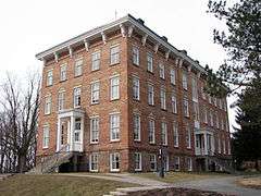
| 31 |
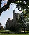
Herring-Cole Hall, St. Lawrence University |
|
000000001974-05-01-0000May 1, 1974
(#74002203) |
St. Lawrence University campus
44°35′32″N 75°09′51″W / 44.592222°N 75.164167°W / 44.592222; -75.164167 (Herring-Cole Hall, St. Lawrence University) |
Canton |
|
| 32 |
Hopkinton Green Historic District |
|
000000002014-09-10-0000September 10, 2014
(#14000583) |
NY 11B, Co. Rd. 49 & Church St
44°41′26″N 74°42′15″W / 44.6906423°N 74.7041681°W / 44.6906423; -74.7041681 (Hopkinton Green Historic District) |
Hopkinton |
Core of small town that grew up around 1803 mill
|
| 33 |
Knollwood |
Upload image |
000000002012-01-04-0000January 4, 2012
(#11001006) |
South end of Inlet Rd. at Oswegatchie River
44°07′28″N 74°57′32″W / 44.124564°N 74.958842°W / 44.124564; -74.958842 (Knollwood) |
Star Lake |
|
| 34 |
Land Office |
|
000000001982-09-02-0000September 2, 1982
(#82004685) |
Main St.
44°35′20″N 75°39′02″W / 44.588889°N 75.650556°W / 44.588889; -75.650556 (Land Office) |
Morristown |
|
| 35 |
Library Park Historic District |
|
000000001982-11-04-0000November 4, 1982
(#82001270) |
303-323 Washington St., 100-112 Carolina St., and Liberty Park
44°41′58″N 75°29′37″W / 44.699444°N 75.493611°W / 44.699444; -75.493611 (Library Park Historic District) |
Ogdensburg |
|
| 36 |
Lisbon Railroad Depot |
Upload image |
000000002000-11-22-0000November 22, 2000
(#00001422) |
6936 Cty Rd. 10
44°43′39″N 75°19′09″W / 44.7275°N 75.319167°W / 44.7275; -75.319167 (Lisbon Railroad Depot) |
Lisbon |
|
| 37 |
Lisbon Town Hall |
Upload image |
000000001980-09-04-0000September 4, 1980
(#80004336) |
Church and Main Sts.
44°43′44″N 75°19′16″W / 44.728889°N 75.321111°W / 44.728889; -75.321111 (Lisbon Town Hall) |
Lisbon |
|
| 38 |
Market Street Historic District |
|
000000001979-11-16-0000November 16, 1979
(#79003171) |
Market and Raymond Sts.
44°40′13″N 74°59′12″W / 44.670278°N 74.986667°W / 44.670278; -74.986667 (Market Street Historic District) |
Potsdam |
|
| 39 |
Paschal Miller House |
|
000000001982-09-02-0000September 2, 1982
(#82004686) |
Main and Gouveneur Sts.
44°35′16″N 75°38′57″W / 44.587778°N 75.649167°W / 44.587778; -75.649167 (Paschal Miller House) |
Morristown |
|
| 40 |
Morristown Schoolhouse |
|
000000001982-09-02-0000September 2, 1982
(#82004687) |
Columbia St.
44°35′06″N 75°38′47″W / 44.585°N 75.646389°W / 44.585; -75.646389 (Morristown Schoolhouse) |
Morristown |
|
| 41 |
New York Central Railroad Adirondack Division Historic District |
|
000000001993-12-23-0000December 23, 1993
(#93001451) |
NYCRR Right-of-Way
44°08′05″N 74°37′50″W / 44.134722°N 74.630556°W / 44.134722; -74.630556 (New York Central Railroad Adirondack Division Historic District) |
Horseshoe |
The New York Central passed through Horseshoe, Mt. Arab Station, and Childwold Station. A 1908 bunkhouse in Horseshoe is extant.
|
| 42 |
New York State Armory |
Upload image |
000000001976-12-12-0000December 12, 1976
(#76002174) |
100 Lafayette St.
44°41′26″N 75°29′36″W / 44.690556°N 75.493333°W / 44.690556; -75.493333 (New York State Armory) |
Ogdensburg |
try also New York State Armory
|
| 43 |
Ogdensburg Armory |
Upload image |
000000001995-03-02-0000March 2, 1995
(#95000088) |
225 Elizabeth St.
44°41′57″N 75°29′23″W / 44.699167°N 75.489722°W / 44.699167; -75.489722 (Ogdensburg Armory) |
Ogdensburg |
|
| 44 |
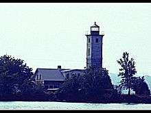
Ogdensburg Harbor Lighthouse |
|
000000002016-04-26-0000April 26, 2016
(#16000202) |
2 Jackson St.
Coordinates missing |
Ogdensburg |
1871 lighthouse at Oswegatchie River confluence with St. Lawrence was key to establishing safe commerce on river.
|
| 45 |
Oswegatchie Pumping Station |
Upload image |
000000001990-06-11-0000June 11, 1990
(#90000816) |
Mechanic St. north of Lafayette St.
44°41′29″N 75°29′32″W / 44.691389°N 75.492222°W / 44.691389; -75.492222 (Oswegatchie Pumping Station) |
Ogdensburg |
|
| 46 |
Nathaniel Parmeter House |
Upload image |
000000002003-06-06-0000June 6, 2003
(#03000027) |
498 NY 59
44°38′33″N 74°59′13″W / 44.6425°N 74.986944°W / 44.6425; -74.986944 (Nathaniel Parmeter House) |
Potsdam |
|
| 47 |
Pickens Hall |
Upload image |
000000002004-10-27-0000October 27, 2004
(#04001205) |
83 State St.
44°37′10″N 75°24′22″W / 44.619444°N 75.406111°W / 44.619444; -75.406111 (Pickens Hall) |
Heuvelton |
|
| 48 |
Pierrepont Town Buildings |
Upload image |
000000001982-11-04-0000November 4, 1982
(#82001271) |
Main St.
44°32′30″N 75°00′39″W / 44.541667°N 75.010833°W / 44.541667; -75.010833 (Pierrepont Town Buildings) |
Pierrepont Center |
|
| 49 |
Potsdam Civic Center Complex |
Upload image |
000000002016-05-03-0000May 3, 2016
(#16000226) |
2 Park St
Coordinates missing |
Potsdam |
Mid-1930s complex built as New Deal relief project of locally quarried stone incorporates 1870s church
|
| 50 |
Potsdam State Normal School Campus |
Upload image |
000000002015-02-23-0000February 23, 2015
(#15000032) |
41 Elm & 56-60 Main Sts.
44°40′07″N 74°58′56″W / 44.6686546°N 74.9823119°W / 44.6686546; -74.9823119 (Potsdam State Normal School Campus) |
Potsdam |
One of the two buildings used by Clarkson University; built around 1917 as sixth such school in state
|
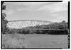
| 51 |
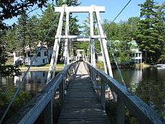
Raymondville Parabolic Bridge |
|
000000001984-09-07-0000September 7, 1984
(#84002961) |
Grant Rd. over Raquette River
44°50′23″N 74°58′47″W / 44.839722°N 74.979722°W / 44.839722; -74.979722 (Raymondville Parabolic Bridge) |
Raymondville |
|
| 52 |
Richardson Hall, St. Lawrence University |
|
000000001974-05-01-0000May 1, 1974
(#74002204) |
St. Lawrence University campus
44°35′31″N 75°09′48″W / 44.591944°N 75.163333°W / 44.591944; -75.163333 (Richardson Hall, St. Lawrence University) |
Canton |
|
| 53 |
Robinson Bay Archeological District |
|
000000001977-09-13-0000September 13, 1977
(#77001524) |
Address Restricted
|
Massena |
|
| 54 |
Russell Town Hall |
Upload image |
000000001996-01-04-0000January 4, 1996
(#95001492) |
Jct. of Main and Mill Sts., NW corner
44°25′46″N 75°09′02″W / 44.429444°N 75.150556°W / 44.429444; -75.150556 (Russell Town Hall) |
Russell |
|
| 55 |
St. Lawrence University-Old Campus Historic District |
|
000000001983-09-15-0000September 15, 1983
(#83001793) |
Park St.
44°35′26″N 75°09′50″W / 44.590556°N 75.163889°W / 44.590556; -75.163889 (St. Lawrence University-Old Campus Historic District) |
Canton |
|
| 56 |
Samuel Stocking House |
Upload image |
000000001982-09-02-0000September 2, 1982
(#82004688) |
83 Gouverneur St.
44°35′18″N 75°38′53″W / 44.588333°N 75.648056°W / 44.588333; -75.648056 (Samuel Stocking House) |
Morristown |
|
| 57 |
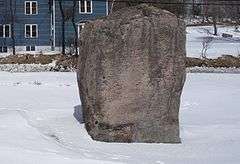
Sunday Rock |
|
000000002010-12-07-0000December 7, 2010
(#10000990) |
NY 56
44°30′35″N 74°53′39″W / 44.509722°N 74.894167°W / 44.509722; -74.894167 (Sunday Rock) |
South Colton |
|
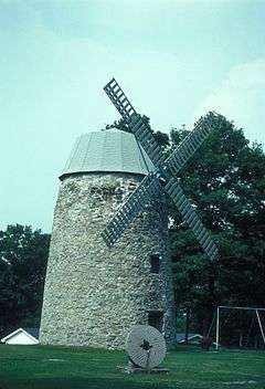
| 58 |
Stone Windmill |
|
000000001982-09-02-0000September 2, 1982
(#82004689) |
Morris St.
44°35′24″N 75°38′50″W / 44.59°N 75.647222°W / 44.59; -75.647222 (Stone Windmill) |
Morristown |
|
| 59 |
Trinity Episcopal Chapel |
Upload image |
000000001990-02-19-0000February 19, 1990
(#90000003) |
Rt. 65, south of Morley
44°39′44″N 75°12′03″W / 44.662222°N 75.200833°W / 44.662222; -75.200833 (Trinity Episcopal Chapel) |
Morley |
|
| 60 |
Trinity Episcopal Church |
|
000000002003-02-13-0000February 13, 2003
(#03000032) |
38 Maple St.
44°40′02″N 74°59′18″W / 44.667222°N 74.988333°W / 44.667222; -74.988333 (Trinity Episcopal Church) |
Potsdam |
|
| 61 |
U.S. Customshouse |
|
000000001974-10-09-0000October 9, 1974
(#74002205) |
127 N. Water St.
44°41′50″N 75°29′52″W / 44.697222°N 75.497778°W / 44.697222; -75.497778 (U.S. Customshouse) |
Ogdensburg |
|
| 62 |
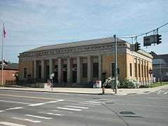
U.S. Post Office-Ogdensburg |
Upload image |
000000001977-08-16-0000August 16, 1977
(#77001525) |
431 State St.
44°36′52″N 75°29′28″W / 44.614444°N 75.491111°W / 44.614444; -75.491111 (U.S. Post Office-Ogdensburg) |
Ogdensburg |
|
| 63 |
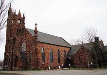
United Methodist Church |
|
000000001982-09-02-0000September 2, 1982
(#82004690) |
Gouveneur St.
44°35′10″N 75°38′46″W / 44.586111°N 75.646111°W / 44.586111; -75.646111 (United Methodist Church) |
Morristown |
|
| 64 |
United Presbyterian Church |
Upload image |
000000002005-10-05-0000October 5, 2005
(#05001124) |
26 Church St.
44°43′47″N 75°19′17″W / 44.729722°N 75.321389°W / 44.729722; -75.321389 (United Presbyterian Church) |
Lisbon |
|
| 65 |
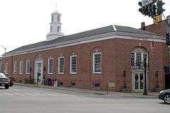
US Post Office-Canton |
|
000000001988-11-17-0000November 17, 1988
(#88002469) |
100 Main St.[5]
44°35′43″N 75°10′09″W / 44.5954°N 75.1692°W / 44.5954; -75.1692 (US Post Office-Canton) |
Canton |
|
| 66 |
US Post Office-Gouverneur |
|
000000001989-05-11-0000May 11, 1989
(#88002516) |
35 Grove St.
44°20′06″N 75°27′58″W / 44.335°N 75.466111°W / 44.335; -75.466111 (US Post Office-Gouverneur) |
Gouverneur |
|
| 67 |
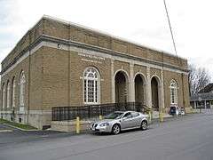
US Post Office-Potsdam |
|
000000001989-05-11-0000May 11, 1989
(#88002410) |
21 Elm St.
44°40′10″N 74°59′05″W / 44.669444°N 74.984722°W / 44.669444; -74.984722 (US Post Office-Potsdam) |
Potsdam |
|
| 68 |
Village Park Historic District |
|
000000001975-05-06-0000May 6, 1975
(#75002087) |
Both sides of Main and Park Sts., and Park Pl.
44°35′43″N 75°10′06″W / 44.595278°N 75.168333°W / 44.595278; -75.168333 (Village Park Historic District) |
Canton |
|
| 69 |
Waddington Historic District |
|
000000001992-05-18-0000May 18, 1992
(#92000457) |
Jct. of NY 37 and La Grasse St.
44°51′49″N 75°12′13″W / 44.863611°N 75.203611°W / 44.863611; -75.203611 (Waddington Historic District) |
Waddington |
|
| 70 |
Jonathan Wallace House |
|
000000002003-06-06-0000June 6, 2003
(#03000028) |
99 Market St.
44°40′19″N 74°59′15″W / 44.671944°N 74.9875°W / 44.671944; -74.9875 (Jonathan Wallace House) |
Potsdam |
|
| 71 |
Wanakena Presbyterian Church |
|
000000002007-09-28-0000September 28, 2007
(#07001015) |
32 Second St.
44°08′09″N 74°55′18″W / 44.135833°N 74.921667°W / 44.135833; -74.921667 (Wanakena Presbyterian Church) |
Wanakena |
Called the Western Adirondack Presbyterian Church
|
| 72 |
Watkins-Sisson House |
Upload image |
000000002013-09-09-0000September 9, 2013
(#13000697) |
14 Leroy Street
44°40′18″N 74°59′01″W / 44.6715618°N 74.9835563°W / 44.6715618; -74.9835563 (Watkins-Sisson House) |
Potsdam |
Mid-1860s brick house given Classical Revival expansion in early 20th century
|
| 73 |
West Stockholm Historic District |
Upload image |
000000001979-11-20-0000November 20, 1979
(#79003172) |
W. Stockholm and Livingston Rds.
44°42′44″N 74°54′08″W / 44.712222°N 74.902222°W / 44.712222; -74.902222 (West Stockholm Historic District) |
West Stockholm |
|
| 74 |
Wright's Stone Store |
|
000000001982-09-02-0000September 2, 1982
(#82004691) |
Main St.
44°35′20″N 75°39′04″W / 44.588889°N 75.651111°W / 44.588889; -75.651111 (Wright's Stone Store) |
Morristown |
|
| 75 |
Young Memorial Church |
Upload image |
000000002011-05-18-0000May 18, 2011
(#11000293) |
Junction of School St. and NY 37
44°31′54″N 75°39′47″W / 44.531667°N 75.663056°W / 44.531667; -75.663056 (Young Memorial Church) |
Brier Hill |
|
| 76 |
Zion Episcopal Church and Rectory |
Upload image |
000000002003-06-06-0000June 6, 2003
(#03000029) |
91 and 95 Main St.
44°33′13″N 74°56′22″W / 44.553611°N 74.939444°W / 44.553611; -74.939444 (Zion Episcopal Church and Rectory) |
Colton |
|