National Register of Historic Places listings in Talbot County, Georgia
This is a list of properties and districts in Talbot County, Georgia that are listed on the National Register of Historic Places (NRHP).
- This National Park Service list is complete through NPS recent listings posted December 16, 2016.[1]
Current listings
| [2] | Name on the Register | Image | Date listed[3] | Location | City or town | Description |
|---|---|---|---|---|---|---|
| 1 | Frederick A. Bailey House | 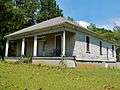 |
(#80001238) |
U.S. 80 32°39′26″N 84°32′06″W / 32.657222°N 84.535°W |
Talbotton | |
| 2 | Newton P. Carreker House | 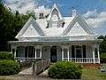 |
(#80001239) |
344 Jackson St. 32°40′46″N 84°32′21″W / 32.679444°N 84.539167°W |
Talbotton | |
| 3 | The Elms | .JPG) |
(#04000930) |
GA 36 at 47 Rising Sun Rd., 3 mi. east of Woodland. 32°47′23″N 84°30′24″W / 32.789722°N 84.506667°W |
Woodland | Circa 1838 |
| 4 | LeVert Historic District | %3B_Talbotton%2C_GA_(NRHP).JPG) |
(#76000649) |
Roughly bounded by Washington Ave., railroad tracks, Madison and Smith Sts. 32°40′28″N 84°32′19″W / 32.674444°N 84.538611°W |
Talbotton | |
| 5 | Lockhart-Cosby Plantation | .JPG) |
(#94001215) |
GA 208 7 mi. E of Talbotton 32°38′38″N 84°22′48″W / 32.643889°N 84.38°W |
Talbot | |
| 6 | John Frank Mathews Plantation | .JPG) |
(#86003456) |
US 80 at George Smith Rd. 32°42′37″N 84°21′36″W / 32.710278°N 84.36°W |
Prattsburg | |
| 7 | David Shelton House | .JPG) |
(#80001240) |
George W. Towns Ave. 32°41′10″N 84°32′04″W / 32.686111°N 84.534444°W |
Talbotton | |
| 8 | Martin and Lucretia Stamper House |  |
(#07000939) |
3224 Flint Hill Hwy (GA 85E) 32°48′21″N 84°39′14″W / 32.805833°N 84.653889°W |
Shiloh | Greek Revival Plantation home built in 1833. Also known as "Merrywood". |
| 9 | Talbot County Courthouse | 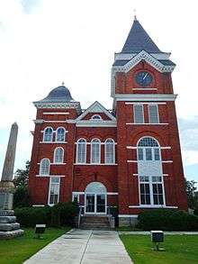 |
(#80001241) |
Courthouse Sq. 32°40′37″N 84°32′27″W / 32.676944°N 84.540833°W |
Talbotton | |
| 10 | George W. B. Towns House | .JPG) |
(#73000644) |
GA 208 32°40′43″N 84°32′45″W / 32.678611°N 84.545833°W |
Talbotton | |
| 11 | Weeks-Kimbrough House | .JPG) |
(#79000747) |
Washington Ave. 32°40′10″N 84°32′05″W / 32.669444°N 84.534722°W |
Talbotton | |
| 12 | Zion Episcopal Church | %3B_Talbotton%2C_GA.JPG) |
(#74000702) |
S of Talbotton on U.S. 80 32°40′28″N 84°32′23″W / 32.674444°N 84.539722°W |
Talbotton |
References
- ↑ "National Register of Historic Places: Weekly List Actions". National Park Service, United States Department of the Interior. Retrieved on December 16, 2016.
- ↑ Numbers represent an ordering by significant words. Various colorings, defined here, differentiate National Historic Landmarks and historic districts from other NRHP buildings, structures, sites or objects.
- ↑ The eight-digit number below each date is the number assigned to each location in the National Register Information System database, which can be viewed by clicking the number.
| Wikimedia Commons has media related to National Register of Historic Places in Talbot County, Georgia. |
| Topics | |
|---|---|
| Lists by states |
|
| Lists by insular areas | |
| Lists by associated states | |
| Other areas | |
| |
This article is issued from Wikipedia - version of the 6/28/2016. The text is available under the Creative Commons Attribution/Share Alike but additional terms may apply for the media files.