National Register of Historic Places listings in Thomas County, Georgia
This is a list of properties and districts in Thomas County, Georgia that are listed on the National Register of Historic Places (NRHP).
- This National Park Service list is complete through NPS recent listings posted December 16, 2016.[1]
Current listings
| [2] | Name on the Register | Image | Date listed[3] | Location | City or town | Description |
|---|---|---|---|---|---|---|
| 1 | D. B. Anderson and Company Building | 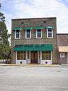 |
(#82002485) |
E. Railroad and Brayton Sts. 30°58′28″N 84°03′14″W / 30.974444°N 84.053889°W |
Ochlocknee | |
| 2 | B'nai Israel Synagogue and Cemetery | 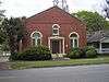 |
(#97001193) |
210 S. Crawford St. 30°51′06″N 83°59′16″W / 30.851667°N 83.987778°W |
Thomasville | |
| 3 | Bethany Congregational Church | Upload image | (#85000453) |
1122 Lester St. 30°49′13″N 83°59′11″W / 30.820278°N 83.986389°W |
Thomasville | |
| 4 | Joe M. Beutell House | Upload image | (#91001158) |
101 Montrose Dr. 30°50′53″N 83°58′17″W / 30.848056°N 83.971389°W |
Thomasville | |
| 5 | Birdwood | Upload image | (#86000917) |
Millpond Rd. and Pinetree Blvd. 30°48′54″N 83°57′52″W / 30.815°N 83.964444°W |
Thomasville | |
| 6 | Boston Historic District | 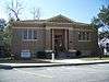 |
(#07000375) |
Roughly bounded by US 84, Roundtree and S. Oak Sts, Washington St. and W. Jefferson and W. Railroad Sts. 30°47′31″N 83°47′24″W / 30.791944°N 83.79°W |
Boston | |
| 7 | Box Hall Plantation | Upload image | (#89002015) |
Lower Cairo Rd. at Pinetree Blvd. 30°49′44″N 84°00′57″W / 30.828889°N 84.015833°W |
Thomasville | |
| 8 | Dr. David Brandon House | 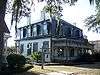 |
(#70000217) |
329 N. Broad St. 30°50′24″N 83°58′59″W / 30.84°N 83.983056°W |
Thomasville | |
| 9 | Hardy Bryan House | 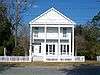 |
(#70000218) |
312 N. Broad St. 30°50′24″N 83°58′54″W / 30.84°N 83.981667°W |
Thomasville | |
| 10 | Burch-Mitchell House | 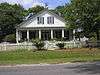 |
(#70000220) |
737 Remington Ave. 30°50′28″N 83°58′00″W / 30.841111°N 83.966667°W |
Thomasville | |
| 11 | Church of the Good Shepherd |  |
(#86003581) |
511-519 Oak St. 30°50′22″N 83°59′17″W / 30.839444°N 83.988056°W |
Thomasville | |
| 12 | Dawson Street Residential Historic District |  |
(#84001251) |
Roughly bounded by North Blvd., Madison, Jackson, and Hansell Sts. 30°50′39″N 83°58′55″W / 30.844167°N 83.981944°W |
Thomasville | |
| 13 | Dewey City Historic District | Upload image | (#08000835) |
Roughly bounded by Martin Luther King, Jr. Dr., Wolf St., Culpepper St., Burns St., and Felix St. 30°50′21″N 83°59′50″W / 30.839167°N 83.997222°W |
Thomasville | |
| 14 | East End Historic District | Upload image | (#84001254) |
Roughly bounded by Metcalf, Loomis, Colton, and Blackshear Sts. (original); roughly bounded by Metcalf Ave., Simeon St., Grady St., and East Loomis St. (increase and decrease), Thomasville, Georgia 30°49′59″N 83°58′11″W / 30.833056°N 83.969722°W |
Thomasville | There was a boundary increase on July 25, 2003 (refnum 03000677) |
| 15 | East Side School |  |
(#77000444) |
120 N. Hansell St. 30°50′37″N 83°58′28″W / 30.843611°N 83.974444°W |
Thomasville | |
| 16 | Fletcherville Historic District | Upload image | (#85000861) |
Roughly bounded by Siexas, Wright, S. College and W. Jackson St. 30°49′49″N 83°58′56″W / 30.830278°N 83.982222°W |
Thomasville | |
| 17 | Glenwood Historic District | Upload image | (#10000826) |
Roughly bounded by Clay St., Glenwood Dr., East Jackson St., and Euclid Dr. 30°50′55″N 83°58′06″W / 30.848611°N 83.968333°W |
Thomasville | |
| 18 | Gordon Avenue Apartments | Upload image | (#83000244) |
424 Gordon Ave. 30°49′49″N 83°58′35″W / 30.830278°N 83.976389°W |
Thomasville | |
| 19 | Gordon Avenue Historic District | Upload image | (#85000860) |
Gordon Ave. 30°49′18″N 83°58′27″W / 30.821667°N 83.974167°W |
Thomasville | |
| 20 | Greenwood Plantation | Upload image | (#76000650) |
GA 84 30°51′09″N 84°01′04″W / 30.8525°N 84.017778°W |
Thomasville | |
| 21 | Augustine Hansell House | 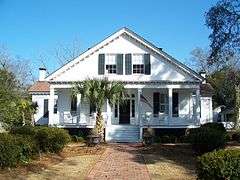 |
(#70000221) |
429 S. Hansell St. 30°50′13″N 83°58′16″W / 30.836944°N 83.971111°W |
Thomasville | |
| 22 | Hollywood Plantation | Upload image | (#03001138) |
1701 Old Monticello Rd. 30°49′13″N 83°57′19″W / 30.820278°N 83.955278°W |
Thomasville | |
| 23 | Judge Henry William and Francesca Hopkins House | 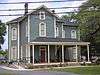 |
(#13000272) |
229 Remington Ave. 30°50′16″N 83°58′36″W / 30.837854°N 83.976595°W |
Thomasville | |
| 24 | Lapham-Patterson House | 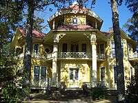 |
(#70000868) |
626 N. Dawson St. 30°50′44″N 83°58′59″W / 30.84562°N 83.98296°W |
Thomasville | A National Historic Landmark and a Georgia state historic site |
| 25 | MacIntyre Park and MacIntyre Park High School | Upload image | (#00000371) |
117 Glenwood Dr. 30°50′44″N 83°58′21″W / 30.845556°N 83.9725°W |
Thomasville | |
| 26 | Melrose and Sinkola Plantations | Upload image | (#89002275) |
SW of Thomasville on US 13 30°47′24″N 84°03′17″W / 30.79°N 84.054722°W |
Thomasville | |
| 27 | Metcalfe Historic District | Upload image | (#78001007) |
Roughly bounded by Magnolia, Hancock, Louis and Williams Sts. 30°42′03″N 83°59′18″W / 30.700833°N 83.988333°W |
Metcalf | |
| 28 | Mill Creek Plantation | Upload image | (#97000300) |
100 Mill Creek Plantation 30°46′03″N 83°55′36″W / 30.7675°N 83.926667°W |
Thomasville | |
| 29 | Millpond Plantation |  |
(#76000651) |
S of Thomasville on Pine Tree Blvd. 30°48′03″N 83°58′19″W / 30.800833°N 83.971944°W |
Thomasville | |
| 30 | Paradise Park Historic District | Upload image | (#84001256) |
Roughly bounded by Metcalf Ave., Colton, Broad, and Loomis Sts. (original), 502 S. Broad St. (increase) 30°49′56″N 83°58′25″W / 30.832222°N 83.973611°W |
Thomasville | There was a boundary increase on April 1, 2002 (refnum 02000292) |
| 31 | Park Front | Upload image | (#70000222) |
711 S. Hansell St. 30°49′55″N 83°58′19″W / 30.831944°N 83.971944°W |
Thomasville | |
| 32 | Pebble Hill Plantation | Upload image | (#90000146) |
US 319, 4 mi. SW of Thomasville 30°46′09″N 84°05′37″W / 30.769167°N 84.093611°W |
Thomasville | |
| 33 | Martha Poe Dogtrot House | Upload image | (#98000569) |
0.75 W of jct of Twelve Mile Post Rd. and GA 19 30°41′34″N 83°50′58″W / 30.692778°N 83.849444°W |
Metcalf | |
| 34 | Ephraim Ponder House | 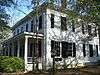 |
(#70000223) |
324 N. Dawson St. 30°50′19″N 83°58′56″W / 30.838611°N 83.982222°W |
Thomasville | |
| 35 | Stevens Street Historic District | Upload image | (#01000500) |
Along Stevens St., 1 blk. NW of Thomas County Courthouse 30°50′28″N 83°59′21″W / 30.841111°N 83.989167°W |
Thomasville | |
| 36 | Thomas County Courthouse |  |
(#70000224) |
N. Broad St. 30°50′20″N 83°58′55″W / 30.838889°N 83.981944°W |
Thomasville | |
| 37 | Thomasville Commercial Historic District | 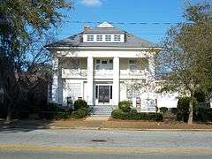 |
(#84001258) |
Roughly N. Stevens, N. Madison, N. Broad, Remington, Jackson, and Jefferson Sts. (original), Downtown Thomasville bet. Jefferson St. and Smith Ave. and bet. Crawford And Siexas St. (increase and decrease) 30°50′12″N 83°58′53″W / 30.836667°N 83.981389°W |
Thomasville | There was a boundary increase on October 28, 2004 (refnum 04001185) |
| 38 | Thomasville Depot | 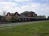 |
(#88000609) |
420 W. Jackson St./US 319 30°50′01″N 83°59′03″W / 30.833611°N 83.984167°W |
Thomasville | |
| 39 | Tockwotton-Love Place Historic District |  |
(#84001260) |
Roughly bounded by McLean Ave., Hansell, Jackson, and Seward Sts. 30°50′24″N 83°58′23″W / 30.84°N 83.973056°W |
Thomasville | |
| 40 | Wright House |  |
(#70000225) |
415 Fletcher St. 30°49′53″N 83°58′55″W / 30.831389°N 83.981944°W |
Thomasville |
Former listings
| [2] | Name on the Register | Image | Date listed | Date removed | Location | City or town | Summary |
|---|---|---|---|---|---|---|---|
| 1 | Thomasville Historic District | Upload image | (#75000610) | Irregular pattern extending N to North Blvd., S to Loomis, E to Hansell, and W to Oak St. |
Thomasville |
References
- ↑ "National Register of Historic Places: Weekly List Actions". National Park Service, United States Department of the Interior. Retrieved on December 16, 2016.
- 1 2 Numbers represent an ordering by significant words. Various colorings, defined here, differentiate National Historic Landmarks and historic districts from other NRHP buildings, structures, sites or objects.
- ↑ The eight-digit number below each date is the number assigned to each location in the National Register Information System database, which can be viewed by clicking the number.
| Wikimedia Commons has media related to National Register of Historic Places in Thomas County, Georgia. |
| Topics | |
|---|---|
| Lists by states |
|
| Lists by insular areas | |
| Lists by associated states | |
| Other areas | |
| |
This article is issued from Wikipedia - version of the 10/9/2016. The text is available under the Creative Commons Attribution/Share Alike but additional terms may apply for the media files.