National Register of Historic Places listings in Turner County, South Dakota
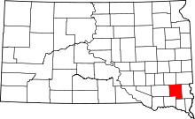
Location of Turner County in South Dakota
This is a list of the National Register of Historic Places listings in Turner County, South Dakota.
This is intended to be a complete list of the properties and districts on the National Register of Historic Places in Turner County, South Dakota, United States. The locations of National Register properties and districts for which the latitude and longitude coordinates are included below, may be seen in a map.[1]
There are 30 properties and districts listed on the National Register in the county. Another 2 properties were once listed but have since been removed.
- This National Park Service list is complete through NPS recent listings posted December 2, 2016.[2]
Current listings
| [3] | Name on the Register[4] | Image | Date listed[5] | Location | City or town | Description |
|---|---|---|---|---|---|---|
| 1 | Archeological Site 39TU5 | Upload image | (#84003417) |
Address Restricted |
Freeman | |
| 2 | Bones Hereford Ranch Sale Barn | Upload image | (#95001472) |
45874 268th St. 43°29′55″N 97°01′17″W / 43.498611°N 97.021389°W |
Parker | |
| 3 | Bridge No. 63-137-090-Parker | Upload image | (#99000951) |
County Road 22 over an unnamed stream 43°22′24″N 97°07′44″W / 43.373333°N 97.128889°W |
Parker | |
| 4 | Brough-Martinson House | Upload image | (#78002570) |
Off Highway 19 43°16′55″N 97°05′24″W / 43.281944°N 97.09°W |
Hurley | |
| 5 | Centerville Township Bridge Number S-18 | Upload image | (#00001216) |
294th St. 43°07′37″N 97°02′20″W / 43.126944°N 97.038889°W |
Centerville | |
| 6 | Childstown Township Bridge Number S-15 | Upload image | (#00001217) |
282nd St. 43°17′58″N 97°12′40″W / 43.299444°N 97.211111°W |
Childstown | |
| 7 | Dalton Township Bridge | Upload image | (#99001439) |
Local road over an unnamed stream 43°26′59″N 97°16′49″W / 43.449722°N 97.280278°W |
Marion | |
| 8 | Daneville Township Bridge No. E-26 | Upload image | (#99001441) |
Local road over an unnamed stream 43°06′04″N 97°03′43″W / 43.101111°N 97.061944°W |
Viborg | |
| 9 | Farrar House | Upload image | (#78002571) |
Off Highway 19 43°17′07″N 97°05′25″W / 43.285278°N 97.090278°W |
Hurley | |
| 10 | Germantown Township Bridge S-29 | Upload image | (#00001219) |
278th St. 43°21′32″N 97°00′29″W / 43.358889°N 97.008056°W |
Germantown | |
| 11 | Glud Theatre | Upload image | (#07000530) |
119 N. Main St. 43°10′23″N 97°04′55″W / 43.173056°N 97.081944°W |
Viborg | |
| 12 | Dr. Harry S. Graves House | Upload image | (#78002572) |
Center Ave. and Monroe St. 43°16′59″N 97°05′26″W / 43.283056°N 97.090556°W |
Hurley | |
| 13 | Tenus Isaac Gunderson House | 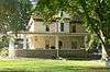 |
(#03001534) |
1041 Washington 43°07′12″N 96°57′50″W / 43.120096°N 96.963879°W |
Centerville | |
| 14 | William Higinbotham House | 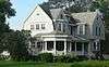 |
(#01000635) |
511 Main St. 43°07′01″N 96°57′20″W / 43.116934°N 96.955527°W |
Centerville | |
| 15 | Chandler Gray and Mary Abbie Newhall House and Homestead Shack | Upload image | (#92000682) |
5 miles west and 4.5 miles south of Parker 43°20′19″N 97°14′22″W / 43.338611°N 97.239444°W |
Parker | |
| 16 | Parker Masonic Hall | Upload image | (#04000761) |
130 S. Cherry Ave. 43°23′55″N 97°08′03″W / 43.398611°N 97.134167°W |
Parker | |
| 17 | Salem Township Bridge Number E-1 | Upload image | (#00001218) |
446th St. 43°14′52″N 97°16′45″W / 43.247778°N 97.279167°W |
Salem | |
| 18 | South Dakota Department of Transportation Bridge No. 63-016-150 | Upload image | (#99001342) |
Local road over an unnamed creek 43°17′06″N 97°22′00″W / 43.285°N 97.366667°W |
Marion | |
| 19 | South Dakota Department of Transportation Bridge No. 63-052-030 | Upload image | (#99001217) |
Local road over the West Fork of the Vermillion River 43°27′32″N 97°17′41″W / 43.458889°N 97.294722°W |
Marion | |
| 20 | South Dakota Department of Transportation Bridge No. 63-132-040 | Upload image | (#99001215) |
Local road over an unnamed stream 43°26′42″N 97°08′09″W / 43.445°N 97.135833°W |
Parker | |
| 21 | South Dakota Department of Transportation Bridge No. 63-160-056 | Upload image | (#99001343) |
Local road over the East Fork of the Vermillion River 43°25′13″N 96°57′31″W / 43.420278°N 96.958611°W |
Parker | |
| 22 | South Dakota Department of Transportation Bridge No. 63-197-130 | Upload image | (#99001210) |
Local road over the East Fork of the Vermillion River 43°19′00″N 97°00′43″W / 43.316667°N 97.011944°W |
Davis | |
| 23 | South Dakota Department of Transportation Bridge No. 63-198-181 | Upload image | (#99001212) |
Local road over the East Fork of the Vermillion River 43°14′31″N 97°00′12″W / 43.241944°N 97.003333°W |
Davis | |
| 24 | South Dakota Department of Transportation Bridge No. 63-210-282 | 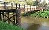 |
(#99001216) |
Local road over the East Fork of the Vermillion River 43°05′46″N 96°58′54″W / 43.096008°N 96.981644°W |
Centerville | Apparently no longer extant[6] |
| 25 | Spring Valley Township Bridge No. E-31 | Upload image | (#99001440) |
Local road over an unnamed stream 43°10′27″N 97°15′33″W / 43.174167°N 97.259167°W |
Viborg | |
| 26 | Thielman-Stoddard House | Upload image | (#79003691) |
132 1st St. 43°23′49″N 97°08′17″W / 43.396944°N 97.138056°W |
Parker | |
| 27 | James S. Thomson House |  |
(#83003021) |
1121 Washington St. 43°07′12″N 96°57′54″W / 43.120085°N 96.964888°W |
Centerville | |
| 28 | Turner Township Bridge No. SE-18 | Upload image | (#00001351) |
459th St. 43°12′48″N 97°01′21″W / 43.213333°N 97.0225°W |
Centerville | |
| 29 | Jacob Weins House-Barn | Upload image | (#84003419) |
Northwestern corner of the southeastern quadrant of Section 14, T99N, R55W[7] Coordinates missing |
Marion | |
| 30 | Wek Farmstead | Upload image | (#03001535) |
44227 288th St. 43°12′44″N 97°21′10″W / 43.212222°N 97.352778°W |
Freeman |
Former listings
| [3] | Name on the Register | Image | Date listed | Date removed | Location | City or town | Summary |
|---|---|---|---|---|---|---|---|
| 1 | I.O.O.F. Hall, Hurley Lodge No. 75 | Upload image | (#82003944) | Center Ave. |
Hurley | ||
| 2 | South Dakota Department of Transportation Bridge No. 63-177-160 | Upload image | (#99001211) | Local Road over Turkey Ridge Creek |
Hurley vicinity | ||
| 3 | South Dakota Department of Transportation Bridge No. 63-186-020 | Upload image | (#99001214) | Local Road over Long Creek |
Parker vicinity |
See also
| Wikimedia Commons has media related to National Register of Historic Places in Turner County, South Dakota. |
- List of National Historic Landmarks in South Dakota
- National Register of Historic Places listings in South Dakota
References
- ↑ The latitude and longitude information provided in this table was derived originally from the National Register Information System, which has been found to be fairly accurate for about 99% of listings. For about 1% of NRIS original coordinates, experience has shown that one or both coordinates are typos or otherwise extremely far off; some corrections may have been made. A more subtle problem causes many locations to be off by up to 150 yards, depending on location in the country: most NRIS coordinates were derived from tracing out latitude and longitudes off of USGS topographical quadrant maps created under the North American Datum of 1927, which differs from the current, highly accurate WGS84 GPS system used by most on-line maps. Chicago is about right, but NRIS longitudes in Washington are higher by about 4.5 seconds, and are lower by about 2.0 seconds in Maine. Latitudes differ by about 1.0 second in Florida. Some locations in this table may have been corrected to current GPS standards.
- ↑ "National Register of Historic Places: Weekly List Actions". National Park Service, United States Department of the Interior. Retrieved on December 2, 2016.
- 1 2 Numbers represent an ordering by significant words. Various colorings, defined here, differentiate National Historic Landmarks and historic districts from other NRHP buildings, structures, sites or objects.
- ↑ National Park Service (2008-04-24). "National Register Information System". National Register of Historic Places. National Park Service.
- ↑ The eight-digit number below each date is the number assigned to each location in the National Register Information System database, which can be viewed by clicking the number.
- ↑ See 2015 photos.
- ↑ Location derived from its NRHP nomination form; the NRIS lists it as "Address Restricted"
| Topics | |
|---|---|
| Lists by states |
|
| Lists by insular areas | |
| Lists by associated states | |
| Other areas | |
| |
Municipalities and communities of Turner County, South Dakota, United States | ||
|---|---|---|
| Cities | | |
| Towns | ||
| Townships | ||
| Unincorporated community | ||
| Footnotes | ‡This populated place also has portions in an adjacent county or counties | |
This article is issued from Wikipedia - version of the 5/9/2016. The text is available under the Creative Commons Attribution/Share Alike but additional terms may apply for the media files.