| [2] |
Name on the Register |
Image |
Date listed[3] |
Location |
City or town |
Description |
|---|
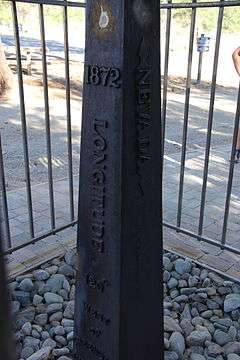
| 1 |
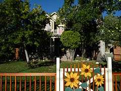
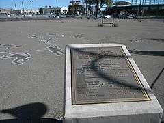
1872 California-Nevada State Boundary Marker |
|
000000001981-08-27-0000August 27, 1981
(#81000387) |
Northwest of Verdi on the California/Nevada border
39°31′28″N 120°00′07″W / 39.524389°N 120.001861°W / 39.524389; -120.001861 (1872 California-Nevada State Boundary Marker) |
Verdi |
|
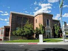
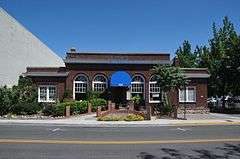
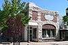
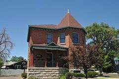
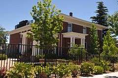
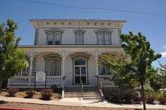
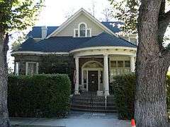
| 2 |
20th Century Club |
|
000000001983-04-21-0000April 21, 1983
(#83001113) |
335 W. 1st St.
39°31′29″N 119°49′02″W / 39.524722°N 119.817222°W / 39.524722; -119.817222 (20th Century Club) |
Reno |
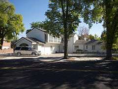
|
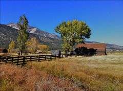
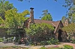
| 3 |
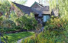
Alamo Ranchhouse |
Upload image |
000000001979-11-23-0000November 23, 1979
(#79001466) |
Southwest of Steamboat at 20205 S. Virginia St.
39°21′51″N 119°45′18″W / 39.364167°N 119.755°W / 39.364167; -119.755 (Alamo Ranchhouse) |
Steamboat |
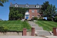
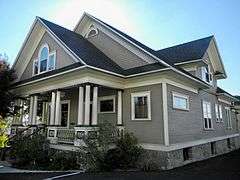
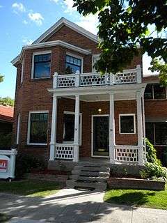
|
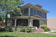
| 4 |
Alpha Tau Omega Fraternity House |
|
000000002004-01-28-0000January 28, 2004
(#03001508) |
205 University Terrace
39°32′08″N 119°49′10″W / 39.535556°N 119.819444°W / 39.535556; -119.819444 (Alpha Tau Omega Fraternity House) |
Reno |
|
| 5 |
Applegate-Lassen Trail |
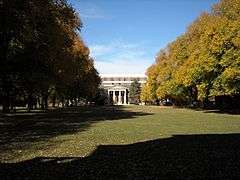
Upload image |
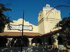
000000001978-12-18-0000December 18, 1978
(#78001722) |
Trail extends from Rye Patch northwest to the California state line
41°11′45″N 119°16′36″W / 41.195833°N 119.276667°W / 41.195833; -119.276667 (Applegate-Lassen Trail) |
High Rock Canyon |
|
| 6 |
Bank of Sparks |
|
000000002007-09-28-0000September 28, 2007
(#07001013) |
948 Victorian Ave.
39°32′06″N 119°45′20″W / 39.535004°N 119.755419°W / 39.535004; -119.755419 (Bank of Sparks) |
Sparks |
|
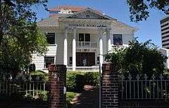
| 7 |
W.E. Barnard House |
|
000000002002-08-22-0000August 22, 2002
(#02000874) |
950 Joaquin Miller Dr.
39°30′47″N 119°49′09″W / 39.513056°N 119.819167°W / 39.513056; -119.819167 (W.E. Barnard House) |
Reno |
|
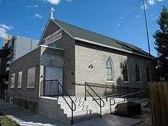
| 8 |
Bethel AME Church |
|
000000002001-06-12-0000June 12, 2001
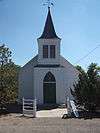
(#01000587) |
220 Bell St.
39°31′34″N 119°49′13″W / 39.526111°N 119.820278°W / 39.526111; -119.820278 (Bethel AME Church) |
Reno |
|
| 9 |
Benson Dillon Billinghurst House |
|
000000001974-11-08-0000November 8, 1974
(#74001151) |
729 Evans Ave.
39°31′51″N 119°48′49″W / 39.530833°N 119.813611°W / 39.530833; -119.813611 (Benson Dillon Billinghurst House) |
Reno |
|
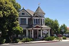
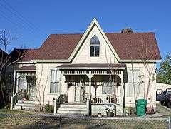
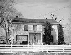
| 10 |
Borland-Clifford House |
|
000000001983-03-07-0000March 7, 1983
(#83001114) |
339 Ralston St.
39°31′42″N 119°49′11″W / 39.528333°N 119.819722°W / 39.528333; -119.819722 (Borland-Clifford House) |
Reno |
|
| 11 |
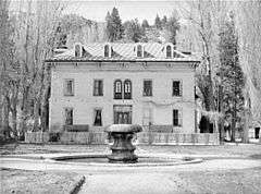
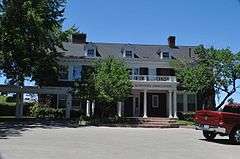
Bowers Mansion |
|
000000001976-01-31-0000January 31, 1976
(#76001143) |
19 miles (31 km) south of Reno off U.S. Route 395
39°17′04″N 119°50′26″W / 39.284444°N 119.840556°W / 39.284444; -119.840556 (Bowers Mansion) |
Reno |
|
| 12 |
Peleg Brown Ranch |
|
000000001994-12-23-0000December 23, 1994
(#94001471) |
12945 Old Virginia Rd.
39°24′43″N 119°44′57″W / 39.411944°N 119.749167°W / 39.411944; -119.749167 (Peleg Brown Ranch) |
Reno |
|
| 13 |
Charles H. Burke House |
|
000000001984-05-31-0000May 31, 1984
(#84002077) |
36 Steward St.
39°31′16″N 119°48′31″W / 39.521111°N 119.808611°W / 39.521111; -119.808611 (Charles H. Burke House) |
Reno |
|
| 14 |
Burke-Berryman House |
|
000000002004-09-15-0000September 15, 2004
(#04000984) |
418 Cheney St.
39°31′06″N 119°48′06″W / 39.518333°N 119.801667°W / 39.518333; -119.801667 (Burke-Berryman House) |
Reno |
|
| 15 |
Cal-Vada Lodge Hotel |
Upload image |
000000001994-06-03-0000June 3, 1994
(#94000551) |
Junction of Stateline Rd. and State Route 28
39°13′38″N 120°00′16″W / 39.227222°N 120.004444°W / 39.227222; -120.004444 (Cal-Vada Lodge Hotel) |
Crystal Bay |
|
| 16 |
California Building |
|
000000001992-09-23-0000September 23, 1992
(#92001257) |
1000 Cowan Dr., Idlewild Park
39°31′19″N 119°50′00″W / 39.521944°N 119.833333°W / 39.521944; -119.833333 (California Building) |
Reno |
|
| 17 |
Walter Cliff Ranch District |
Upload image |
000000001985-09-16-0000September 16, 1985
(#85002428) |
7635 Old U.S. Route 395
39°13′29″N 119°48′42″W / 39.224722°N 119.811667°W / 39.224722; -119.811667 (Walter Cliff Ranch District) |
Washoe Valley |
|
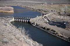
| 18 |
Derby Diversion Dam |
|
000000001978-04-26-0000April 26, 1978
(#78001727) |
19 miles (31 km) east of Sparks on Interstate 80
39°35′09″N 119°26′49″W / 39.585833°N 119.446944°W / 39.585833; -119.446944 (Derby Diversion Dam) |
Sparks |
Extends into Storey County
|
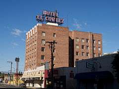
| 19 |
El Cortez Hotel |
|
000000001984-06-13-0000June 13, 1984
(#84002078) |
239 W. 2nd St.
39°31′36″N 119°48′57″W / 39.526667°N 119.815833°W / 39.526667; -119.815833 (El Cortez Hotel) |
Reno |
|
| 20 |
Field Matron's Cottage |
|
000000002003-05-16-0000May 16, 2003
(#03000416) |
1995 E. 2nd St.
39°31′40″N 119°47′11″W / 39.527775°N 119.786461°W / 39.527775; -119.786461 (Field Matron's Cottage) |
Reno |
|
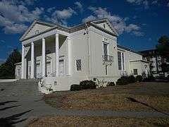
| 21 |
First Church of Christ, Scientist |
|
000000001999-08-20-0000August 20, 1999
(#99000939) |
501 Riverside Dr.
39°31′27″N 119°49′06″W / 39.524167°N 119.818333°W / 39.524167; -119.818333 (First Church of Christ, Scientist) |
Reno |
|
| 22 |
First United Methodist Church |
|
000000001983-02-24-0000February 24, 1983
(#83001115) |
W. 1st and West Sts.
39°31′31″N 119°48′53″W / 39.525278°N 119.814722°W / 39.525278; -119.814722 (First United Methodist Church) |
Reno |
|
| 23 |
Fleischmann Atmospherium Planetarium |
|
000000001994-09-22-0000September 22, 1994
(#94001148) |
N. Virginia St. on the University of Nevada, Reno campus
39°32′46″N 119°49′07″W / 39.546111°N 119.818611°W / 39.546111; -119.818611 (Fleischmann Atmospherium Planetarium) |
Reno |
|
| 24 |
Francovich House |
|
000000001983-04-25-0000April 25, 1983
(#83001116) |
557 Washington St.
39°31′41″N 119°49′10″W / 39.528056°N 119.819444°W / 39.528056; -119.819444 (Francovich House) |
Reno |
|
| 25 |
Frey Ranch |
Upload image |
000000001999-03-05-0000March 5, 1999
(#99000267) |
1140 W. Peckham Ln.
39°29′14″N 119°48′27″W / 39.487222°N 119.8075°W / 39.487222; -119.8075 (Frey Ranch) |
Reno |
|
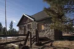
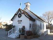
| 26 |
Galena Creek Schoolhouse |
|
000000002011-05-04-0000May 4, 2011
(#11000255) |
16000 Callahan Rd.
39°21′39″N 119°49′06″W / 39.360833°N 119.818333°W / 39.360833; -119.818333 (Galena Creek Schoolhouse) |
Reno |
School Buildings in Nevada MPS
|
| 27 |
Luella Garvey House |
|
000000002004-01-28-0000January 28, 2004
(#03001510) |
589-599 California Ave.
39°31′14″N 119°49′08″W / 39.520556°N 119.818889°W / 39.520556; -119.818889 (Luella Garvey House) |
Reno |
|
| 28 |
Gerlach Water Tower |
|
000000001981-10-29-0000October 29, 1981
(#81000385) |
Main St.
40°39′05″N 119°21′13″W / 40.651389°N 119.353611°W / 40.651389; -119.353611 (Gerlach Water Tower) |
Gerlach |
|
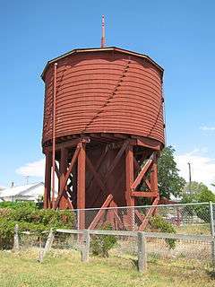
| 29 |
Joseph Giraud House |
|
000000001984-04-05-0000April 5, 1984
(#84002079) |
442 Flint St.
39°31′13″N 119°48′49″W / 39.520278°N 119.813611°W / 39.520278; -119.813611 (Joseph Giraud House) |
Reno |
|
| 30 |
Glendale School |
|
000000001978-01-30-0000January 30, 1978
(#78001729) |
Victorian Square[4]
39°28′58″N 119°47′25″W / 39.482778°N 119.790278°W / 39.482778; -119.790278 (Glendale School) |
Sparks |
|
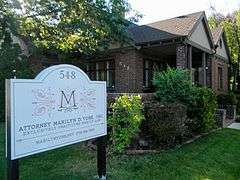
| 31 |
William J. Graham House |
|
000000001983-03-07-0000March 7, 1983
(#83001117) |
548 California Ave.
39°31′12″N 119°49′03″W / 39.52°N 119.8175°W / 39.52; -119.8175 (William J. Graham House) |
Reno |
|
| 32 |
Joseph H. Gray House |
|
000000001987-11-20-0000November 20, 1987
(#87001472) |
457 Court St.
39°31′22″N 119°49′04″W / 39.522778°N 119.817778°W / 39.522778; -119.817778 (Joseph H. Gray House) |
Reno |
|
| 33 |
Greystone Castle |
|
000000002002-08-22-0000August 22, 2002
(#02000875) |
970 Joaquin Miller Dr.
39°30′47″N 119°49′11″W / 39.513056°N 119.819722°W / 39.513056; -119.819722 (Greystone Castle) |
Reno |
|
| 34 |
Hawkins House |
|
000000001979-12-17-0000December 17, 1979
(#79001465) |
549 Court St.
39°31′19″N 119°49′07″W / 39.521944°N 119.818611°W / 39.521944; -119.818611 (Hawkins House) |
Reno |
|
| 35 |
Humphrey House |
|
000000001983-03-07-0000March 7, 1983
(#83001118) |
467 Ralston St.
39°31′47″N 119°49′13″W / 39.529722°N 119.820278°W / 39.529722; -119.820278 (Humphrey House) |
Reno |
|
| 36 |
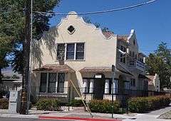
Immaculate Conception Church |
|
000000001992-12-23-0000December 23, 1992
(#92001700) |
528 Pyramid Way[5]
39°32′18″N 119°45′09″W / 39.538428°N 119.752586°W / 39.538428; -119.752586 (Immaculate Conception Church) |
Sparks |
|
| 37 |
J. Clarence Kind House |
|
000000002005-10-05-0000October 5, 2005
(#05001121) |
751 Marsh Ave.
39°31′06″N 119°49′18″W / 39.518333°N 119.821667°W / 39.518333; -119.821667 (J. Clarence Kind House) |
Reno |
|
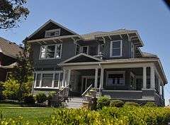
| 38 |
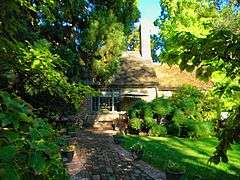
Lake Mansion |
|
000000001972-06-29-0000June 29, 1972
(#72000767) |
250 Court Street
39°31′21″N 119°48′57″W / 39.5226°N 119.8159°W / 39.5226; -119.8159 (Lake Mansion) |
Reno |
|
| 39 |
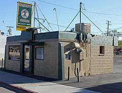
Landrum's Hamburger System No. 1 |
|
000000001998-10-30-0000October 30, 1998
(#98001303) |
1300 S. Virginia St.
39°30′42″N 119°48′17″W / 39.511667°N 119.804722°W / 39.511667; -119.804722 (Landrum's Hamburger System No. 1) |
Reno |
|
| 40 |
Levy House |
|
000000001983-02-24-0000February 24, 1983
(#83001119) |
111-121 California Ave.
39°31′14″N 119°48′40″W / 39.520556°N 119.811111°W / 39.520556; -119.811111 (Levy House) |
Reno |
|
| 41 |
MacKay School of Mines Building |
|
000000001982-04-01-0000April 1, 1982
(#82003258) |
University of Nevada, Reno campus
39°32′22″N 119°48′48″W / 39.539444°N 119.813333°W / 39.539444; -119.813333 (MacKay School of Mines Building) |
Reno |
|
| 42 |
Marlette Lake Water System |
Upload image |
000000001992-09-16-0000September 16, 1992
(#92001162) |
Roughly from Marlette Lake east to State Route 80
39°13′15″N 119°49′17″W / 39.220833°N 119.821389°W / 39.220833; -119.821389 (Marlette Lake Water System) |
Virginia City |
|
| 43 |
McCarthy-Platt House |
|
000000001984-05-31-0000May 31, 1984
(#84002080) |
1000 Plumas St.
39°30′54″N 119°48′42″W / 39.515°N 119.811667°W / 39.515; -119.811667 (McCarthy-Platt House) |
Reno |
|
| 44 |
McKinley Park School |
|
000000001985-09-16-0000September 16, 1985
(#85002406) |
Riverside Dr. and Keystone Ave.
39°31′19″N 119°49′26″W / 39.521944°N 119.823889°W / 39.521944; -119.823889 (McKinley Park School) |
Reno |
|
| 45 |
Miller-Rowe-Holgate House |
|
000000002005-05-26-0000May 26, 2005
(#05000470) |
18 Winter St.
39°31′20″N 119°49′16″W / 39.522222°N 119.821111°W / 39.522222; -119.821111 (Miller-Rowe-Holgate House) |
Reno |
|
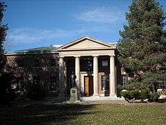
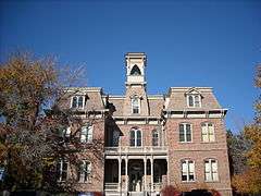
| 46 |
Morrill Hall, University of Nevada/Reno |
|
000000001974-05-01-0000May 1, 1974
(#74001152) |
University of Nevada, Reno campus
39°32′15″N 119°48′46″W / 39.5375°N 119.812778°W / 39.5375; -119.812778 (Morrill Hall, University of Nevada/Reno) |
Reno |
Italianate building
|
| 47 |
Mount Rose Elementary School |
|
000000001977-11-25-0000November 25, 1977
(#77000841) |
915 Lander St.
39°30′56″N 119°48′53″W / 39.515556°N 119.814722°W / 39.515556; -119.814722 (Mount Rose Elementary School) |
Reno |
|
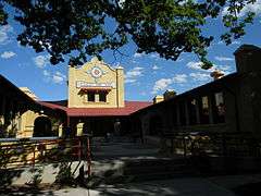
| 48 |
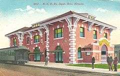
Nevada-California-Oregon Railroad Depot |
|
000000001980-02-08-0000February 8, 1980
(#80002469) |
325 E. 4th St.
39°31′52″N 119°48′34″W / 39.531111°N 119.809444°W / 39.531111; -119.809444 (Nevada-California-Oregon Railroad Depot) |
Reno |
|
| 49 |
Nevada-California-Oregon Railway Locomotive House and Machine Shop |
|
000000001983-05-09-0000May 9, 1983
(#83001120) |
401 E. 4th St.
39°31′52″N 119°48′32″W / 39.531111°N 119.808889°W / 39.531111; -119.808889 (Nevada-California-Oregon Railway Locomotive House and Machine Shop) |
Reno |
|
| 50 |
Senator Francis G. Newlands House |
|
000000001966-10-15-0000October 15, 1966
(#66000459) |
17 Elm Ct.
39°31′17″N 119°49′10″W / 39.521389°N 119.819444°W / 39.521389; -119.819444 (Senator Francis G. Newlands House) |
Reno |
|
| 51 |
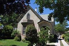
Mary Lee Nichols School |
|
000000002002-10-31-0000October 31, 2002
(#02001277) |
400-406 Pyramid Way
39°32′13″N 119°45′09″W / 39.53706°N 119.75263°W / 39.53706; -119.75263 (Mary Lee Nichols School) |
Sparks |
|
| 52 |
Nortonia Boarding House |
Upload image |
000000001983-02-24-0000February 24, 1983
(#83001121) |
150 Ridge St.
39°31′19″N 119°48′46″W / 39.521944°N 119.812778°W / 39.521944; -119.812778 (Nortonia Boarding House) |
Reno |
|
| 53 |
Nystrom Guest House |
|
000000002000-04-06-0000April 6, 2000
(#00000339) |
333 Ralston St.
39°31′41″N 119°49′11″W / 39.528056°N 119.819722°W / 39.528056; -119.819722 (Nystrom Guest House) |
Reno |
|
| 54 |
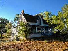
Old Winters Ranch/Winters Mansion |
|
000000001974-07-30-0000July 30, 1974
(#74001150) |
North of Carson City
39°18′43″N 119°49′18″W / 39.311944°N 119.821667°W / 39.311944; -119.821667 (Old Winters Ranch/Winters Mansion) |
New Washoe City |
|
| 55 |
Patrick Ranch House |
|
000000002003-05-16-0000May 16, 2003
(#03000417) |
1225 Gordon Ave.
39°30′44″N 119°49′04″W / 39.512222°N 119.817778°W / 39.512222; -119.817778 (Patrick Ranch House) |
Reno |
|
| 56 |
Peavine Ranch |
Upload image |
000000002000-04-06-0000April 6, 2000
(#00000337) |
11220 N. Virginia St.
39°37′46″N 119°55′13″W / 39.629444°N 119.920278°W / 39.629444; -119.920278 (Peavine Ranch) |
Reno |
|
| 57 |
Pincolini Hotel |
|
000000001984-10-11-0000October 11, 1984
(#84000086) |
214 Lake St.
39°32′11″N 119°48′35″W / 39.536389°N 119.809722°W / 39.536389; -119.809722 (Pincolini Hotel) |
Reno |
|
| 58 |
Pioneer Theater-Auditorium |
|
000000002005-01-19-0000January 19, 2005
(#04001528) |
100 S. Virginia St.
39°31′27″N 119°48′37″W / 39.524167°N 119.810278°W / 39.524167; -119.810278 (Pioneer Theater-Auditorium) |
Reno |
|
| 59 |
Rainier Brewing Company Bottling Plant |
Upload image |
000000001980-03-26-0000March 26, 1980
(#80002470) |
310 Spokane St.
39°31′54″N 119°47′57″W / 39.531667°N 119.799167°W / 39.531667; -119.799167 (Rainier Brewing Company Bottling Plant) |
Reno |
|
| 60 |
Reno National Bank-First Interstate Bank |
|
000000001986-08-06-0000August 6, 1986
(#86002257) |
204 N. Virginia St.
39°31′30″N 119°48′20″W / 39.525°N 119.805556°W / 39.525; -119.805556 (Reno National Bank-First Interstate Bank) |
Reno |
|
| 61 |
Reno Southern Pacific Railroad Depot |
|
000000002012-11-14-0000November 14, 2012
(#12000929) |
280 Commercial Row
39°31′43″N 119°48′37″W / 39.528738°N 119.810371°W / 39.528738; -119.810371 (Reno Southern Pacific Railroad Depot) |
Reno |
|
| 62 |
Riverside Hotel |
|
000000001986-08-06-0000August 6, 1986
(#86002256) |
17 S. Virginia St.
39°31′28″N 119°48′41″W / 39.524444°N 119.811389°W / 39.524444; -119.811389 (Riverside Hotel) |
Reno |
|
| 63 |
Robison House |
|
000000002006-09-29-0000September 29, 2006
(#06000895) |
409 13th St.
39°32′14″N 119°45′35″W / 39.537139°N 119.759681°W / 39.537139; -119.759681 (Robison House) |
Sparks |
|
| 64 |
Southside School |
|
000000001993-08-05-0000August 5, 1993
(#93000683) |
190 E. Liberty
39°31′20″N 119°48′29″W / 39.522222°N 119.808056°W / 39.522222; -119.808056 (Southside School) |
Reno |
|
| 65 |
Twaddle Mansion |
|
000000001983-03-07-0000March 7, 1983
(#83001122) |
485 W. 5th St.
39°31′49″N 119°49′12″W / 39.530278°N 119.82°W / 39.530278; -119.82 (Twaddle Mansion) |
Reno |
|
| 66 |
Twaddle-Pedroli Ranch |
|
000000002000-04-06-0000April 6, 2000
(#00000340) |
4970 Susan Lee Circle
39°16′04″N 119°50′06″W / 39.267778°N 119.835°W / 39.267778; -119.835 (Twaddle-Pedroli Ranch) |
Washoe Valley |
|
| 67 |
Tyson House |
|
000000001983-02-24-0000February 24, 1983
(#83001123) |
242 W. Liberty St.
39°31′15″N 119°48′50″W / 39.520833°N 119.813889°W / 39.520833; -119.813889 (Tyson House) |
Reno |
|
| 68 |
University of Nevada Reno Historic District |
|
000000001987-02-25-0000February 25, 1987
(#87000135) |
Virginia St.
39°32′18″N 119°48′50″W / 39.538333°N 119.813889°W / 39.538333; -119.813889 (University of Nevada Reno Historic District) |
Reno |
|
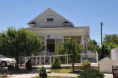
| 69 |
Pearl Upson House |
Upload image |
000000002003-08-14-0000August 14, 2003
(#03000749) |
937 Jones St.
39°31′20″N 119°49′25″W / 39.522222°N 119.823611°W / 39.522222; -119.823611 (Pearl Upson House) |
Reno |
|
| 70 |
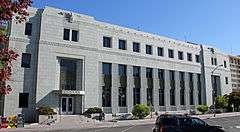
US Post Office-Reno Main |
|
000000001990-02-28-0000February 28, 1990
(#90000135) |
50 S. Virginia St.
39°31′29″N 119°48′39″W / 39.524722°N 119.810833°W / 39.524722; -119.810833 (US Post Office-Reno Main) |
Reno |
|
| 71 |
Vachina Apartments-California Apartments |
|
000000001986-08-06-0000August 6, 1986
(#86002258) |
45 California Ave.
39°31′30″N 119°48′20″W / 39.525°N 119.805556°W / 39.525; -119.805556 (Vachina Apartments-California Apartments) |
Reno |
|
| 72 |
Veterans Memorial School |
Upload image |
000000001995-04-04-0000April 4, 1995
(#93000690) |
1200 Locust St.
39°30′48″N 119°47′53″W / 39.513333°N 119.798056°W / 39.513333; -119.798056 (Veterans Memorial School) |
Reno |
|
| 73 |
Veterans of Foreign Wars Building |
Upload image |
000000002008-06-10-0000June 10, 2008
(#08000511) |
301 Burris Ln.
39°29′21″N 119°47′57″W / 39.489167°N 119.799167°W / 39.489167; -119.799167 (Veterans of Foreign Wars Building) |
Reno |
|
| 74 |
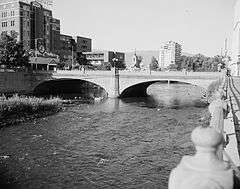
Virginia Street Bridge |
|
000000001980-12-10-0000December 10, 1980
(#80002471) |
Spans the Truckee River
39°31′30″N 119°48′42″W / 39.525°N 119.811667°W / 39.525; -119.811667 (Virginia Street Bridge) |
Reno |
|
| 75 |
Wadsworth Union Church |
|
000000002004-04-15-0000April 15, 2004
(#04000298) |
Junction of Lincoln Highway and Railroad Ave.
39°38′07″N 119°17′00″W / 39.635278°N 119.283333°W / 39.635278; -119.283333 (Wadsworth Union Church) |
Wadsworth |
|
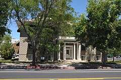
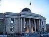
| 76 |
Washoe County Courthouse |
|
000000001986-08-06-0000August 6, 1986
(#86002254) |
117 S. Virginia St.
39°31′25″N 119°48′24″W / 39.523611°N 119.806667°W / 39.523611; -119.806667 (Washoe County Courthouse) |
Reno |
|
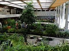
| 77 |
Washoe County Library |
|
000000002013-02-13-0000February 13, 2013
(#13000011) |
301 S. Center St.
39°31′20″N 119°48′37″W / 39.522292°N 119.810287°W / 39.522292; -119.810287 (Washoe County Library) |
Reno |
|
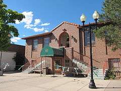
| 78 |
Washoe County Library-Sparks Branch |
|
000000001992-03-09-0000March 9, 1992
(#92000116) |
814 Victorian St.
39°32′07″N 119°45′08″W / 39.535278°N 119.752222°W / 39.535278; -119.752222 (Washoe County Library-Sparks Branch) |
Sparks |
|
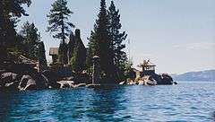
| 79 |
Whittell Estate |
|
000000002000-10-27-0000October 27, 2000
(#00001207) |
5000 State Route 28
39°10′25″N 119°55′10″W / 39.173611°N 119.919444°W / 39.173611; -119.919444 (Whittell Estate) |
Incline Village |
Also known as Thunderbird Lodge
|
| 80 |
Withers Log House |
Upload image |
000000002000-04-06-0000April 6, 2000
(#00000341) |
344 Wassou
39°14′11″N 120°00′04″W / 39.236389°N 120.001111°W / 39.236389; -120.001111 (Withers Log House) |
Crystal Bay |
|


_from_NW_2.JPG)
.jpg)
.JPG)
_from_E_1.JPG)