Naustdal (village)
| Naustdal | |
|---|---|
| Village | |
|
View of the village | |
 Naustdal  Naustdal Location in Sogn og Fjordane county | |
| Coordinates: 61°30′39″N 05°43′00″E / 61.51083°N 5.71667°ECoordinates: 61°30′39″N 05°43′00″E / 61.51083°N 5.71667°E | |
| Country | Norway |
| Region | Western Norway |
| County | Sogn og Fjordane |
| District | Sunnfjord |
| Municipality | Naustdal |
| Area[1] | |
| • Total | 0.7 km2 (0.3 sq mi) |
| Elevation[2] | 8 m (26 ft) |
| Population (2013)[1] | |
| • Total | 1,146 |
| • Density | 1,637/km2 (4,240/sq mi) |
| Time zone | CET (UTC+01:00) |
| • Summer (DST) | CEST (UTC+02:00) |
| Post Code | 6817 Naustdal |
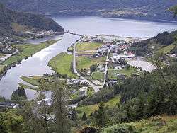
Naustdal is the administrative centre of Naustdal Municipality in Sogn og Fjordane county, Norway. The village is located on the northern shore of the Førdefjorden at the mouth of the river Nausta, which flows through the Naustdalen valley. The village sits about 12 kilometres (7.5 mi) northwest of the town of Førde and about 10 kilometres (6.2 mi) northeast of the village of Helle.[3]
The 0.7-square-kilometre (170-acre) village has a population (2013) of 1,146 which gives the village a population density of 1,637 inhabitants per square kilometre (4,240/sq mi).[1] The Naustdal Church is located in this village, and it serves as the main church for the municipality. The village has been the site of a church since the middle ages.
The Norwegian National Road 5 highway runs through the village on its way from the town of Førde to the town of Florø which is about 40 kilometres (25 mi) to the northeast. The Naustdal Tunnel has its southern entrance at this village.
References
- 1 2 3 Statistisk sentralbyrå (1 January 2013). "Urban settlements. Population and area, by municipality.".
- ↑ "Naustdal" (in Norwegian). yr.no. Retrieved 2013-11-18.
- ↑ Store norske leksikon. "Naustdal tettbebyggelse" (in Norwegian). Retrieved 2013-11-18.