Naval Communication Station Harold E. Holt
Coordinates: 21°48′59″S 114°09′56″E / 21.816405°S 114.16563°E
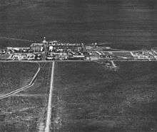
Naval Communication Station Harold E. Holt is located on the northwest coast of Australia, 6 kilometres (4 mi) north of the town of Exmouth, Western Australia. The town of Exmouth was built at the same time as the communications station to provide support to the base and to house dependent families of U.S. Navy personnel.
The station provides very low frequency (VLF) radio transmission to United States Navy and Royal Australian Navy ships and submarines in the western Pacific Ocean and eastern Indian Ocean. The frequency is 19.8 kHz. With a transmission power of 1 megawatt, it is the most powerful transmission station in the Southern Hemisphere.[1]
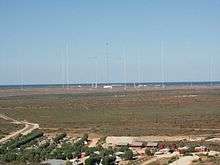
VLF Transmitter Masts
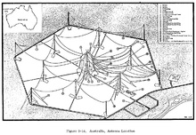
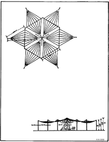
The station features thirteen tall radio towers. The tallest tower is called Tower Zero and is 387 m (1,270 ft) tall, and was for many years the tallest man-made structure in the Southern Hemisphere. Six towers, each 304 metres tall, are placed in a hexagon around Tower Zero. The other six towers, which are each 364 metres tall, are placed in a larger hexagon around Tower Zero.
| Structure | Height | Location | |
|---|---|---|---|
| m | ft | ||
| Tower 0 | 387 | 1,270 | 21°48′58″S 114°9′55″E / 21.81611°S 114.16528°E |
| Tower 1 | 304 | 997 | 21°48′35″S 114°9′57″E / 21.80972°S 114.16583°E |
| Tower 2 | 304 | 997 | 21°48′48″S 114°10′18″E / 21.81333°S 114.17167°E |
| Tower 3 | 304 | 997 | 21°49′12″S 114°10′16″E / 21.82000°S 114.17111°E |
| Tower 4 | 304 | 997 | 21°49′23″S 114°9′54″E / 21.82306°S 114.16500°E |
| Tower 5 | 304 | 997 | 21°49′10″S 114°9′32″E / 21.81944°S 114.15889°E |
| Tower 6 | 304 | 997 | 21°48′45″S 114°9′33″E / 21.81250°S 114.15917°E |
| Tower 7 | 364 | 1,194 | 21°48′25″S 114°10′19″E / 21.80694°S 114.17194°E |
| Tower 8 | 364 | 1,194 | 21°49′1″S 114°10′38″E / 21.81694°S 114.17722°E |
| Tower 9 | 364 | 1,194 | 21°49′35″S 114°10′14″E / 21.82639°S 114.17056°E |
| Tower 10 | 364 | 1,194 | 21°49′33″S 114°9′31″E / 21.82583°S 114.15861°E |
| Tower 11 | 364 | 1,194 | 21°48′56″S 114°9′11″E / 21.81556°S 114.15306°E |
| Tower 12 | 364 | 1,194 | 21°48′22″S 114°9′35″E / 21.80611°S 114.15972°E |
On 3 March 2009, the Defence Materiel Organisation advertised on the AusTender website a tender to construct two new roads at the station. The tender stated the 357 guy wires which support the 13 towers had exceeded their life expectancy and the roads will support the installation of the VLF guy wires. It states: Naval Communication Station Harold E Holt (NCSHEH) is sited on the northernmost tip of the peninsula known as North West Cape. The Very Low Frequency (VLF) antennas are large spider webs of wire supported in a top hat arrangement. The centre tower ‘Tower Zero’, rises to a height of 387.9 metres. The other towers are spread out in two concentric rings around Tower Zero; the towers of the inner ring are 364 metres high while those of the outer ring are 304 metres high. Buried in the ground beneath the antenna array is 386 kilometres of bare copper ground mat.[2]
History
Sir Garfield Barwick, Australian Minister for External Affairs, negotiated the lease on the US Base at North West Cape in 1963 with U.S. ambassador William Battle. The station was commissioned as U.S. Naval Communication Station North West Cape on 16 September 1967 at a ceremony with the US Ambassador to Australia Ed Clark and the Prime Minister of Australia Harold Holt, at which peppercorn rent for the base for the first year was paid.[3]
On 20 September 1968, the station was officially renamed to U.S. Naval Communication Station Harold E. Holt in memory of the late Harold Holt, former Prime Minister of Australia, who disappeared whilst swimming and was declared dead, presumed drowned, three months after the station was commissioned.
With the election of the Labor Government to power in 1972, Defence Minister Lance Barnard started negotiations on the condition of operation of the U.S. military bases in Australia. On 9 January 1974 a joint statement by Lance Barnard and James Schlesinger, the US Secretary of Defense: assigned the Deputy Commander of the base to a Royal Australian Navy officer and gave Australian personnel roles in base technical and maintenance functions. The cipher room was closed to Australian scrutiny. The joint statement stressed the importance of consultations in crises. There was no undertaking given by the USA to relay fire orders to their submarines bearing nuclear missiles.[4]
In May 1974 several hundred people traveled to North West Cape from around Australia to protest and occupy the base and "symbolically reclaiming it for the Australian people".[3] During the occupation the Eureka Flag was flown over the base with fifty-five people arrested during the protest. Songs composed in the campaign against North West Cape and other US bases in Australia include We don't want no Yankee Bases and Omega Doodle which have become part of the Australian folkloric tradition.[5] From 1967 until October 1992 a Naval Security Group Detachment was stationed at the facility.[6]
In Western Australian domestic politics, the presence of foreign military installations in the state has occasionally been questioned over the decades.[7] The "U.S." was dropped from the station's official title with the advent of joint U.S. and Royal Australian Navy operation in 1974. The majority of U.S. Naval presence ended in 1993 with the withdrawal of all U.S. Naval personnel.[8]
In July 2002, the Royal Australian Navy handed over operation of the station to the Defence Materiel Organisation.[8] The base is currently operated under contract by Raytheon Australia.[9] On 15 July 2008, Australia and the US signed a bilateral treaty governing the future joint use of the facility for the next 25 years.[10]
Harold E. Holt was identified as a potential Air Force Space Surveillance System (or Space Fence) site in 2011.[11] On 6 December 2013 it was announced that the Space Surveillance Telescope (SST), part of the United States Space Surveillance Network, will be relocated to the Harold E. Holt Naval Communication Station from its initial deployment at the White Sands Missile Range in New Mexico. The SST was expected to be ready for operations in 2016.[12] It has since been announced that DARPA handed over control of the SST optical telescope to the US Air Force in October 2016 and it will be transferred to Harold E. Holt Naval Communication Station and become operational in 2020.[13]
A C-Band Space Surveillance Radar is also being installed and once completed will be operated remotely by Royal Australian Air Force personnel from No. 1 Remote Sensor Unit at RAAF Base Edinburgh. It will provide a Space Situational Awareness capability, allowing the tracking of space assets and debris.[14]
Aircraft interference controversy
On 7 October 2008, Qantas Flight 72 made an emergency landing at Learmonth airport near the town of Exmouth, Western Australia following an inflight accident featuring a pair of sudden uncommanded pitch-down manoeuvres that resulted in serious injuries to many of the occupants.[15][16][17][18][19] The Australian Transport Safety Bureau (ATSB) identified in a preliminary report that a fault occurred within the Number 1 Air Data Inertial Reference Unit (ADIRU) and is the "likely origin of the event". The ADIRU — one of three such devices on the aircraft — began to supply incorrect data to the other aircraft systems.[18][20] The ATSB's continuing accident investigation will include assessment of speculation that possible interference from Harold E. Holt facility or passenger personal electronic devices could have been involved, although based on initial analysis, the Bureau believes these are unlikely to have been of any impact.[18][21][22]
On 27 December 2008, another aircraft, Qantas Flight 71, also had a malfunction in its ADIRU. The incident again fuelled media speculation regarding the significance of the Harold E. Holt facility, with the Australian and International Pilots Association calling for commercial aircraft to be barred from the area as a precaution until the events are better understood,[23][24] while the manager of the facility has claimed that it is "highly, highly unlikely" that any interference has been caused.[25]
See also
References
- ↑ Shears, Richard (16 October 2008). "Signals from naval base 'caused Qantas passenger jet to plunge 650ft in seconds'". Daily Mail Online. Retrieved 1 September 2016. The base sends radio signals to US Navy and Royal Australian Navy ship and submarines in the western Pacific Ocean and the eastern Indian Ocean and is the most powerful transmission station in the Southern Hemisphere.
- ↑ , AusTenders. Accessed 18 November 2009
- 1 2 Builders' Labourers' Song Book, pp190-194, Published by Widescape International and the BLF, 1975. ISBN 0-86932-010-6. A recording was released of the speech by US ambassador Ed Clark titled "Ed Clark Pulls It Off", Liberation Records, Melbourne, Australia (April 1974)
- ↑ Secrets of State by George Munster, Published by Walsh & Munster (an imprint of Angus and Robertson) 1982 ISBN 0-207-14634-9
- ↑ Warren Fahey, The Balls of Bob Menzies: Australian Political Songs 1900-1980, pp288-289, pp299-300, Angus and Robertson Publishers, 1989, ISBN 0-207-16204-2
- ↑
- ↑ Barker, E. A.(1985) Brian Burke supports the role of US communications base at NW Cape, West Australian, 25 Nov. 1985, p.3,
- 1 2 "Naval Communication Station Harold E Holt ( Area A ) (Place ID 103552)". Australian Heritage Database. Department of the Environment. Retrieved 26 August 2007.
- ↑ "Mission Support Overview". Raytheon Australia. Retrieved 14 July 2016.
- ↑ Signing of Harold E. Holt Treaty, Australian Department of Defence
- ↑ Payne, Rob. "WA in the running for Space Fence". Astronomy WA. Archived from the original on 23 March 2012. Retrieved 9 September 2011.
- ↑ "SST AUSTRALIA: SIGNED, SEALED AND READY FOR DELIVERY". DARPA. Retrieved 18 August 2014.
- ↑ http://www.space.com/34452-darpa-hands-over-space-tracking-telescope-to-the-air-force.html
- ↑ "US Space Radar at Exmouth". DMO Bulletin. Defence Materiel Organisation (2). 2014. Retrieved 26 October 2014.
- ↑ "2008/40 - Qantas Airbus Incident Media Conference" (Press release). Australian Transport Safety Bureau. 8 October 2008. Retrieved 8 October 2008.
- ↑ "2008/40a — ATSB Airbus investigation update" (Press release). Australian Transport Safety Bureau. 9 October 2008. Retrieved 14 October 2008.
- ↑ "2008/40b — Qantas Airbus Accident Media Conference" (Press release). Australian Transport Safety Bureau. 10 October 2008. Retrieved 14 October 2008.
- 1 2 3 "2008/43 - Qantas Airbus A330 accident Media Conference" (Press release). Australian Transport Safety Bureau. 14 October 2008. Retrieved 14 October 2008.
- ↑ Siddique, Haroon (7 October 2008). "Qantas flight makes emergency landing as dozens of passengers injured". The Guardian. Retrieved 7 October 2008.
- ↑ "Computer glitch may be behind Qantas incident: ATSB". Australian Broadcasting Corporation. 8 October 2008. Retrieved 8 October 2008.
- ↑ Butterly, Nick (16 October 2008). "Exmouth base linked to Airbus incident". The West Australian. Archived from the original on 16 October 2008. Retrieved 16 October 2008.
- ↑ Johnson, Ed (16 October 2008). "Qantas Plunge Investigators to Examine Naval Base Transmissions". Bloomberg. Retrieved 16 October 2008.
- ↑ Catanzaro, Joseph (2 January 2009). "Navigation failure again hits Qantas in north-west". The Age. Retrieved 2 January 2009.
- ↑ "Call for no-go zone after another Qantas forced landing". The Age. 2 January 2009. Retrieved 2 January 2009.
- ↑ Hopkin, Michael (7 January 2009). "Exmouth interference 'unlikely'". Sydney Morning Herald. Retrieved 7 January 2009.
Further reading
- Barker, Anthony J; Ondaatje, Michael L (2015). A Little America in Western Australia: The US naval communication station at North West Cape and the founding of Exmouth. Crawley, WA: UWA Publishing. ISBN 9781742586854.
- Barker, E. A.(1985) Brian Burke supports the role of US communications base at NW Cape. West Australian, 25 Nov. 1985, p. 3,
- http://www.exmouth.wa.gov.au/default.asp?et=3&ei=18
- http://www.skyscraperpage.com/diagrams/?b575
- http://www.globalsecurity.org/military/facility/exmouth.htm
- Ring Masts at Naval Communication Station Harold E. Holt at Structurae
- Tower 0 of Naval Communication Station Harold E. Holt at Structurae
External links
- "Google" satellite map: the map opens centered on the "Area A" very low frequency (VLF) towers site, which is at the northernmost edge of the Northwest Cape, approximately 4 miles north of the Main base; the "Area B" high frequency receiver (HFR) site was approximately 30 miles south of the Main Base
- "Google" street view: The view from the side of the road with Tower 9 in the foreground.