Nazaré Paulista
| Nazaré Paulista | ||
|---|---|---|
| Municipality | ||
 | ||
| ||
 Location in São Paulo state | ||
 Nazaré Paulista Location in Brazil | ||
| Coordinates: 23°10′51″S 46°23′42″W / 23.18083°S 46.39500°WCoordinates: 23°10′51″S 46°23′42″W / 23.18083°S 46.39500°W | ||
| Country |
| |
| Region | Southeast Region | |
| State | São Paulo | |
| Area[1][2] | ||
| • Total | 326.3 km2 (126.0 sq mi) | |
| Elevation | 845 m (2,772 ft) | |
| Population (2015)[1] | ||
| • Total | 17,794 | |
| • Density | 55/km2 (140/sq mi) | |
| Time zone | BRT/BRST (UTC-3/-2) | |
| Website |
nazarepaulista | |

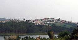
Nazaré Paulista is a municipality in the state of São Paulo in Brazil. The population is 17,794 (2015 est.) in an area of 326.3 km².[1] It is within the Atlantic Forest biome and is a major source of water for the city of São Paulo, hosting the Atibainha reservoir of the Cantareira System. Nazaré Paulista is also home to the nationally known conservation organization, the Instituto de Pesquisas Ecológicas (Institute for Ecological Research).
References
- 1 2 3 Instituto Brasileiro de Geografia e Estatística
- ↑ IBGE (10 October 2002). "Área territorial oficial" (in Portuguese). Resolução da Presidência do IBGE de n° 5 (R.PR-5/02. Retrieved 7 October 2012.
This article is issued from Wikipedia - version of the 5/14/2016. The text is available under the Creative Commons Attribution/Share Alike but additional terms may apply for the media files.