Ness of Burgi
Coordinates: 59°51′35″N 1°18′38″W / 59.859644°N 1.31042°W
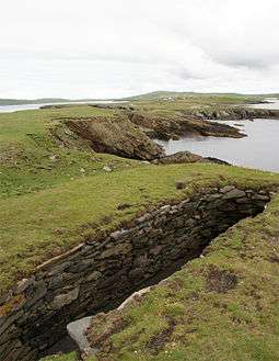 Northern part of the Ness looking inland towards Scatness. The structure in the foreground is part of the Ness of Burgi fort | |
| Location | |
|---|---|
 Ness of Burgi Ness of Burgi shown within Scotland | |
| OS grid reference | HU 3877 0855 |
| Physical geography | |
| Island group | Shetland |
| Administration | |
| Sovereign state | United Kingdom |
| Country | Scotland |
| Council area | Shetland Islands |
The Ness of Burgi is a narrow peninsula that stretches to the south from the Scat Ness headland of Mainland, Shetland, a Scottish island. It is in the parish of Dunrossness.
The Ness is less than 1 kilometre (0.62 mi) long, running in south of southwest direction from Scat Ness. It terminates with the rocks of the Hog of the Ness. Offshore from the point are the Hog of the Holm and Horse Island.[1]
The Ness of Burgi fort, probably built around 100 BC in the Iron Age, lies on the Ness. The fort is isolated by a rampart and had a ditch on either side. A ruined stone wall, now a low bank covered in turf, runs from side to side of the promontory and may be part of the fortification. In 1935 the site was excavated by Miss C L Mowbray.[2] The fort is about 1 mile (1.6 km) south from the village of Scatness, and may be reached by foot along a grass path that leads to the Ness of Burgi. The fort is on a rocky promontory on the east side of the Ness and is open to the public at all times.[3]
Gallery
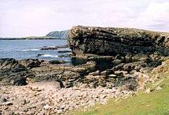 Hog of Breigeo, Ness of Burgi. This geo is typical of the rocky promontory of Ness of Burgi.
 Ness of Burgi fort Iron Age blockhouse at the Ness of Burgi. Sumburgh Head lighthouse in the distance
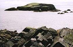 Horse Island from Hog of the Ness
References
Citations
- ↑ Map of Ness of Burgi.
- ↑ Ness of Burgi - RCAHMS.
- ↑ Uney 2010, p. 92-93.
Sources
- "Map of Ness of Burgi, Shetland Islands". Streetmap.co. Retrieved 2013-02-07.
- "Ness of Burgi". RCAHMS. Retrieved 2013-02-07.
- Uney, Graham (2010-09-09). Walking on the Orkney and Shetland Isles: 80 Walks in the Northern Isles. Cicerone Press Limited. ISBN 978-1-85284-572-8. Retrieved 2013-02-06.