Netarts Bay
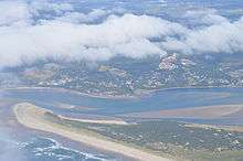

Netarts Bay is a bay on the northern Oregon Coast of the U.S. state of Oregon, located about 5 miles (8.0 km) southwest of Tillamook.
The bay is approximately 5 by 1.5 miles (8.0 by 2.4 km) and totals 2,325 acres (9.41 km2) in area, making it Oregon's seventh largest bay.[1] Of that, 812 acres (3.29 km2) are permanently submerged—the balance of 1,513 acres (6.12 km2) is intertidal land.[1] It experiences a tidal range of 6.8 feet (210 cm).
The bay is part of a watershed of 13 square miles (34 km2)[1] that is fed by at least 16 small creeks. From north to south, there is Fall Creek, Hodgdon Creek, O'Hara Creek, Rice Creek, two unnamed creeks, Yager Creek, three unnamed creeks, Whiskey Creek, an unnamed creek, Austin Creek, two unnamed creeks, and Jackson Creek.[2]
Layers of coarse sands and peat are below the soil along the coastline at Netarts Bay. Geologists have used this as evidence of significant earthquakes that have occurred in northwestern Oregon for more than 3,000 years. Tsunamis that resulted from the earthquakes deposited sediments from the ocean onto the coast.[3]
References
- 1 2 3 Advisory Committee to the State Land Board (July 1972). "An Inventory of Filled Lands in Netarts Bay Estuary" (pdf). Oregon State University Scholars Archive. p. 2. Retrieved 2008-07-25.
- ↑ ACME Mapper topomaps
- ↑ Bishop, Ellen Morris; Allen, John Eliot (1996). Hiking Oregon's geology. Seattle: The Mountaineers. pp. 62–63. ISBN 0-89886-485-2.
Coordinates: 45°24′09″N 123°56′40″W / 45.40250°N 123.94444°W