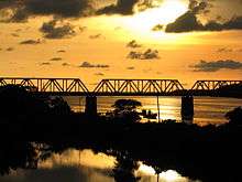
Netravati Bridge
| Netravati Bridge Ullal Bridge | |
|---|---|
 | |
| Coordinates | 12°50′21″N 74°51′36″E / 12.8391°N 74.8601°ECoordinates: 12°50′21″N 74°51′36″E / 12.8391°N 74.8601°E |
| Carries | 4 lanes of traffic, 2 way pedestrians |
| Crosses | Netravati River |
| Locale | Mangalore, Karnataka, India |
| Characteristics | |
| Total length | 804 metres (2,638 ft) |
| Height | 33.25 feet |
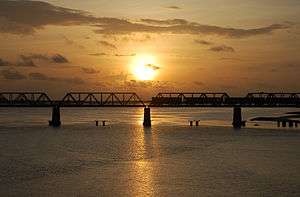
Netravati Bridge (ನೇತ್ರಾವತಿ ಸೇತುವೆ) is on NH 17 in Mangalore, Dakshina Kannada, Karnataka built over Netravati River, which connects Mangalore city with its southern suburbs Thokottu, Ullal and Deralakatte. This bridge is also called as Ullal Bridge as this bridge is located in the town called Ullal in Mangalore taluk.
The total length of this bridge is 830 meters.[1]
This bridge connects two states namely Karnataka and Kerala. As part of the national highway it was 2 lane wide. When the roads were widened, the additional bridge was built parallel to old bridge and it was released to public on 20 March 2014.[2]
The new bridge has a total of 24 pillars including 18 pillars amidst the water and 6 pillars alongside the river. The height of each pillar is 33.25 feet tall.
References
- ↑ "Netravati Bridge". in.geoview.info. Retrieved 2016-10-13.
- ↑ "Mangalore: New Netravati bridge opens to traffic, temporarily". www.daijiworld.com. Retrieved 2016-10-13.