Nevada State Route 266
| ||||
|---|---|---|---|---|
| Lida Road | ||||
 | ||||
| Route information | ||||
| Maintained by NDOT | ||||
| Length: | 40.338 mi[1] (64.918 km) | |||
| Existed: | 1976 – present | |||
| Major junctions | ||||
| West end: |
| |||
| East end: |
| |||
| Location | ||||
| Counties: | Esmeralda | |||
| Highway system | ||||
| ||||

State Route 266 (SR 266) is a 40.338-mile (64.918 km) state highway in Esmeralda County, Nevada, United States. It connects the routing of California State Route 266 east to U.S. Route 95 (US 95) via the town of Lida. Lida Road previously carried the southern end of State Route 3.
Route description
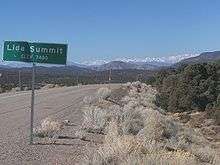
State Route 266 begins at the California state line about 4 miles (6.4 km) east of Oasis, California. From there, the highway makes its way east through the mountainous terrain and the Lida Summit (elevation 7,420 feet (2,260 m)) to the community of Lida.[2]
_in_Esmeralda_County%2C_Nevada.jpg)
Once it exits the town, the route continues east through the open desert. SR 266 reaches its eastern terminus at the Lida Junction, an intersection with US 95 14 miles (23 km) south of Goldfield. On the south side of the highway is the Lida Junction Airport—which was originally built to provide more convenient access to the now defunct Cottontail Ranch, located immediately southwest of the highway junction.
History
SR 266 originally began as the southernmost segment of State Route 3, one of Nevada's first four state highways designated with the creation of the Nevada Department of Highways in 1917.[3] Maps dating back to 1917 show SR 3 curving northward a few miles east of Lida on its trek towards Goldfield and points further north.[4] The eastern portion of the present-day route was constructed as a graded highway by 1937,[5] with the new alignment replacing the unimproved northeast leg by 1940.[6] The entire alignment was paved by 1960.[7]
SR 3 was officially eliminated from the state highway system as part of a mass renumbering of Nevada's state routes. State Route 266 was assigned to this former alignment of SR 3 on July 1, 1976.[8] The resulting change in the highway's number was first seen on the 1978–79 edition of the official highway map.[9]
Major intersections
The entire route is in Esmeralda County.
| Location | mi[10] | km | Destinations | Notes | |
|---|---|---|---|---|---|
| | 0.00 | 0.00 | Continuation beyond California state line | ||
| | |||||
| | 40.34 | 64.92 | |||
| 1.000 mi = 1.609 km; 1.000 km = 0.621 mi | |||||
See also
 Nevada portal
 U.S. Roads portal
References
- ↑ Nevada Department of Transportation (January 2016). "Nevada State Maintained Highways: Descriptions and Maps". Retrieved September 18, 2016.
- ↑ Official Highway Map of Nevada (Map) (2007-08 ed.). Nevada Department of Transportation. 2007. § E3.
- ↑ "Nevada Highway Maps – 1917–2005". Nevada in Maps. Mary B. Ansari Map Library, University of Nevada, Reno. 2008-12-11. Retrieved January 12, 2009.
- ↑ State Highway System of Nevada (Map). Nevada State Highway Department. 1917. Retrieved January 12, 2009.
- ↑ Official Road Map of the State of Nevada (Map). Nevada State Highway Department. 1937. Retrieved January 12, 2009.
- ↑ Official Road Map of the State of Nevada (Map). Nevada State Highway Department. 1940. Retrieved January 12, 2009.
- ↑ Official Highway Map of Nevada (Map). Nevada State Highway Department. 1960. § G3. Retrieved 2009-03-06.
- ↑ Nevada State Maintained Highways: Descriptions, Index and Maps. Nevada Department of Transportation. January 2001. p. 104.
- ↑ Official Highway Map of Nevada (Map) (1978-79 ed.). Nevada State Highway Department. 1978. § E2. Retrieved January 12, 2009.
- ↑ Nevada Department of Transportation (May 2008). "Maps of Milepost Location on Nevada's Federal and State Highway System by County" (PDF). Retrieved January 12, 2009.