New Boston, Illinois
| New Boston | |
| City | |
| Nickname: yellow banks | |
| Country | United States |
|---|---|
| State | Illinois |
| County | Mercer |
| Coordinates | 41°10′10″N 90°59′48″W / 41.16944°N 90.99667°WCoordinates: 41°10′10″N 90°59′48″W / 41.16944°N 90.99667°W |
| Area | 1.40 sq mi (4 km2) |
| - land | 0.93 sq mi (2 km2) |
| - water | 0.46 sq mi (1 km2) |
| Population | 683 (2010) |
| Density | 672.6/sq mi (260/km2) |
| Mayor | Chris Defrieze |
| Timezone | CST (UTC-6) |
| - summer (DST) | CDT (UTC-5) |
| Postal code | 61272 |
| Area code | 309 |
  Location of New Boston within Illinois | |
| Wikimedia Commons: New Boston, Illinois | |
New Boston is a city in Mercer County, Illinois, United States. The population was 683 at the 2010 census, up from 632 at the 2000 census.
Geography
New Boston is located at 41°10′10″N 90°59′48″W / 41.16944°N 90.99667°W (41.169570, -90.996709).[1]
According to the 2010 census, New Boston has a total area of 1.393 square miles (3.61 km2), of which 0.93 square miles (2.41 km2) (or 66.76%) is land and 0.463 square miles (1.20 km2) (or 33.24%) is water.[2]
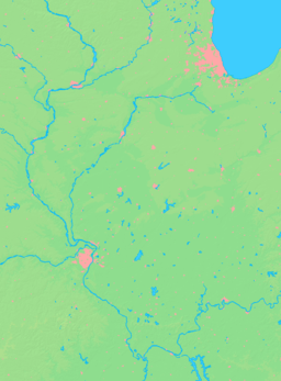
The city is located at the state line, across the river from Iowa.
New Boston is five miles south of Lock and Dam No. 17 on the Mississippi River. New Boston is located on the east bank of the Mississippi at the confluence of the Mississippi and Eliza Creek. Directly across the Mississippi is the mouth of the Iowa River. Much of the natural area surrounding New Boston is part of the Port Louisa National Wildlife Refuge. The river valley at New Boston is surrounded on both sides by gently rolling bluffs interspersed with rich parcels of wetlands that provide critical wildlife habitat; especially for migratory birds.[3]
Boston Bay is an area of water adjacent to the Mississippi River, at the mouth of Eliza Creek, to the north of New Boston. It is across the Mississippi from its confluence with the Iowa River.[4]
Demographics
| Historical population | |||
|---|---|---|---|
| Census | Pop. | %± | |
| 1850 | 229 | — | |
| 1860 | 583 | 154.6% | |
| 1870 | 779 | 33.6% | |
| 1880 | 633 | −18.7% | |
| 1890 | 445 | −29.7% | |
| 1900 | 703 | 58.0% | |
| 1910 | 718 | 2.1% | |
| 1920 | 714 | −0.6% | |
| 1930 | 736 | 3.1% | |
| 1940 | 801 | 8.8% | |
| 1950 | 767 | −4.2% | |
| 1960 | 726 | −5.3% | |
| 1970 | 706 | −2.8% | |
| 1980 | 731 | 3.5% | |
| 1990 | 620 | −15.2% | |
| 2000 | 632 | 1.9% | |
| 2010 | 683 | 8.1% | |
| Est. 2015 | 653 | [5] | −4.4% |
As of the census[7] of 2000, there were 632 people, 269 households, and 177 families residing in the city. The population density was 672.6 people per square mile (259.6/km²). There were 317 housing units at an average density of 337.4 per square mile (130.2/km²). The racial makeup of the city was 99.53% White, 0.16% African-American, 0.16% Native American, 0.16% from other races. Hispanic or Latino of any race were 0.32% of the population.
There were 269 households out of which 28.3% had children under the age of 18 living with them, 53.2% were married couples living together, 8.2% had a female householder with no husband present, and 34.2% were non-families. 29.0% of all households were made up of individuals and 12.3% had someone living alone who was 65 years of age or older. The average household size was 2.35 and the average family size was 2.92.
In the city the population was spread out with 23.1% under the age of 18, 9.3% from 18 to 24, 25.9% from 25 to 44, 24.5% from 45 to 64, and 17.1% who were 65 years of age or older. The median age was 40 years. For every 100 females there were 103.2 males. For every 100 females age 18 and over, there were 102.5 males.
The median income for a household in the city was $29,231, and the median income for a family was $36,875. Males had a median income of $32,361 versus $17,917 for females. The per capita income for the city was $15,593. About 6.4% of families and 11.2% of the population were below the poverty line, including 15.9% of those under age 18 and 11.7% of those age 65 or over.
Notable person
- Paul G. Blazer, first president and CEO of Ashland Inc.
References
- ↑ "US Gazetteer files: 2010, 2000, and 1990". United States Census Bureau. 2011-02-12. Retrieved 2011-04-23.
- ↑ "G001 - Geographic Identifiers - 2010 Census Summary File 1". United States Census Bureau. Retrieved 2015-12-27.
- ↑ http://www.fws.gov/midwest/PortLouisa/louisa.html
- ↑ Topozone
- ↑ "Annual Estimates of the Resident Population for Incorporated Places: April 1, 2010 to July 1, 2015". Retrieved July 2, 2016.
- ↑ "Census of Population and Housing". Census.gov. Retrieved June 4, 2015.
- ↑ "American FactFinder". United States Census Bureau. Retrieved 2008-01-31.
External links
Municipalities and communities of Mercer County, Illinois, United States | ||
|---|---|---|
| Cities | ||
| Villages | ||
| Townships | ||
| Unincorporated communities | ||
| Footnotes | ‡This populated place also has portions in an adjacent county or counties | |