New Fairfield, Connecticut
| New Fairfield, Connecticut | ||
|---|---|---|
| Town | ||
| ||
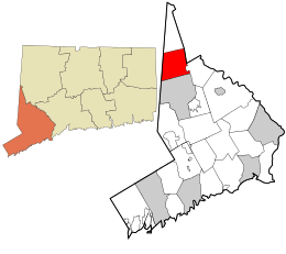 Location in Fairfield County and the state of Connecticut. | ||
| Coordinates: 41°29′N 73°29′W / 41.483°N 73.483°WCoordinates: 41°29′N 73°29′W / 41.483°N 73.483°W | ||
| Country | United States | |
| State | Connecticut | |
| NECTA | Danbury | |
| Region | Housatonic Valley | |
| Incorporated | 1740 | |
| Government | ||
| • Type | Selectman-town meeting | |
| • First selectman | Susan L. Chapman (R) | |
| • Selectman | Kim D. Hanson (R) | |
| • Selectman | Mike Gill (D) | |
| Area | ||
| • Total | 25.1 sq mi (65.0 km2) | |
| • Land | 20.5 sq mi (53.0 km2) | |
| • Water | 4.6 sq mi (11.9 km2) | |
| Elevation | 755 ft (230 m) | |
| Population (2010)[1] | ||
| • Total | 13,881 | |
| • Density | 550/sq mi (210/km2) | |
| Time zone | Eastern (UTC-5) | |
| • Summer (DST) | Eastern (UTC-4) | |
| ZIP code | 06812 | |
| Area code(s) | 203 | |
| FIPS code | 09-50860 | |
| GNIS feature ID | 0213469 | |
| Website | New Fairfield | |
New Fairfield is a town in Fairfield County, Connecticut, United States. The population was 13,881 at the 2010 census.[1] New Fairfield is one of five towns that surround Candlewood Lake, the largest lake in Connecticut.
History
In pre-colonial times, the indigenous people of New Fairfield were part of an alliance of tribes that extended from the source of the Housatonic to the sea.[2]
In 1724, colonial settlers from Fairfield, Connecticut received approval from the General Assembly of the Colony of Connecticut to establish a new township. According to one account, they negotiated with Chief Squantz of the Schaghticoke tribe of Algonquian lineage. Alternatively, it is told that they did not negotiate with Chief Squantz because he moved to the north end of Squantz Pond land area and refused to "sell" the township of New Fairfield. They returned in the Spring of 1725, but found that Chief Squantz had died during the winter. His four sons and heirs refused to sign the deeds. It was not until four years later that the white men called "The Proprietors" finally got the drawn marks of several other native people who may not have had authority to sell the land.[3] They "purchased" a 31,000 acre tract of land that is now New Fairfield and Sherman, for the equivalent of about 300 dollars and on April 24, 1729, The deed was recorded on May 9, 1729, and is now deposited in the archives of the state capital in Hartford, Connecticut.
In 1926, Connecticut Light and Power (CL&P) began construction on Candlewood Lake, considered by many to be an engineering wonder. CL&P flooded the valley to control the water flow from the Housatonic and Rocky Rivers and produce hydroelectric power for the region. Candlewood Lake was named for the Native American practice of using stripped wood from pine trees as kindling for fire. The lake shares its shores with the towns of New Fairfield, Sherman, New Milford, Brookfield, and Danbury. [4]
Geography
According to the United States Census Bureau, the town has a total area of 25.1 square miles (65 km2), of which 20.5 square miles (53 km2) is land and 4.6 square miles (12 km2), or 18.32%, is water. New Fairfield borders Danbury to the south, Brookfield to the southeast, New Milford to the northeast, Sherman to the north, and southeast, New York to the west.
There are four lakes in New Fairfield: Candlewood Lake, Squantz Pond, Ball Pond, and Margerie Reservoir. Candlewood Lake dominates the eastern side of the town and extends both north and south beyond the town borders. Once a summer resort destination, the lake within New Fairfield is now mostly populated with many year-round homes. To the north of New Fairfield, in the towns of Sherman and New Milford, the lakeshore still contains a large number of summer communities filled with residents from New York City and western New England.
Principal communities
- Ball Pond
- Candlewood Isle
- Candlewood Knolls
- Candlewood Shores
- Knollcrest
- New Fairfield center
Other minor named locales in the town are Bogus Hill, Candlewood Hills, Hillyview Drive, Hollywyle Park, Inglenook, Joyce Hill, Locust Glen, Sail Harbor, Possum Ridge, and Lavelle Avenue.
The newer communities with larger houses can be found in Sail Harbor. Many communities have large houses with direct waterfront access to Candlewood Lake, such as Sail Harbor, Candlewood Isle, and Bogus Hill. There has been many new subdivisions such as communities off Warwick Road, Route 39/37, Pine Hill, Beaver Bog, Dick Fin, and Shortwoods Road.
Attractions
- Cosier-Murphy House — 67 Route 39 (added to the National Register of Historic Places August 31, 1991)
- New Fairfield Historical District
- Squantz Pond State Park is partly in the town.
Schools
The New Fairfield Public Schools Systems includes four schools: Consolidated School, Meeting House Hill School, New Fairfield Middle School and New Fairfield High School. The middle and high schools are connected to one another.
Demographics
| Historical population | |||
|---|---|---|---|
| Census | Pop. | %± | |
| 1820 | 788 | — | |
| 1850 | 927 | — | |
| 1860 | 915 | −1.3% | |
| 1870 | 870 | −4.9% | |
| 1880 | 791 | −9.1% | |
| 1890 | 670 | −15.3% | |
| 1900 | 584 | −12.8% | |
| 1910 | 551 | −5.7% | |
| 1920 | 468 | −15.1% | |
| 1930 | 434 | −7.3% | |
| 1940 | 608 | 40.1% | |
| 1950 | 1,236 | 103.3% | |
| 1960 | 3,355 | 171.4% | |
| 1970 | 6,991 | 108.4% | |
| 1980 | 11,260 | 61.1% | |
| 1990 | 12,911 | 14.7% | |
| 2000 | 13,953 | 8.1% | |
| 2010 | 13,881 | −0.5% | |
| Est. 2014 | 14,149 | [5] | 1.9% |
As of the census[7] of 2000, there were 13,953 people, 4,638 households, and 3,905 families residing in the town. The population density was 681.9 people per square mile (263.3/km²). There were 5,148 housing units at an average density of 251.6 per square mile (97.1/km²). The racial makeup of the town was 96.83% White, 0.39% African American, 0.04% Native American, 1.27% Asian, 0.01% Pacific Islander, 0.52% from other races, and 0.95% from two or more races. Hispanic or Latino of any race were 2.82% of the population.
The 2000 census reported that New Fairfield was the most heavily Irish-American community in Connecticut, with about 32% of the residents claiming Irish ancestry
There were 4,638 households out of which 44.5% had children under the age of 18 living with them, 75.3% were married couples living together, 6.5% had a female householder with no husband present, and 15.8% were non-families. 12.6% of all households were made up of individuals and 5.0% had someone living alone who was 65 years of age or older. The average household size was 3.01 and the average family size was 3.30.
In the town the population was spread out with 30.0% under the age of 18, 5.1% from 18 to 24, 30.3% from 25 to 44, 25.9% from 45 to 64, and 8.6% who were 65 years of age or older. The median age was 37 years. For every 100 females there were 99.6 males. For every 100 females age 18 and over, there were 96.7 males.
The median income for a household in the town was $106,145, and the median income for a family was $132,271. Males had a median income of $65,978 versus $40,284 for females. The per capita income for the town was $34,928. About 1.0% of families and 1.7% of the population were below the poverty line, including 1.5% of those under age 18 and 4.7% of those age 65 or over.
According to a history of New Milford by Samuel Orcutt, the population of whites in New Fairfield in 1756 was 713.[8]
Education
The town has one high school, New Fairfield High School, one middle school for grades 6 through 8, New Fairfield Middle School, one elementary school for grades 3 to 5, Meeting House Hill School, a primary school for Kindergarten through grade 2, Consolidated School and two preschool/day care centers, Bright Beginnings and First Step PreSchool.
Zip code 06812
When ZIP codes were introduced in 1963, the original Danbury code, 06810, also covered the whole of New Fairfield. When Danbury received additional ZIP codes in 1984, a new code, 06812, was introduced for New Fairfield.
New Fairfield was home to the Candlewood Playhouse, a 650-seat summer stock theater run by the Gateway Playhouse, currently operating in Bellport, New York. The land once occupied by it is now a Stop and Shop supermarket.
Notable people
- Margot Austin (1907-1990), author illustrator.
- Mary Ann Carson, Connecticut State Representative.
- Steven Novella (1964–), Neurologist at Yale, Host of the Skeptics' Guide to the Universe.
- Jennifer Rizzotti (1974-), UCONN basketball player, who once was featured on the cover of Sports Illustrated
- Jay DePalma (1981-), bodybuilder, world-renowned Social Media Personality
YReferences
- 1 2 "Race, Hispanic or Latino, Age, and Housing Occupancy: 2010 Census Redistricting Data (Public Law 94-171) Summary File (QT-PL), New Fairfield town, Connecticut". U.S. Census Bureau, American FactFinder 2. Retrieved August 9, 2011.
- ↑ Silverberg, J. (June 1979). The History of Squantz Pond State Park, New Fairfield, CT. New Fairfield, Connecticut: manuscript from New Fairfield Free Public Library.
- ↑ Simon, Irving B. (1975). Our Town: The History of New Fairfield. New Fairfield, Connecticut: New Fairfield Bicentennial Commission. p. 5.
- ↑ Preserve New Fairfield, Inc. Images of America: New Fairfield. Charleston, SC: Arcadia Publishing, 2008. Print. p. 7-8
- ↑ "Annual Estimates of the Resident Population for Incorporated Places: April 1, 2010 to July 1, 2014". Retrieved June 4, 2015.
- ↑ "Census of Population and Housing". Census.gov. Retrieved June 4, 2015.
- ↑ "American FactFinder". United States Census Bureau. Retrieved 2008-01-31.
- ↑ Orcutt, Samuel. History of the Towns of New Milford and Bridgewater, Connecticut, 1703-1882.
External links
Municipalities and communities of Fairfield County, Connecticut, United States | ||
|---|---|---|
| Cities |  | |
| Towns | ||
| Borough | ||
| CDPs | ||
| Other communities | ||