New London, Connecticut
| City of New London | ||
|---|---|---|
| City | ||
|
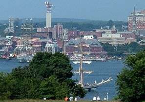
Downtown on the west bank of the Thames River | ||
| ||
| Nickname(s): The Whaling City | ||
| Motto: Mare Liberum | ||
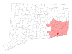 Location in New London County, Connecticut | ||
| Coordinates: 41°21′20″N 72°05′58″W / 41.35556°N 72.09944°W | ||
| Country | United States | |
| State | Connecticut | |
| Region | Southeastern Connecticut | |
| NECTA | Norwich-New London | |
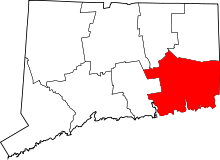
| County | New London County | |
| Settle | 1646 (Pequot Plantation) | |
| Named | 1658 (New London) | |
| Incorporated (city) | 1784 | |
| Government | ||
| • Type | Mayor-council | |
| • Mayor | Michael E. Passero (D) | |
| • City Council |
Erica Richardson. Michael Tranchida Efrain Dominguez Martha Marx Anthony Nolan John Satti Donald Venditto | |
| Area | ||
| • City | 10.76 sq mi (27.9 km2) | |
| • Land | 5.54 sq mi (14.3 km2) | |
| • Water | 5.23 sq mi (13.5 km2) | |
| • Urban | 123.03 sq mi (318.66 km2) | |
| Elevation | 56 ft (17 m) | |
| Population (2010) | ||
| • City | 27,620 | |
| • Density | 4,985/sq mi (1,824/km2) | |
| • Metro | 274,055 | |
| Time zone | EST (UTC-5) | |
| • Summer (DST) | EDT (UTC-4) | |
| ZIP code | 06320 | |
| Area code(s) | 860 | |
| FIPS code | 09-52280 | |
| GNIS feature ID | 0209237 | |
| Website | ||

New London is a seaport city and a port of entry on the northeast coast of the United States. It is located at the mouth of the Thames River in New London County, Southeastern Connecticut. New London is located about 47 miles (76 km) from the state capital of Hartford, 107 miles (172 km) from Boston, Massachusetts, 56 miles (90 km) from Providence, Rhode Island, 85 miles (137 km) from New Bedford, Massachusetts, and about 128 miles (206 km) from New York City.
For several decades beginning in the early 19th century, New London was one of the world's three busiest whaling ports, along with Nantucket and New Bedford, Massachusetts. The wealth that whaling brought into the city furnished the capital to fund much of the city's present architecture. New London subsequently became home to other shipping and manufacturing industries, but has gradually lost its commercial and industrial heart.[1] New London is now well known in Connecticut for its wealth of art and it's popular music scene.[2] The city is home to the United States Coast Guard Academy, Connecticut College, Mitchell College, and The Williams School. The Coast Guard Station New London and New London Harbor is home port to the U.S. Coast Guard Cutter Chinook and the Coast Guard's tall ship Eagle.
New London had a population of 27,620 at the 2010 census. The Norwich-New London metropolitan area (NECTA[3]) includes twenty-one towns[4] and 274,055 people.[5]
History
The area was called Nameaug by the Pequot Indians. John Winthrop, Jr. founded the first English settlement here in 1646, making it about the 13th town settled in Connecticut. Inhabitants informally referred to it as Nameaug or as Pequot after the tribe. In the 1650s, the colonists wanted to give the town the official name of London after London, England, but the Connecticut General Assembly wanted to name the town Faire Harbour. The citizens protested, declaring that they would prefer it to be called Nameaug if it couldn't be officially named London.[7][8] The legislature relented, and the town was officially named New London on March 10, 1658.
The harbor was considered to be the best deep water harbor on Long Island Sound,[9] and consequently New London became a base of American naval operations during the Revolutionary War. Famous New Londoners during the American Revolution include Nathan Hale, William Coit, Richard Douglass, Thomas & Nathaniel Shaw, Gen. Samuel Parsons, printer Timothy Green, and Samuel Seabury.
New London was raided and much of it burned to the ground on September 6, 1781 in the Battle of Groton Heights by Norwich native Benedict Arnold in an attempt to destroy the Revolutionary privateer fleet and supplies of goods and naval stores within the city. It is often noted that this raid on New London and Groton was to divert General Washington and the French Army under Rochambeau from their march on Yorktown, Virginia. The main defensive fort for New London was Fort Griswold, located across the Thames River in Groton. It was well known to Arnold, who sold its secrets to the British fleet so that they could avoid its artillery fire. After overrunning New London's Fort Trumbull, Ft. Griswold was attacked by the British, who suffered great casualties before eventually storming the fort and slaughtering many of the militia who defended it. All told, more than 52 British soldiers and 83 militia were killed, and more than 142 British and 39 militia were wounded, many mortally. New London suffered over 6 militia killed and 24 wounded, while Arnold and the British and Hessian raiding party suffered an equal amount.[10]
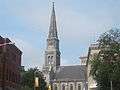 Historic First Congregational Church, United Church of Christ on State Street in New London – side photo taken from Citizens Bank
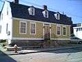 The Richard Douglass House on Green Street
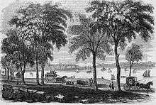
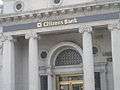 Citizen's Bank in New London
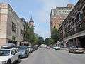 Another view of downtown New London
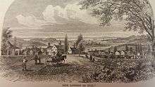
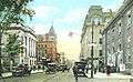 State Street (ca. 1920)
Connecticut's independent legislature made New London one of the first two cities brought from de facto to formalized incorporations in its January session of 1784, along with New Haven.
During the War of 1812, torpedoes were employed in attempts to destroy British vessels and protect American harbors. In fact, a submarine deployed torpedo was used in an unsuccessful attempt to destroy HMS Ramillies while in New London's harbor. This prompted the British Capt. Hardy to warn the Americans to cease efforts with the use of any "torpedo boat" in this "cruel and unheard-of warfare", or he would "order every house near the shore to be destroyed."[6]:693
For several decades beginning in the early 19th century, New London was one of the three busiest whaling ports in the world, along with Nantucket and New Bedford, Massachusetts. The wealth that whaling brought into the city furnished the capital to fund much of the city's present architecture.
The New Haven and New London Railroad connected New London by rail to New Haven and points beyond by the 1850s. The Springfield and New London Railroad connected New London to Springfield, Massachusetts by the 1870s.
Several military installations have been part of New London's history, including the United States Coast Guard Academy and Coast Guard Station New London.[11] Most of these military installations have been located at Fort Trumbull. The first Fort Trumbull was an earthwork built 1775-1777 that took part in the Revolutionary War. The second Fort Trumbull was built 1839-1852 and still stands. By 1910, the fort's defensive function had been superseded by the new forts of the Endicott Program, primarily located on Fishers Island. The fort was turned over to the Revenue Cutter Service and became the Revenue Cutter Academy. The Revenue Cutter Service was merged into the United States Coast Guard in 1915, and the Academy relocated to its current site in 1932. During World War II, the Merchant Marine Officers Training School was located at Fort Trumbull. From 1950 to 1990, Fort Trumbull was the location for the Naval Underwater Sound Laboratory, which developed sonar and related systems for US Navy submarines. In 1990, the Sound Laboratory was merged with the Naval Underwater Systems Center in Newport, Rhode Island, and the New London facility was closed in 1996.[12][13]
The Naval Submarine Base New London is physically located in Groton, but submarines were stationed in New London from 1951 to 1991. The submarine tender Fulton and Submarine Squadron Ten were at State Pier during this time. Squadron Ten was usually composed of ten submarines and was the first all-nuclear submarine squadron. In the 1990s, State Pier was rebuilt as a container terminal.
The family of Nobel laureate and Pulitzer Prize-winning playwright Eugene O'Neill (1888-1953) were intimately connected to New London. He lived here for years, and was employed as an adult and wrote his first seven or eight plays in the city. A major O'Neill archive is located at Connecticut College, and a family home in New London is a museum and registered national historic landmark operated by the Eugene O'Neill Theater Center. Dutch's Tavern on Green Street was a favorite watering hole of Eugene O'Neill and still stands today.
Towns created from New London
New London originally had a larger land area when it was established. Towns set off since include:
- Stonington in 1649
- This large area ran from the Mystic River to the Pawcatuck River, including Pawcatuck, Wequetequock, and the easterly half of Mystic. It stretched inland from Long Island Sound to Lantern Hill.
- Groton in 1705
- Ledyard (originally North Groton) created from a part of Groton in 1836
- Montville in 1786
- Salem created from parts of Montville, Colchester, and Lyme in 1819
- Waterford in 1801
- East Lyme created from parts of Waterford and Lyme in 1839
- Fishers Island officially left Connecticut and became part of New York in 1879.
Geography
In terms of land area, New London is one of the smallest cities in Connecticut. Of the whole 10.76 square miles (27.9 km2), nearly half is water; 5.54 square miles (14.3 km2) is land.[14]
The town and city of New London are coextensive. Sections of the original town were ceded to form newer towns between 1705 and 1801. The towns of Groton, Ledyard, Montville, and Waterford, and portions of Salem and East Lyme, now occupy what had earlier been the outlying area of New London.[15]
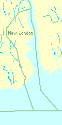
New London is bounded on the west and north by the town of Waterford, on the east by the Thames River and Groton, and on the south by Long Island Sound.
Principal communities
- Downtown
- Ocean Beach
Other minor communities and geographic features are: Bates Woods Park, Fort Trumbull, Glenwood Park, Green's Harbor Beach, Mitchell's Woods, Pequot Colony, Riverside Park, Old Town Mill.
Climate
New London, like the rest of coastal Connecticut, lies in the transition between a humid continental climate (Köppen climate classification: Dfa) and humid subtropical climate (Köppen Cfa), as is typical for much of the Tri-State Area (NY/NJ/CT). The city enjoys a sunny climate, averaging 2,600 hours of sunshine annually, and is the mildest large city in Connecticut in winter.
In the summer months, the southerly flow from subtropical high pressure (the Atlantic/Bermuda High) often creates hot and humid weather. Daytime heating produces occasional thunderstorms with heavy but brief downpours. Spring and Fall are mild in New London, with daytime highs in the 55 to 70 F range and lows in the 40 to 50 F range. The seaside geography allows a long growing season compared to areas inland. The first frost in the New London area is normally not until early November, almost three weeks later than parts of northern Connecticut. Winters are cool to cold with a mix of rainfall and snowfall, or mixed precipitation. New London normally sees fewer than 25 days annually with snow cover. In mid-winter, there can be large differences in low temperatures between areas along the coastline and areas well inland, often as much as 15 F.
Tropical cyclones (hurricanes/tropical storms) have struck Connecticut and the New London metropolitan area, although infrequently. Hurricane landfalls have occurred along the Connecticut coast in 1903, 1938, 1944, 1954 (Carol), 1960 (Donna), 1985 (Gloria). Tropical Storm Irene (2011) also caused moderate damage along the Connecticut coast, as did Hurricane Sandy (which made landfall in New Jersey) in 2012.
Coastal Connecticut (including New London) is the broad transition zone where so-called "subtropical indicator" plants and other broadleaf evergreens can successfully be cultivated. New London averages about 90 days annually with freeze, about the same as Baltimore, Maryland. As such, Southern Magnolias, Needle Palms, Windmill palm, Loblolly Pines, and Crape Myrtles are grown in private and public gardens. The growing season is quite long in New London, like much of coastal Connecticut and Long Island, NY, averaging 210 days from April 8 to November 5.
| Climate data for Sikorsky Airport (1981–2010 normals), ~74 mi (119 km) to the southwest, Snowfall data from NWS Norwich - 12 mi to the north. | |||||||||||||
|---|---|---|---|---|---|---|---|---|---|---|---|---|---|
| Month | Jan | Feb | Mar | Apr | May | Jun | Jul | Aug | Sep | Oct | Nov | Dec | Year |
| Average high °F (°C) | 37.1 (2.8) |
39.7 (4.3) |
47.2 (8.4) |
57.6 (14.2) |
67.6 (19.8) |
77.0 (25) |
82.1 (27.8) |
80.8 (27.1) |
74.0 (23.3) |
63.2 (17.3) |
53.1 (11.7) |
42.3 (5.7) |
60.1 (15.6) |
| Average low °F (°C) | 23.1 (−4.9) |
25.2 (−3.8) |
31.4 (−0.3) |
41.0 (5) |
50.5 (10.3) |
60.2 (15.7) |
66.3 (19.1) |
65.6 (18.7) |
58.0 (14.4) |
46.4 (8) |
37.9 (3.3) |
28.4 (−2) |
44.5 (6.9) |
| Average precipitation inches (mm) | 3.10 (78.7) |
2.79 (70.9) |
4.04 (102.6) |
4.13 (104.9) |
3.80 (96.5) |
3.64 (92.5) |
3.46 (87.9) |
3.96 (100.6) |
3.48 (88.4) |
3.64 (92.5) |
3.39 (86.1) |
3.33 (84.6) |
42.75 (1,085.9) |
| Average snowfall inches (cm) | 6.8 (17.3) |
5.7 (14.5) |
3.2 (8.1) |
.8 (2) |
0 (0) |
0 (0) |
0 (0) |
0 (0) |
0 (0) |
0 (0) |
.2 (0.5) |
4.8 (12.2) |
21.4 (54.4) |
| Average precipitation days (≥ 0.01 inch) | 10.9 | 9.7 | 11.3 | 11.0 | 11.8 | 11.1 | 8.9 | 8.9 | 8.2 | 8.8 | 10.0 | 11.1 | 121.7 |
| Average snowy days (≥ 0.1 inch) | 5.0 | 3.6 | 2.4 | .3 | 0 | 0 | 0 | 0 | 0 | 0 | .5 | 3.1 | 15.0 |
| Source: NOAA[16] | |||||||||||||
Demographics
| Historical population | |||
|---|---|---|---|
| Census | Pop. | %± | |
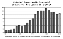
| 1800 | 5,150 | — | |
| 1810 | 3,238 | −37.1% | |
| 1820 | 3,330 | 2.8% | |
| 1830 | 4,335 | 30.2% | |
| 1840 | 5,519 | 27.3% | |
| 1850 | 8,991 | 62.9% | |
| 1860 | 10,115 | 12.5% | |
| 1870 | 9,576 | −5.3% | |
| 1880 | 10,537 | 10.0% | |
| 1890 | 13,757 | 30.6% | |
| 1900 | 17,548 | 27.6% | |
| 1910 | 19,659 | 12.0% | |
| 1920 | 25,688 | 30.7% | |
| 1930 | 29,640 | 15.4% | |
| 1940 | 30,456 | 2.8% | |
| 1950 | 30,551 | 0.3% | |
| 1960 | 34,182 | 11.9% | |
| 1970 | 31,630 | −7.5% | |
| 1980 | 28,842 | −8.8% | |
| 1990 | 28,540 | −1.0% | |
| 2000 | 25,671 | −10.1% | |
| 2010 | 27,620 | 7.6% | |
| Est. 2015 | 27,179 | [17] | −1.6% |
| U.S. Decennial Census | |||
Recent estimates on demographics and economic status
According to the 2006–2008 American Community Survey, non-Hispanic whites made up 54.6% of New London's population. Non-Hispanic blacks made up 14.0% of the population. Asians of non-Hispanic origin made up 4.6% of the city's population. Multiracial individuals of non-Hispanic origin made up 4.3% of the population; people of mixed black and white ancestry made up 1.7% of the population. In addition, people of mixed black and Native American ancestry made up 1.0% of the population. People of mixed white and Native American ancestry made up 0.7% of the population; those of mixed white and Asian ancestry made up 0.4% of the populace. Hispanics and Latinos made up 21.9% of the population, of which 13.8% were Puerto Rican.[18]
The top five largest European ancestry groups were Italian (10.5%), Irish (9.7%), German (7.4%), English (6.8%) and Polish (5.0%)
According to the survey, 74.4% of people over the age of 5 spoke only English at home. Approximately 16.0% of the population spoke Spanish at home.[19]
In 2012, the population reached 27,700. The median household income was $44,100, with 20% of the population below the poverty line.
2000 census
As of the census[20] of 2000, there were 25,671 people, 10,181 households, and 5,385 families residing in the city. The population density was 4,635.5 per square mile (1,789.8/km2). There were 11,560 housing units at an average density of 2,087.4 per square mile (805.9/km2). The racial makeup of the city was 63.49% White, 19.71% Hispanic or Latino of any race, 18.64% African American, 0.88% Native American, 2.12% Asian, 0.08% Pacific Islander, 9.13% from other races, and 5.67% from two or more races.
There were 10,181 households out of which 27.6% had children under the age of 18 living with them, 30.4% were married couples living together, 17.8% had a female householder with no husband present, and 47.1% were non-families. 37.8% of all households were made up of individuals and 10.7% had someone living alone who was 65 years of age or older. The average household size was 2.26 and the average family size was 3.00.
In the city the population was spread out with 22.8% under the age of 18, 17.6% from 18 to 24, 29.6% from 25 to 44, 17.9% from 45 to 64, and 12.1% who were 65 years of age or older. The median age was 31 years. For every 100 females there were 95.5 males. For every 100 females age 18 and over, there were 93.8 males.
The median income for a household in the city was $33,809, and the median income for a family was $38,942. Males had a median income of $31,405 versus $25,426 for females. The per capita income for the city was $18,437. About 13.4% of families and 15.8% of the population were below the poverty line, including 23.5% of those under age 18 and 11.4% of those age 65 or over.
Infrastructure
Transportation
By land, New London is almost exactly midway between New York City and Boston. The major seaboard interstate highway, I-95, passes through the city, and New London's Amtrak station is on the passenger rail Northeast Corridor. The city of Worcester, Massachusetts is 74 mi (119 km) northward, principally via Interstate 395, and the Connecticut capital, Hartford, is 53 mi (85 km) to the northwest and reachable via several different state highways (principally CT-2 and CT-9). New Haven is 47 mi (76 km) to the west along I-95.
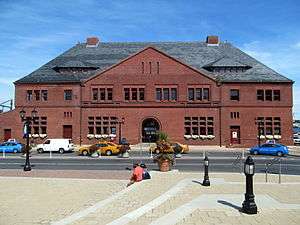
New London Union Station is served by Amtrak's Northeast Regional and Acela Express regional rail services, plus Shore Line East (SLE) commuter rail service. Downtown New London is also served by local taxi companies, regional Southeast Area Transit buses, interstate Greyhound Lines buses, the Cross Sound Ferry to Long Island, the Fishers Island Ferry District, and in summer by the Block Island Express ferry. In 2010, the Estuary Transit District began public transit service between the New London transportation center and Old Saybrook.
The Groton-New London Airport is located in neighboring Groton, and two major airports – T. F. Green and Bradley International Airport are within 75 minutes driving time, as is the smaller Tweed New Haven Regional Airport.
Rail freight is by the Providence & Worcester Railroad and the New England Central Railroad. Seagoing cargo at the State Pier is handled by Logistec Corporation.
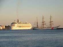
New London is also occasionally visited by cruise ships.[21]
Fire department
The city of New London has 56 firefighters and EMTs in the New London Fire Department(NLFD). Established in 1786, the NLFD currently operates out of 3 Fire Stations, located throughout the city, under the command of a Battalion Chief per shift. The New London Fire Department also operates a fire apparatus fleet of 3 Engines, 2 Trucks, 2 Ambulances, 1 Fire Investigation Unit, 1 Canteen Unit, and several other special, support, and reserve units. The NLFD currently responds to approximately 6,600 emergency calls annually.[22][23][24]
Fire station locations and apparatus
| Engine Company | Truck Company | Ambulance | Special Unit | Command Unit | Address |
|---|---|---|---|---|---|
| Engine 11 | Ambulance 100 | Fire Investigation Unit | Battalion Chief | 289 Bank St. | |
| Engine 21 | Truck 25 | Ambulance 200 | Haz-Mat./Decon. Unit | 240 Broad St. | |
| Engine 31 | Truck 35 (Spare) | Ambulance 400 (Spare) | 25 Lower Blvd. |
Local government
New London recently changed their form of government from council-manager to Strong Mayor-Council after a charter revision. Distinct town and city government structures formerly existed, and technically continue. However, they now govern exactly the same territory, and have elections on the same ballot on Election Day in November, the first Tuesday after the first Monday, of odd-numbered years; the officials of town and city interact essentially as do the officials of a single town or city who have different but related responsibilities and powers.
Recent policy challenges
- Jordan v. New London (2000)
On August 23, 2000, the United States Court of Appeals for the Second Circuit decided in Jordan v. New London that "prevent[ing] frequent job turnover caused by hiring overqualified applicants" was legal grounds for disqualifying an applicant seeking a job with the New London Police.[25] Plaintiff Robert Jordan took the Wonderlic Personnel Test as part of the city's application process; his score on that test was above the range required by the police department to legally narrow down the list of who qualify to take the next step in the application process. According to the city, Jordan was too smart to join the police since, in their experience, his intelligence correlated with an increased risk of job dissatisfaction, which in turn led to increased costs in hiring and training.
- Kelo v. New London (2005) / Fort Trumbull neighborhood
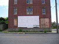
The neighborhood of Fort Trumbull, consisting of about 20 single- and multi-family homes built in the early 20th Century, was demolished in the late 2000s as part of a plan for the economic development of New London. The plan was appealed in a lawsuit that reached the US Supreme Court in 2005, Kelo v. City of New London, which was won by the city. Although the site was to be redeveloped under a Municipal Development Plan or MDP, this has not occurred as of 2014. The desolate landscape of the Fort Trumbull area is considered by many to be a stark example of government overreach and inefficiency.[26][27]
The Fort Trumbull Municipal Development Plan (MDP), approved in 2000, was one of the largest redevelopment projects in the history of the City of New London. The MDP area encompassed approximately 35 acres of development project sites that range from one to seven acres in size, within a total project area of more than 80 acres. The Fort Trumbull District/MDP area is approximately one mile from New London’s Historic Downtown Waterfront District.
There were two catalysts for the Fort Trumbull Project: the 1996 U.S. Navy closure announcement for the 32-acre Naval Undersea Warfare Center (NUWC) facility at Fort Trumbull, and the 1997 announcement by Pfizer Inc. that they would be developing their Global Research and Development Headquarters on an abandoned 24-acre mill site adjacent to and immediately south of the Fort Trumbull area.
On February 22, 2005, the United States Supreme Court ruled on the case of Kelo v. City of New London in a 5-4 vote, determining that the city may seize privately owned real property under eminent domain so that it could be used for private economic development. The justices decided that the tax revenue from the private development satisfied the requirement for public interest for eminent domain. The case was centered around pharmaceutical company Pfizer's efforts to construct a mixed-use complex that included a condominium, hotel, conference center, health club, and stores on the site of private homes in New London's Fort Trumbull neighborhood, in conjunction with a research facility that Pfizer was building nearby. Local homeowners including Susette Kelo challenged this development proposal on the grounds that their properties were being seized for private use, rather than public use, which was inconsistent with the Fifth Amendment of the U.S. Constitution's Bill of Rights: "...nor shall private property be taken for public use, without just compensation."[26][27]
In spite of the city's legal victory, the MDP never got off the ground. The city's chosen redeveloper was not able to get financing for the project.[28] Even though the city expended over eighty million dollars acquiring and demolishing homes, the area where the taken homes once stood remained vacant (as of 2015).[29] In November, 2009, Pfizer announced that they were closing their facility adjacent to the site and moving those operations across the Thames River to their site in Groton.[30][31] The New London campus was sold to General Dynamics in 2010, who have established design offices at the site.[28]
New London Main Street is a non-profit civic organization founded in 1998, devoted to the New London Historic Waterfront District. It runs programs that promote the district's cultural and economic vitality and also campaigns for various initiatives to keep and enhance the district's streetscapes. All of the group's efforts are put toward the preservation of its neighborhood.
Arts and culture
Music
New London has a respected symphony orchestra, a military wind ensemble, and a local tradition of R&B and rock-n-roll. Notable artists and ensembles include:
- Eastern Connecticut Symphony Orchestra, founded in 1946 and led by Toshiyuki Shimada, who is also conductor of the Yale Symphony Orchestra in New Haven.
- The Idlers of the United States Coast Guard Academy, an all-male vocal group specializing in sea shanties and patriotic music.
- United States Coast Guard Band, founded in 1925 with the assistance of John Philip Sousa. Stationed at the United States Coast Guard Academy and attracting talented musicians from all parts of the country, the band is the official musical representative of the nation's oldest continuous seagoing service.
- The Can Kickers, a folk punk band.
- Dawn Robinson, a R&B singer.
Sites of interest
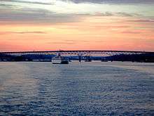 New London from the harbor
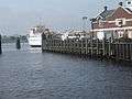 From the waterfront in New London ferry service is available to Fishers Island
.JPG) Downtown New London (2009)
Downtown New London (2009)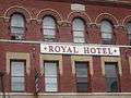 Royal Hotel downtown
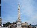 Civil War Monument in downtown New London
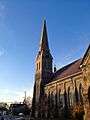 Former Second Cong. Church, Broad St.[32]
- Ye Antientist Burial Ground
- Hygienic Arts[33]
- Connecticut College Arboretum
- Coast Guard Station New London
- Flock Theatre[34]
- Fort Griswold (Groton)
- Fort Trumbull
- Garde Arts Center[35]
- Joshua Hempsted House (1678)[36]
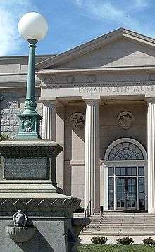
- Lyman Allyn Art Museum
- Monte Cristo Cottage & Eugene O'Neill Theater Center (Waterford)[37]
- Ocean Beach Park[38]
- Olde Town Mill aka Winthrop Mill (1650)
- Former Second Congregational Church (1870)[39]
- New London County Historical Society – Shaw-Perkins Mansion (1758)[40]
- New London Maritime Society – U.S. Custom House (1833),[41] landing site of Amistad (1839)
- Fishers Island (7 miles off the coast of New London, but currently part of New York).[42]
Notable people
- Eliphalet Adams (1677–1753), clergyman
- Theresa Andrews (born 1962), winner of two Olympic gold medals.
- Peter C. Assersen (1839–1906), Rear Admiral in the United States Navy
- James Avery (1620–1700), politician and military commander
- Nathan Belcher (1813–1891), congressman
- Augustus Brandegee (1828–1904), judge, congressman, abolitionist
- Frank B. Brandegee (1864–1924), congressman and senator
- Amy Brenneman (born 1964), actress
- Henry Burbeck (1754–1848), brigadier general
- Daniel Burrows (1756–1858), congressman
- Harry Daghlian (1921–1945), physicist at Los Alamos National Lab, first person to die as a result of a criticality accident.
- David Dorfman (born 1955), choreographer
- Richard Douglass (1746–1828), cooper and soldier
- Doug DuBose (born 1964), NFL player
- Kris Dunn (born 1994), college basketball player for the Providence College Friars.
- Larry Elgart (born 1922), musician
- John Ellis (born 1948), baseball player
- Richard P. Freeman (1869–1944), congressman
- L. Patrick Gray (1916–2005), lawyer and Watergate figure
- Nathan Hale (1755–1776), schoolmaster and patriot
- Doc Hammer (born 1967), multimedium artist and co-creator of the Venture Brothers
- Matt Harvey (born 1989), MLB pitcher for the New York Mets
- Glenne Headly (born 1955), actress
- Barkley L. Hendricks (born 1945), painter
- Linda Jaivin (born 1955), Australian author[43]
- Sarah Kemble Knight (1666–1727), diarist, teacher and businesswoman
- John Law (1796–1873), congressman
- Bryan F. Mahan (1856–1923), congressman
- Richard Mansfield (1857–1907), actor
- John McCain (born 1936), senator and Republican presidential nominee (lived in New London as a child when his father, John S. McCain, Jr., worked at the naval submarine base)
- Thomas Minor (1608–1690), founder and early New England diarist
- Casey Neistat (born 1981), filmmaker
- James O'Neill (1847–1920), actor, father of Eugene O'Neill
- Eugene O'Neill (1888–1953), playwright
- Walter Palmer (1585–1661), founder
- Elias Perkins (1767–1845), congressman
- Mary Philips (1901–1975), actress
- Edward Clark Potter (1857–1923), sculptor
- Art Quimby (1933–2010), basketball player
- Jordan Reed (born 1990), tight end for the Washington Redskins
- Tim Riordan (born 1960), gridiron football player
- Dawn Robinson (born 1965), singer
- Dudley Saltonstall (1738–1796), naval officer
- "Magic Dick" Salwitz (born 1945), musician
- Thomas R. Sargent III (1914–2010), Vice Admiral in the United States Coast Guard
- Samuel Seabury (1729–1796), bishop
- Benjamin Stark (1820–1898), senator
- Dana Suesse (1909–1987), composer, songwriter, musician
- Ron Suresha, author and editor
- Cassie Ventura (born 1986), singer
- John T. Wait (1811–1899), former U.S. Representative for Connecticut[44]
- Thomas M. Waller (1839–1924), Mayor of New London and 51st Governor of Connecticut
- John Winthrop the Younger (1606–1676), statesman and founder
- Tyson Wheeler (born 1975), former Denver Nuggets basketball player[45]
- Abisha Woodward (1752–1809), early American lighthouse builder[46]
References
- ↑ Downey, Kirstin (May 22, 2005). "Nation & World | Supreme Court ruling due on use of eminent domain". Seattle Times. Retrieved October 28, 2011.
- ↑ "Welcome to New London, Connecticut - Home". www.ci.new-london.ct.us. Retrieved 2016-10-03.
- ↑ "About Metropolitan and Micropolitan Statistical Areas". Census.gov. August 19, 2008. Retrieved October 28, 2011.
- ↑
- ↑ "CBSA 01". Census.gov. Archived from the original on March 11, 2007.
|archive-url=is malformed: timestamp (help) - 1 2 Lossing, Benson (1868). The Pictorial Field-Book of the War of 1812. Harper & Brothers, Publishers. p. 692.
- ↑ Richard B. Marrin (1 January 2007). Abstracts from the New London Gazette Covering Southeastern Connecticut, 1763-1769. Heritage Books. p. 242. ISBN 978-0-7884-4171-4.
- ↑ Frances Manwaring Caulkins, History of New London, Connecticut, from the first survey of the coast in 1612 to 1860, Library of Congress, 1895.
- ↑ "1911 Encyclopædia Britannica". 1911encyclopedia.org. September 4, 2006. Retrieved October 28, 2011.
- ↑ "The Battle of Groton Heights & Burning of New London". Battleofgrotonheights.com. August 31, 2006. Retrieved October 28, 2011.
- ↑ Coast Guard Station New London official web page
- ↑ The History of Fort Trumbull by John Duchesneau
- ↑ Fort Trumbull History Site
- ↑ "New London County, Connecticut – County Subdivision and Place". American FactFinder. United States Census Bureau. Retrieved October 28, 2011.
- ↑ Archived March 14, 2008, at the Wayback Machine.
- ↑ "NowData - NOAA Online Weather Data". National Oceanic and Atmospheric Administration. Retrieved 2011-12-28.
- ↑ "Annual Estimates of the Resident Population for Incorporated Places: April 1, 2010 to July 1, 2015". Retrieved July 2, 2016.
- ↑ "New London city, Connecticut – ACS Demographic and Housing Estimates: 2006–2008". American FactFinder. United States Census Bureau. Retrieved October 28, 2011.
- ↑ "New London city, Connecticut – Selected Social Characteristics in the United States: 2006–2008". American FactFinder. United States Census Bureau. Retrieved October 28, 2011.
- ↑ "American FactFinder". United States Census Bureau. Archived from the original on September 11, 2013. Retrieved 2008-01-31.
- ↑ 2010. Connecticut's Port of New London. The Connecticut Cruise Ship Task Force, Inc.
- ↑ "City of New London, Connecticut - Firefighting Division". Ci.new-london.ct.us. Retrieved 2013-07-10.
- ↑ "City of New London, Connecticut - Ambulance Division". Ci.new-london.ct.us. Retrieved 2013-07-10.
- ↑ "City of New London, Connecticut - History". Ci.new-london.ct.us. Retrieved 2013-07-10.
- ↑ "Jordon v. New London". AELE Law Enforcement Legal Center. August 23, 2000. Retrieved 2012-11-29.
- 1 2 Jacoby, Jeff, "Eminent disaster: Homeowners in Connecticut town were dispossessed for nothing," The Boston Globe, March 12, 2014
- 1 2 Cornell Law School, Fifth Amendment, http://www.law.cornell.edu/wex/fifth_amendment
- 1 2 Allen, Charlotte (Feb 10, 2014). "'Kelo' Revisited". Weekly Standard. Retrieved 23 October 2014.
- ↑ Somin, Ilya The story behind Kelo v. City of New London – how an obscure takings case got to the Supreme Court and shocked the nation. The Washington Post, May 29, 2015.
- ↑ "Pfizer and Kelo's Ghost Town". The Wall Street Journal. November 11, 2009. p. A20.
Pfizer bugs out, long after the land grab.
- ↑ "A 'wrong turn': From giddy optimism to stunning disappointment". The Day. November 11, 2009.
- ↑ Baldelli, Ann (24 December 2014). "New Awakening: Congregation left legacy building to find solvency". The Day. The Day Publishing Company, New London, CT. Retrieved 29 December 2014.
- ↑ Hygienic Arts
- ↑ Flock Theatre
- ↑ Garde Arts Center
- ↑ Joshua Hempsted House Connecticut Landmarks
- ↑ Eugene O'Neill Theater Center
- ↑ Ocean Beach Park
- ↑ Morrison, Betty Urban (1985). The Church on the Hill: A history of the Second Congregational Church, New London, Connecticut 1835-1985. New London, Connecticut: Second Congregational Church. p. 17.
- ↑ New London Historical Society
- ↑ New London Maritime Society
- ↑ Fishers Island
- ↑ Bio, Linda Jaivin's web site
- ↑ "WAIT, John Turner, (1811 - 1899)". Biographical Directory of the United States Congress. Retrieved October 10, 2012.
- ↑ Keefe, Gavin (March 20, 2015). "Wheeler on Dunn: New London basketball legend talks about legend-to-be". The New London Day. Retrieved August 13, 2015.
- ↑ Griswold, Wick (2012). A History of the Connecticut River. The History Press. pp. 96–97. ISBN 9781609494056. Retrieved April 13, 2016.
External links
| Wikimedia Commons has media related to New London, Connecticut. |
| Wikivoyage has a travel guide for New London, Connecticut. |
| Wikisource has the text of The New Student's Reference Work article New London, Ct.. |
- City of New London, Connecticut
- New London Main Street
- Greater Mystic, Connecticut Region
- Public Library of New London
- Amistad: Seeking Freedom in Connecticut – National Park Service
- Fort Trumbull History Site
- The History of Fort Trumbull by John Duchesneau
- Historic American Engineering Record (HAER) No. CT-141, "Connecticut State Pier, State Pier Road at Thames River, New London, New London County, CT", 22 photos, 14 data pages, 3 photo caption pages
Coordinates: 41°21′15″N 72°06′04″W / 41.354069°N 72.10104°W
| Topics | |||||||||||
|---|---|---|---|---|---|---|---|---|---|---|---|
| States | |||||||||||
| Major cities | |||||||||||
| State capitals | |||||||||||
| Transportation |
| ||||||||||
| |||||||||||