New York City Farm Colony
The New York City Farm Colony was a poorhouse on the New York City borough of Staten Island, one of the city's five boroughs. It was located across Brielle Avenue from Seaview Hospital, on the edge of the Staten Island Greenbelt.

History
Part of the town of Castleton from the 1680s onward, the land was taken over by the government of Richmond County in 1829 and the Richmond County Poor Farm was established thereon. When Staten Island became a borough of New York City in 1898, the city assumed responsibility for the property and redesignated it the New York City Farm Colony, although it was sometimes also referred to as the Staten Island Farm Colony. In 1915, its administration was merged with that of Seaview Hospital, which had been set up with the expressed purpose of treating tuberculosis (it is now a city-run nursing home, under the new name of Sea View Farms).[1]
Jurisdiction over the site was transferred in 1924 to the city's Homes for Dependents agency, which lifted the requirement that all residents of the colony had to work — with most of the work involving the cultivation of many varieties of fruits and vegetables, and at various times even grains such as wheat and corn; these crops fed not only the colony's residents but met the needs of other city institutions as well.[1]
Until the 1930s, many if not most of the farm colony's residents were elderly, and at times numbered as many as 2,000; this number steadily declined after the Social Security system was adopted on the federal level in the United States (although noted photographer Alice Austen lived there for a brief period in the early 1950s[2]), and the programs of the Great Society implemented in the 1960s further depleted its ranks, leading to the facility being closed in 1975.
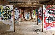
Since its closure, the Farm Colony site has been the focus of debate over land use. In 1980 the city attempted to sell the property to developers, but environmentalists and many Staten Islanders resisted the sale. As a result, in 1982, the city's Department of General Services was given authority over the land; this agency in turn transferred 25 acres (101,000 m²) to the New York City Department of Parks and Recreation, which annexed the section to the Greenbelt. The remaining 70 acres (283,000 m²) at the site were officially designated a city landmark in 1985; many buildings remain standing at the colony, but have fallen into disrepair and have also been subjected to vandalism.[1]
In 1983, a Babe Ruth League baseball diamond was built on Farm Colony land; a second field was added in 2001.
Fire and EMS response
Primary Fire response and suppression falls on the Fire Department of the City Of New York (FDNY), however a small volunteer fire company called Metropolitan Fire ("Metro Fire") is located on the grounds of SeaView. Metro Fire volunteer firefighters use a Seagrave pumper truck, a Mack pumper truck, and a Ford van to respond to incidents in the historic SeaView Farm colony.
A volunteer ambulance company called "Volunteer Heart Ambulance" is also headquartered in the Seaview Colony
References
- 1 2 3 Gray, Christopher. "Streetscapes: The Farm Colony; 'Historic' or Not, It's a Jungle in There", The New York Times, September 22, 1991. Accessed November 26, 2008.
- ↑ Raynor, Vivian. "ART; Never Without Her Camera ", The New York Times, July 14, 1991. Accessed November 26, 2008.
Coordinates: 40°35′37″N 74°08′19″W / 40.59361°N 74.13861°W
External links
- Photographs From Inside the New York City Farm Colony. Atlas Obscura