New York State Route 406
| ||||
|---|---|---|---|---|
|
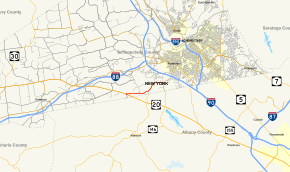
Map of Schenectady County in eastern New York with NY 406 highlighted in red | ||||
| Route information | ||||
| Maintained by NYSDOT | ||||
| Length: | 3.60 mi[1] (5.79 km) | |||
| Existed: | mid-1930s[2][3] – present | |||
| Major junctions | ||||
| West end: |
| |||
| East end: |
| |||
| Location | ||||
| Counties: | Schenectady | |||
| Highway system | ||||
| ||||

New York State Route 406 (NY 406) is a state highway in Schenectady County, New York, in the United States. The western terminus of the route is at an intersection with U.S. Route 20 (US 20) in the town of Princetown. Its eastern terminus is at a junction with NY 158 in the town of Rotterdam. NY 406 is a two-lane highway and known as Giffords Church Road along its entire length. It was assigned to its current alignment in the mid-1930s.
Route description

NY 406 begins at an intersection with US 20 (Western Turnpike) in the Princetown hamlet of Gifford. The route progresses eastbound past the Hillcrest Golf Club as Giffords Church Road, paralleling US 20 to the north until an intersection with Parkers Corners Road (County Route 60 or CR 60). There it turns northeast, intersecting with Windy Hill Road (CR 99), a north–south road leading to CR 60. NY 406 continues northeastward through farmlands, intersecting with Quackenbush Road (CR 62) on its way into the town of Rotterdam, where the route passes to the south of Schenectady Memorial Park in the hamlet of Pine Grove. The route ends just east of the park at a junction with NY 158 (Guilderland Avenue).[4]
History
The origins of NY 406 date back to January 3, 1922, when the Schenectady County Board of Supervisors passed a resolution expressing the county's desire to have the state of New York reconstruct the road as a state highway. At the same time, the board withdrew the county's support for a state project to rebuild part of what is now NY 147 in order to offset the mileage gained by adding Giffords Church Road to the state highway system. The changes required the approval of the New York State Department of Highways,[5] which rejected the proposal by January 11.[6] Despite this fact, Giffords Church Road was taken over by the state of New York by 1926[7] and designated NY 406 at some point between 1933 and 1936.[2][3]
Major intersections
The entire route is in Schenectady County.
| Location | mi[1] | km | Destinations | Notes | |
|---|---|---|---|---|---|
| Princetown | 0.00 | 0.00 | Hamlet of Gifford | ||
| Town of Rotterdam | 3.60 | 5.79 | |||
| 1.000 mi = 1.609 km; 1.000 km = 0.621 mi | |||||
See also
.svg.png) New York Roads portal
New York Roads portal
References
- 1 2 "2008 Traffic Data Report for New York State" (PDF). New York State Department of Transportation. June 16, 2009. p. 308. Retrieved January 10, 2010.
- 1 2 Texaco Road Map – New York (Map). Cartography by Rand McNally and Company. Texas Oil Company. 1933.
- 1 2 New York (Map). Cartography by General Drafting. Standard Oil Company. 1936.
- ↑ Microsoft; Nokia (February 16, 2012). "overview map of NY 406" (Map). Bing Maps. Microsoft. Retrieved February 16, 2012.
- ↑ "New Board Would Change Highway Plans for County". Schenectady Gazette. January 4, 1922. p. 5.
- ↑ "Federal Trucks for County Highway Use". Schenectady Gazette. January 11, 1922. p. 13.
- ↑ Official Map Showing State Highways and other important roads (Map). Cartography by Rand McNally and Company. State of New York Department of Public Works. 1926.
External links
| Wikimedia Commons has media related to New York State Route 406. |
- New York State Route 406 at New York Routes • New York State Highway Termini