New York State Route 440
| ||||
|---|---|---|---|---|
|
Map of Staten Island in New York City with NY 440 highlighted in red | ||||
| Route information | ||||
| Maintained by NYSDOT and PANYNJ | ||||
| Length: | 12.73 mi[1] (20.49 km) | |||
| Existed: | 1949[2] – present | |||
| Major junctions | ||||
| South end: |
| |||
|
| ||||
| North end: |
| |||
| Location | ||||
| Counties: | Richmond | |||
| Highway system | ||||
| ||||

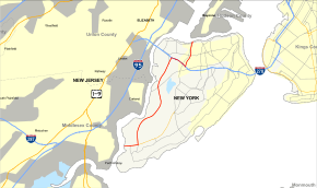
New York State Route 440 (NY 440) is a state highway located entirely on Staten Island in New York City. The route acts as a connector between the two segments of New Jersey Route 440, running from the Staten Island community of Richmond Valley to the south to Port Richmond to the north. NY 440 is connected to the two New Jersey segments by the Outerbridge Crossing to the south and the Bayonne Bridge to the north. It is one of several signed New York State routes that are not connected to any others in the state, and one of only two NYS routes (NY 426 being the other) that is the middle section of another state's highway bearing the same number. Much of NY 440 is a limited-access highway. From the Korean War Veterans Parkway to Interstate 278 (I-278), it is known as the West Shore Expressway. North of I-278, it is named the Dr. Martin Luther King Jr. Expressway (formerly the Willowbrook Expressway). NY 440 is the southernmost state route in the state of New York.
Route description
NY 440 begins at the New York–New Jersey state line, mid-span on the Outerbridge Crossing over the Arthur Kill in the Richmond Valley neighborhood of Staten Island. The four-lane bridge crosses east through Richmond Valley and over Arthur Kill Road.
After landing in Staten Island, NY 440 enters a toll barrier for eastbound traffic entering the city. Immediately following the toll barrier is a ramp to Page Avenue, the eastbound exit 1.
In the westbound direction, the ramp to Arthur Kill Road is exit 1.
After Page Avenue, NY 440 enters a partial cloverleaf interchange with the Korean War Veterans Parkway (formerly the Richmond Parkway) and a nearby park and ride. At exit 2 in Pleasant Plains, NY 440 exits the right-of-way it entered on, which becomes the Korean War Veterans Parkway, while NY 440 proceeds north on the West Shore Expressway.[3]
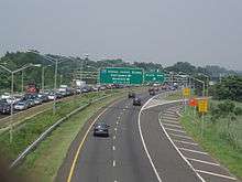
The West Shore Expressway continues north as a four-lane expressway, entering exit 3, a ramp to Woodrow Road going northbound. Crossing into Rossville, the expressway enters exit 3 southbound, connecting to Bloomingdale Road, and parallels a section of the Arthur Kill. Crossing north of South Shore Golf Course, the West Shore enters exit 4, an interchange with Huguenot Avenue. Entering the community of Fresh Kills, NY 440 crosses through the site of the former Fresh Kills Landfill near exit 5, which connects to Arden Avenue going southbound. Bending northward once again, the expressway crosses over Fresh Kills Main Creek and enters the William T. Davis Wildlife Refuge. Now in the Travis neighborhood. Here, the West Shore enters exit 7, a service road interchange with Victory Boulevard.[3]
Running along the northern end of Travis, the West Shore Expressway parallels nearby railroad tracks before entering exit 8, a ramp to South Avenue and Bloomfield. Just a bit further north, the expressway enters exit 9 northbound, a single ramp to Glen Street. Just north of Glen Street, the West Shore Expressway enters a semi-directional T interchange with the Staten Island Expressway (I-278). At this interchange, NY 440 and I-278 become concurrent for a short distance on the Staten Island Expressway, a four-lane expressway along the northern tier of Staten Island. Along this stretch, NY 440 and I-278 meet Richmond Avenue at exit 7. Just to the east, the expressway enters exit 9, which serves as a junction with the Dr. Martin Luther King Jr. Expressway (formerly the Willowbrook Expressway).[3]
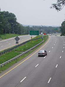
NY 440 turns off I-278 onto the Dr. Martin Luther King Expressway just north of a junction with Victory Boulevard. The expressway crosses north through Staten Island, entering exit 12, a junction with Forest Avenue. Crossing through Graniteville, NY 440 enters exit 13, which connects to Walker Street in Port Richmond. Just north of exit 13, NY 440 crosses onto the abutments of the Bayonne Bridge, condensing to four lanes. A short distance to the north, the expressway crosses the state line back into New Jersey, continuing north as NJ 440 and County Route 501 into the city of Bayonne.[3]
History
NY 440 was initially designated in 1949 as a continuation of New Jersey's Route 440.[2] The route began at the Outerbridge Crossing and ended at the Bayonne Bridge, as it does today; however, the route was originally routed on Drumgoole Boulevard and Richmond Avenue in between the two bridges.[4] In the early 1950s, proposals surfaced for the Willowbrook Parkway, which would extend from Staten Island Marine Park (later Great Kills Park and now part of the Gateway National Recreation Area) on the island's East Shore to the Bayonne Bridge via Egbertville and Bulls Head.[4][5] A second highway, the West Shore Expressway, was proposed c. 1961. As proposed, it would begin at the Outerbridge Crossing and run along the west shore of Staten Island to meet the Clove Lakes Expressway (I-278) near the Goethals Bridge.[6][7]
The first section of the Willowbrook Parkway—from I-278 north to modern exit 13—was completed by 1965.[8] A short extension south to Victory Boulevard was opened to traffic by 1968. The highway was also renamed the Willowbrook Expressway by this time.[9] It was never extended past Victory Boulevard as opposition from both local property owners and environmental activists prevented construction of the rest of the highway. Its original route has never been formally demapped, however.[10] NY 440 was realigned to follow the Willowbrook Expressway by 1970.[11]
Drumgoole Boulevard was transformed into a limited-access highway in the late 1960s and early 1970s[9][12] and renamed the Richmond Parkway (now the Korean War Veterans Parkway) c. 1973; however, NY 440 initially continued to follow the parkway. The segment of the West Shore Expressway southwest of Huguenot Avenue was opened c. 1973[12][13] and became part of a realigned NY 440 c. 1974. NY 440 left the expressway at Huguenot Avenue and followed Arthur Kill Road east to Richmond Avenue, where it continued north on its original alignment. The former alignment of NY 440 on the Richmond Parkway was redesignated as Temporary NY 440.[13][14] When the West Shore Expressway was completed in 1976,[2] the Temporary NY 440 designation was eliminated while NY 440 was shifted westward to follow the West Shore and Clove Lakes Expressways between Huguenot Avenue and the Willowbrook Expressway.[15]
In the mid-1960s, officials in New Jersey and New York considered extending the I-287 designation eastward from its current terminus at the New Jersey Turnpike (I-95) to Staten Island via New Jersey Route 440 and the Richmond Parkway. The idea was scrapped soon afterward.[16] In 1990, the Willowbrook Expressway was renamed the Dr. Martin Luther King Jr. Expressway in honor of Martin Luther King Jr, the slain civil rights leader.[10] The West Shore Expressway was ceremonially designated the Pearl Harbor Memorial Expressway by New York Governor George Pataki in 1999. However, the expressway's official name did not change.[17]
Exit list
The entire route is in the New York City borough of Staten Island.
| Location | mi[1] | km | Exit | Destinations | Notes |
|---|---|---|---|---|---|
| Arthur Kill | 0.00 | 0.00 | – | Continuation into New Jersey | |
| Richmond Valley | 1 | Page Avenue / Hylan Boulevard (north) / Arthur Kill Road (south) | |||
| 1.13 | 1.82 | 2 | Southern terminus of K.W.V. Parkway | ||
| Charleston | 3A | Englewood Avenue | Southbound exit and northbound entrance; opened September 30, 2014[18] | ||
| 3 | Woodrow Road (north) / Bloomingdale Road (south) | ||||
| Rossville | 3.73 | 6.00 | 4 | Arthur Kill Road / Huguenot Avenue | |
| Arden Heights | 5 | Muldoon Avenue / Arden Avenue | Southbound exit only | ||
| Fresh Kills | Bridge | ||||
| Travis | 6.37 | 10.25 | 7 | Victory Boulevard | Former routing of NY 439A |
| 7.29 | 11.73 | 8 | South Avenue | ||
| Bloomfield | 9 | Glen Street | Northbound exit only; opened in 2001[19] | ||
| 9.33 | 15.02 | 5 | Western terminus of concurrency with I-278 | ||
| 6 | South Avenue | Southbound exit and entrance | |||
| Graniteville | 9.54 | 15.35 | 7 | Richmond Avenue | Access via Fahy Avenue northbound |
| 10.24 | 16.48 | 8 | Victory Boulevard | Northbound exit and southbound entrance; former routing of NY 439A | |
| 10.43 | 16.79 | 9 10E | Eastern terminus of concurrency with I-278; signed as exit 9 northbound, exit 10E southbound | ||
| 10.43 | 16.79 | 10W | Northbound exit and southbound entrance | ||
| 11 | Victory Boulevard | Southbound exit and northbound entrance; former routing of NY 439A | |||
| 11.41 | 18.36 | 12 | Forest Avenue | Former routing of NY 439 | |
| Elm Park | 13 | Richmond Terrace | Access via Trantor Place northbound and Morningstar Road southbound | ||
| Kill Van Kull | 12.73 | 20.49 | – | Continuation into New Jersey | |
1.000 mi = 1.609 km; 1.000 km = 0.621 mi
| |||||
See also
-
.svg.png) New York Roads portal
New York Roads portal
References
- 1 2 "2008 Traffic Volume Report for New York State" (PDF). New York State Department of Transportation. June 16, 2009. p. 235. Retrieved May 11, 2010.
- 1 2 3 Anderson, Steve. "State and US Roads in New York City". NYCRoads. Retrieved November 21, 2007.
- 1 2 3 4 Microsoft; Nokia (September 13, 2012). "overview map of NY 440" (Map). Bing Maps. Microsoft. Retrieved September 13, 2012.
- 1 2 New York (Map). Cartography by Rand McNally and Company. Socony-Vacuum Oil Company. 1950.
- ↑ New York (Map). Cartography by Rand McNally and Company. Sunoco. 1952.
- ↑ New York and New Jersey Tourgide Map (Map). Cartography by Rand McNally and Company. Gulf Oil Company. 1960.
- ↑ New York and Metropolitan New York (Map) (1961–62 ed.). Cartography by H.M. Gousha Company. Sunoco. 1961.
- ↑ New York (Map). Cartography by Rand McNally and Company. Mobil. 1965.
- 1 2 New York City and Vicinity including Long Island (Map) (1968–69 ed.). American Automobile Association. 1968.
- 1 2 Anderson, Steve. "Dr. Martin Luther King Jr. Expressway (NY 440)". NYCRoads. Retrieved May 11, 2010.
- ↑ State of New York Department of Transportation (January 1, 1970). Official Description of Touring Routes in New York State (PDF). Retrieved January 3, 2010.
- 1 2 New York and New Jersey Tourgide Map (Map) (1972 ed.). Cartography by Rand McNally and Company. Gulf Oil Company. 1972.
- 1 2 New York (Map) (1973 ed.). Cartography by H.M. Gousha Company. Shell Oil Company. 1973.
- ↑ New York and New Jersey Tourgide Map (Map). Cartography by Rand McNally and Company. Gulf Oil Company. 1974.
- ↑ New York (Map) (1977–78 ed.). Cartography by General Drafting. Exxon. 1977.
- ↑ Anderson, Steve. "NJ 440 Freeway (Middlesex County Section)". NYCRoads. Retrieved May 11, 2010.
- ↑ Anderson, Steve. "West Shore Expressway (NY 440)". NYCRoads. Retrieved May 11, 2010.
- ↑ "Governor Cuomo Announces Opening of Two West Shore Expressway Ramps". Governor of New York. September 30, 2014. Retrieved October 5, 2014.
- ↑ Stein, Mark D. (July 15, 2010). "Freeways of a different sort". Staten Island Advance. Retrieved January 27, 2013.
External links
| Wikimedia Commons has media related to New York State Route 440. |
- New York State Route 440 at Alps' Roads • New York Routes • New York State Highway Termini
- Outerbridge Crossing @ NYCROADS.com
- West Shore Expressway(NY 440) @ NYCROADS.com
- Dr. Martin Luther King Jr. Expressway(NY 440) @ NYCROADS.com
- Bayonne Bridge @ NYCROADS.com
- NY 440 (Greater New York Roads)