Newgate
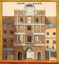
Newgate was one of the historic seven gates of the London Wall around the City of London and one of the six which date back to Roman times. From it, a Roman road led west to Silchester, Hampshire.[1]:31 Excavations in 1875, 1903 and 1909 revealed the Roman structure and showed that it consisted of a double roadway between two square flanking guardroom towers.[1]:272–3[2]
From the 12th century, at least, the gate was used as a prison for debtors and felons.[3] This, the notorious Newgate Prison, was later extended to the south on the site of the modern Central Criminal Court on Old Bailey. The gate was demolished in 1767.[3]
It was once thought that Newgate was "New" since it was built after the Roman period but archaeological evidence has shown that it was of Roman origin; it is therefore possible that the gate was so named when the Ludgate became less used due to the building of the fourth St Paul's Cathedral in the early medieval period.[4]
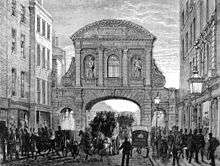
Newgate Street, today part of the A40 London to Fishguard route, is mostly located within the city wall, leading west from Cheapside to the site of the old gate, and then continuing onto Holborn Viaduct at the point where the Old Bailey thoroughfare joins to the south and Giltspur Street to the north. A notable discovery here was a Roman tile inscribed with a disgruntled comment that "Austalis has been going off on his own for 13 days".[1]:272
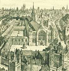
To the north of the street are the ruins of Christ Church Greyfriars on the site of a medieval Franciscan monastery. To the south is Paternoster Square leading towards St Paul's Cathedral.
See also
External links
References
- 1 2 3 Pevsner, Nikolaus (1973). London: Volume 1: The City of London: City of London v. 1. Yale University Press. ISBN 978-0300096248.
- ↑ Barker, Felix; Jackson, Peter (1974). London: 2000 Years of a City and its People. Weidenfeld Nicolson Illustrated. pp. 10–11. ISBN 0304292648.
- 1 2 Weinreb, Ben; Hibbert, Christopher (1983). The London Encyclopedia. Macmillan. p. 547. ISBN 1405049243.
- ↑ Halliday, Stephen (2007). Newgate: London's Prototype of Hell. The History Press. p. 3. ISBN 075093896X.
Coordinates: 51°30′53.09″N 0°6′1.22″W / 51.5147472°N 0.1003389°W
Gates and bars of the City of London | |||
|---|---|---|---|
 | Former gates of London Wall and City bars
Listed clockwise from the West
| ||