Newlay and Horsforth railway station
| Newlay and Horsforth | |
|---|---|
|
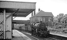
Eastbound freight train passing through Newlay station in 1964 | |
| Location | |
| Place | Newlay |
| Area | City of Leeds |
| Coordinates | 52°50′13″N 1°38′13″W / 52.837°N 1.637°WCoordinates: 52°50′13″N 1°38′13″W / 52.837°N 1.637°W |
| Grid reference | SE239368 |
| Operations | |
| Original company | Leeds and Bradford Railway |
| Pre-grouping | Midland Railway |
| Post-grouping | London, Midland and Scottish Railway |
| Platforms | 2 outside |
| History | |
| 1846 | Station opened as Newlay |
| 1889 | Station renamed as Newlay and Horsforth |
| 1961 | Station renamed as Newlay |
| 1965 | Station closed |
| Disused railway stations in the United Kingdom | |
|
Closed railway stations in Britain A B C D–F G H–J K–L M–O P–R S T–V W–Z | |
|
| |
Newlay and Horsforth railway station, until 1889 and from 1961 called Newlay station, was a station on the route of the former Leeds and Bradford Railway (now part of the Airedale Line and the Wharfedale Line), located on the right bank of the River Aire and on the left bank of the Aire and Calder Navigation between Horsforth in the north and Bramley in the south. It was accessed from Pollard Lane, which still crosses the railway on a bridge there, and served mainly the southern parts of Horsforth in West Yorkshire, England.
History
The station was opened by the Leeds and Bradford Railway in 1846. The latter was later absorbed by the Midland Railway), which became part of the London, Midland and Scottish Railway upon the 1923 Grouping. In 1905 the station was expanded with a second pair of tracks and a goods shed south of the line.[1] During World War I the station served in particular the National Ordnance Factory in Newlay.[2] Upon nationalisation, the station became part of the network of the Eastern Region of British Railways in 1948. It was closed on 22 March 1965 by the British Railways Board as a consequence of the Beeching Axe,[3] together with the stations Armley Canal Road, Kirkstall, Calverley & Rodley and Apperley Bridge on the same line.
Current situation

The station buildings have been demolished after closure, and the additional tracks built in 1905 have been lifted. Only the through tracks remain, which now carry services of the Airedale Line and the Wharfedale Line.[1]
| Preceding station | Historical railways | Following station | ||
|---|---|---|---|---|
| Calverley and Rodley | Midland Railway Leeds and Bradford Railway |
Kirkstall Forge | ||
References
- 1 2 Nigel Thompson (30 June 2014). "Newlay & Horsforth railway station (site), Yorkshire". geograph.org.uk.
- ↑ Mark Stevenson (2016). "National Ordnance Factory, Newlay, Leeds". geograph.org.uk.
- ↑ "Station Closures". Lost Railways West Yorkshire.
External links
| Wikimedia Commons has media related to Newlay and Horsforth railway station. |
- "1890s map of the surroundings of Newlay station". Retrieved 20 November 2016.
/Newlay.jpg)