Newtown Creek
| Newtown Creek | |
| Estuary | |
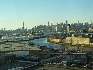 The Creek in Long Island City | |
| Country | United States |
|---|---|
| State | New York |
| Municipality | New York City |
| Tributaries | |
| - left | English Kills, Whale Creek |
| - right | Maspeth Creek, Dutch Kills |
| Source | Grand Avenue and 47th Street |
| - coordinates | 40°43′06″N 73°55′27″W / 40.718412°N 73.924127°W |
| Mouth | East River |
| - location | 2nd Street and 54th Avenue in Long Island City |
| - elevation | 0 ft (0 m) |
| - coordinates | 40°44′14″N 73°57′40″W / 40.73734°N 73.96112°WCoordinates: 40°44′14″N 73°57′40″W / 40.73734°N 73.96112°W |
| Length | 3.5 mi (6 km) |
| Discharge | |
| - average | 59.3 cu ft/s (2 m3/s) |
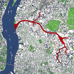 Newtown Creek and its tributaries | |
Newtown Creek, a 3.5-mile (6-kilometer) long tributary of the East River,[1] is an estuary that forms part of the border between the boroughs of Brooklyn and Queens, in New York City. Channelization made it one of the most heavily used bodies of water in the Port of New York and New Jersey and thus one of the most polluted industrial sites in the US,[2] containing years of discarded toxins, an estimated 30,000,000 US gallons (110,000,000 l; 25,000,000 imp gal) of spilled oil, including the Greenpoint oil spill, raw sewage from New York City’s sewer system,[2] and other accumulation from a total of 1,491 sites.[3]
Newtown Creek was proposed as a potential Superfund site in September 2009,[4] and received that designation on September 27, 2010.[5]
Course
_aerial_02_(9454373737).jpg)
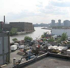
The creek begins near the intersection of 47th Street and Grand Avenue on the Brooklyn-Queens border at the intersection of the East Branch and English Kills.[6] It empties into the East River at 2nd Street and 54th Avenue in Long Island City, opposite Bellevue Hospital in Manhattan at 26th Street. Its waterfront, and that of its tributaries Dutch Kills, Whale Creek, Maspeth Creek and English Kills, are heavily industrialized.
Because the surrounded neighborhoods are completely sewerized, the creek has little natural inflow of natural freshwater.[1] Its outgoing flow of 14 billion US gallons (53,000,000 m3) per year consists of combined sewer overflow, urban runoff, raw domestic sewage, and industrial wastewater. The creek is largely stagnant, one cause being the 15-foot-thick (4.6 m) layer (in some places 25 feet (7.6 m)[3]) of polluted sludge that has congealed on the creek bed.[2]
The Montauk Branch of the Long Island Rail Road, used only for freight west of Jamaica, runs along the north bank.
History
The creek derives its name from New Town (Nieuwe Stad), which was the name for the Dutch and British settlement in what is now Elmhurst, Queens. Before the nineteenth century urbanization and industrialization of the surrounding neighborhoods, Newtown Creek was a longer and shallower tidal waterway, wide enough that it contained islands, including Mussel Island. It drained parts of what are now the neighborhoods of Bushwick, Williamsburg, and Greenpoint in Brooklyn; and Maspeth, Ridgewood, Sunnyside, and Long Island City in Queens.[7]
At the time of the American Revolution, British General Warren had his headquarters along the creek. The Sackett House was inherited by the wife of DeWitt Clinton, and Clinton stayed there during much of the planning of the Erie Canal project. Apples called Newtown Pippins originated on the estate of Gershom Moore there, and soon had a wide reputation, appearing on the "Select List" of apples issues by the Horticultural Society of London, and drawing the praise of Benjamin Franklin, Thomas Jefferson and Queen Victoria, who, after tasting the fruit, revoked the import tax on apples.[1]
Industrialization
Farmers used the creek to barge their goods to market early in the 19th century, but traffic on the creek increased dramatically when petroleum from Pennsylvania was shipped up the creek to facilities which had once distilled illuminating oil from coal. More refineries sprang up, including Robert Cheesebrough's for making petroleum jelly, marketed as Vaseline. There was only one refinery in Queens in 1860, but the demand for kerosene and other petroleum products, increased the number dramatically, all of which required large parcels of land for storage and processing, as well as pipelines for transporting the product. John D. Rockefeller decided that Standard Oil would be based in the Newtown Creek area, and soon began buying up the refineries of rivals, until by the 1880s the company was processing 3,000,000 US gallons (11,000,000 l; 2,500,000 imp gal) of crude oil weekly, employing two thousand people in their more than 100 stills.[8]
The pastoral land around the creek became "a vast interconnected complex of wharves, stills, tanks, and pipelines,"[9] to service not only the refineries, but also the facilities of related industries such as manufacturers of paint and varnish, and chemical companies which produced sulfuric acid. It is estimated that, in all, these industrial facilities produced 300,000 US gallons (1,100,000 l; 250,000 imp gal) of waste material each week, which was burnt off, or discarded into the air or the water of the creek. The waste included sludge acid, a tar-like substabce which was sold to companies that used it as an ingredient in superphosphate fertilizer. These companies, which built factories close to the source of their raw material, then dumped their waste into the environment, as did the chemical companies with the sulfur that was the waste from producing sulfuric acid.[9]
By now, Newtown Creek had become a major industrial waterway, with the city starting to dump raw sewage into it in 1866;[3] it was bounded along most of its length by retaining walls, the shipping channel maintained by dredging. Public protests over the degradation of the waterway and the surrounding area, and frequent newspaper exposés did little to ameliorate the problem, considering the economic benefit of the industries located along the creek and nearby. Queens was not yet a part of New York City meant that the city's Board of Health had no jurisdiction there, and the Brooklyn Board of Health sided with the polluters in court. Even a report from The New York Times in 1885 that Standard Oil was dumping sludge acid into the creek, covering the banks at low tide, made little difference. By the end of the 19th century, the Times was reporting that the creek was totally devoid of any lifeforms.[10]
The oil industry was centered in Greenpoint, Brooklyn. Across the creek, in Laurel Hill, or West Maspeth, Queens, chemical plants and copper smelting facilities did their part in fouling the waterway. At its peak, the Laurel Hill Chemical Works, owned by Phelps Dodge employed approximately 1,250 people, but the workforce declined when the company closed the smelter, and eventually the site was sold to the United States Postal Service in 1986. When the USPS discovered unacceptable levels of heavy metal waste from the smelting process, the U.S. Attorney's office forced Phelps Dodge to void the sale, take the property back, and to clean it up, which, as of 2016, has not been done.[11]
Before 1950, bulk-oil storage facilities near the corner of Manhattan Avenue and Huron Street were spilling petroleum in amounts that were eventually more than the Exxon Valdez oil spill. An underground explosion at the same corner added to the problem. BP, Chevron, and ExxonMobil have since removed half of the spill, about 12,000,000 US gallons (45,000,000 l; 10,000,000 imp gal), from the creek and surrounding area, selling the oil that was removed.
In 1973 the Peter van Iderstine plant which had been turning butcher's discards and at least one 10-ton elephant into fertilizer, animal feed, and glue since 1855 was charged with contaminating the creek with animal fats. The plant closed two years later but the smell of burning animals lingered.[3]
In 1978, a United States Coast Guard helicopter on a routine patrol discovered the Greenpoint oil spill, a discharge that lasted another 30 years that spilled three times the oil of the Exxon Valdez oil spill.[12]
In the early 2000s, during the construction boom, construction companies dumped concrete slurry into the creek. The city fined Empire Transit Mix in 2005 for ridding itself of its slurry through a secret pipe. Some off loads of other companies had pH levels equal to household ammonia.[3]

Clean up
The first steps towards cleaning up the toxic environment of Newtown Creek came in 1924, when the federal government entered the picture with an oil pollution law, albeit one which had been weakened by the industry as it made its way through Congress.[10]
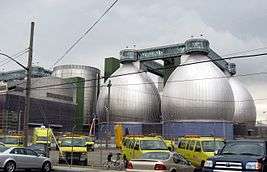
Then, in 1967, the city built the Newtown Creek Wastewater Treatment Plant,[13] which is now the largest sewage treatment facility operated by the New York City Department of Environmental Protection.[14] Located on the south bank near the creek's mouth in Greenpoint, the plant handles a large portion of the drainage from the East Side of Manhattan.Sewage from the Financial District, Greenwich Village, the Lower East Side, Midtown East and the East Side up to 71st Street flows through 180 miles (290 km) of sewer pipes intp interceptor pipes to the Thirteenth Street Pumping Station at 13th Street and Avenue D, from where it is sent under the East River to the plant. Normal influx is 120,000,000 US gallons (450,000,000 l; 100,000,000 imp gal) a day, which increases to 120,000,000 US gallons (450,000,000 l; 100,000,000 imp gal) during wet weather. When a significant overflow occurred during the New York City blackout of 1977 (828,000,000 US gallons (3.13×10⁹ l; 689,000,000 imp gal) of raw sewage spilled into the East River), the federal government ordered in 1995 that the city build back-up faciliities. Despite this, the Northeast blackout of 2003 produced 145,000,000 US gallons (550,000,000 l; 121,000,000 imp gal) of raw sewage spilled.[15]
In 1998, the city started its program to expand the facility. Construction was completed in 2014,[16] and the plant remained opened throughout the renovation process. The plant's unusual aesthetics, especially its 140-foot (42 meter) tall metallic "digester eggs" which are illuminated at night with blue lights, have made it a local landmark. In part to appease neighborhood residents who initially opposed the plant's expansion, the City of New York built a nature walk alongside Newtown Creek just outside the plant's perimeter in 2009.[17][18] Later the North Brooklyn Boat Club built a boatyard and education center with funds from the Exxon's settlement with the state to allow access to the creek.[19]
Even with the expansion of the plant, as of 2014, the city is still not in full compliance with the 1972 federal Clean Water Act, which mandates that secondary treatment should remove 85% of pollutants from incoming sewage, or with New York State's 1992 order for the city to prevent overflows by 2013.[20] Overflows from the Newtown Creek plant on the order of 100,000,000 US gallons (380,000,000 l; 83,000,000 imp gal) occur on the average of once a week.[16] When that occurs
When sewage loads exceed the capacity of the Newtown Creek Sewage Treatment Facility trash, pesticides, petroleum products, PCBs, mercury, cadmium, lead, pathogenic microorganisms, and nutrients which reduce the dissolved oxygen content of the water are dumped into Newtown Creek. This dumping is referred to as a combined sewer overflow or CSO. CSOs can be triggered by as little as a tenth of an inch of rain.Essentially anything that gets washed into the gutters from the street, anything that households and businesses flush down the toilet or dump down the drain, has a fair chance of being expelled directly into Newtown Creek or New York Harbor untreated. In New York City a CSO event occurs once a week on average, discharging approximately 500 million gallons of raw sewage directly into New York Harbor. CSOs are the single largest impairment to the quality of New York City's waters.[21]
The city requested a postponment of the 2013 deadline in consideration of its plan to build a fully compliant Newtown Creek plant by 2022.[20]
In 2007, residents of Greenpoint, Brooklyn and the New York State Attorney General's Office filed lawsuits regarding the Greenpoint oil spill. On September 27, 2010, the federal Environmental Protection Agency designated Newtown Creek as a Superfund site, preparing the way for evaluation and environmental remediation of the stream. Environment advocacy groups supported the decision.[22]
Water quality
Although the wastewater treatment plant has been expanded, even small amounts of rainfall can overwhelm the system and lead to the dumping of raw sewage and street runoff directly into the creek from 23 different locations. These combined sewer overflows contribute to ongoing pollution of the creek. The margin between rainfall and sewage overflow only thins with the city's further development. In addition, it was reported in December 2013 that in addition to oil and human waste, EPA crews were expected to find toxic substances such as arsenic, cesium-137, and polychlorinated biphenyls.[3]
Bridges
Newtown Creek is crossed by the Pulaski Bridge (replacing the Vernon Avenue Bridge in the 1950s), the J. J. Byrne Memorial Bridge or Greenpoint Avenue Bridge, and the Kosciuszko Bridge, which carries the Brooklyn Queens Expressway. Some of the bridges that cross it and its tributaries are named for the street that they carry, such as Grand Street Bridge and Metropolitan Avenue Bridge.
See also
- Arthur Kill (Staten Island)
- Geography of New York-New Jersey Harbor Estuary
- Gowanus Canal
- Hunters Point, Queens
References
Notes
- 1 2 3 Eldredge & Horenstein (2014), p.150
- 1 2 3 Staff (December 12, 2008). "Newtown Creek Clean-Up Efforts". The City Concealed. Thirteen (WNET.org). Retrieved 2009-06-29.
- 1 2 3 4 5 6 Smith, Peter Andrey (December 16, 2013). "Liquid Cow and Black Mayo". New York. p. 20.
- ↑ "Newtown Creek Superfund Site". U.S. Environmental Protection Agency. Retrieved 2010-09-29.
- ↑ Navarro, Mireya (September 27, 2010). "Newtown Creek Is Declared a Superfund Site". The New York Times. Retrieved 2010-09-27.
- ↑ "Newtown Creek Alliance". Newtown Creek Alliance. Archived from the original on January 24, 2010. Retrieved 2010-02-21.
- ↑ Kadinsky, Sergey (2016) Hidden Waters of New York City Countryman Press. Pp. 174-185 ISBN 978-1-58157-355-8
- ↑ Eldredge & Horenstein (2014), pp.151-53
- 1 2 Eldredge & Horenstein (2014), p.153
- 1 2 Eldredge & Horenstein (2014), p.154
- ↑ Eldredge & Horenstein (2014), pp.155-56
- ↑ Walker, Dalton (July 19, 2007). "Exxon Mobil Cleanup Effort Continues on Brooklyn Spill". The New York Times. Retrieved 2010-02-21.
- ↑ Jones, Raymond McCrea (February 9, 2011). "Transforming the Sludge at Newtown Creek (slideshow)". The New York Times. Retrieved October 14, 2013.
- ↑ "Newtown Creek Wastewater Treatment Plant". New York City Department of Environmental Protection (NYCDEP). Retrieved October 13, 2013.
- ↑ Eldredge & Horenstein (2014), pp.156-157
- 1 2 Eldredge & Horenstein (2014), p.157
- ↑ "The Newtown Creek Nature Walk (flyer)" (PDF). New York City Department of Environmental Protection. Retrieved 14 October 2013.
- ↑ Korman, Benjamin (September 1, 2011). "Nature Does Not Knock". 7STOPS. Retrieved 2011-09-18.
- ↑ Watson, Ryan (October 1, 2012) "A Dream On Its Way to Reality: The Greenpoint Boathouse & Environmental Education Center" Greenpoint Waterfront Association for Parks and Planning (GWAPP). Retrieved: July 28, 2013
- 1 2 Eldredge & Horenstein (2014), p.158
- ↑ Staff (ndg) Newtown Creek Sewage Treatment Facility HabitatMap
- ↑ Associated Press (September 28, 2009). "US adds industrialized NYC creek to Superfund list". Business Week. Retrieved 2010-09-28.
Bibliography
- Eldredge, Niles & Horenstein, Sidney (2014), Concrete Jungle: New York City and Our Last Best Hope for a Sustainable Future, Berkeley, California: University of California Press, ISBN 978-0-520-27015-2
Further reading
- Video: exploring the wasted banks of Newtown Creek
- N.Y. Times: Between Queens and Brooklyn, an Oil Spill’s Legacy
- PBS: P.O.V.'s Borders: The Invisible Creek
- Forgotten New York -- A boat ride down Newtown Creek -- photos and history
External links
| Wikimedia Commons has media related to Newtown Creek. |
- Newtown Creek Alliance, community-based organization
- Riverkeeper
- Newtown Creek Advisory Group -- updated info about EPA assessments and cleanup
- Greenpoint v. Exxon
- Greenpoint Waterfront Association for Parks and Planning