Niagara Falls, New York
| Niagara Falls, New York | |
|---|---|
| City | |
| City of Niagara Falls | |
|
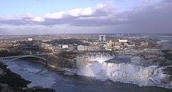
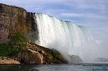
The city of Niagara Falls. In the foreground are the waterfalls known as the American Falls and Bridal Veil Falls, respectively, from left to right. | |
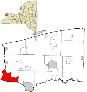 Location in Niagara County and the state of New York. | |
| Coordinates: 43°6′N 79°1′W / 43.100°N 79.017°WCoordinates: 43°6′N 79°1′W / 43.100°N 79.017°W | |
| Country | United States |
| State | New York |
| County | Niagara |
| Government | |
| • Type | Strong mayor-council |
| • Mayor | Paul A. Dyster (D) |
| • City Administrator | Nicholas A. Melson |
| • City Council |
Members' List
|
| Area | |
| • City | 16.8 sq mi (43.5 km2) |
| • Land | 14.1 sq mi (36.4 km2) |
| • Water | 2.8 sq mi (7.1 km2) 16.37% |
| • Urban | 366.7 sq mi (949.7 km2) |
| Elevation | 614 ft (187 m) |
| Population (2013)[1] | |
| • City | 49,468 |
| • Density | 3,955.7/sq mi (1,527.3/km2) |
| • Urban | 935,906 (US: 46th) |
| • Urban density | 2,663.5/sq mi (1,028.37/km2) |
| • Metro | 1,134,155 (US: 50th) |
| Time zone | Eastern (EST) (UTC-5) |
| • Summer (DST) | EDT (UTC-4) |
| ZIP codes | 14301-14305 |
| Area code(s) | 716 |
| FIPS code | 36-51055 |
| GNIS feature ID | 0970406 |
| Demonym | Niagarian, Niagara Fallsite |
| Website | Official website |
Niagara Falls (/naɪˈæɡrə/ ny-AG-ra) is a city in Niagara County, New York, United States. As of the 2010 census, the city had a total population of 50,193, down from the 55,593 recorded in the 2000 census. It is adjacent to the Niagara River, across from the city of Niagara Falls, Ontario, and named after the famed Niagara Falls which they share. The city is within the Buffalo–Niagara Falls Metropolitan Statistical Area as well as the Western New York region.
While the city was formerly occupied by Native Americans, Europeans who migrated to the Niagara Falls in the mid-17th century began to open businesses and develop infrastructure. Later in the 18th and 19th centuries, scientists and businessmen began harnessing the power of the Niagara River for electricity and the city began to attract manufacturers and other businesses that were drawn by the promise of inexpensive hydroelectric power. After the 1960s, however, the city and region witnessed an economic decline consistent with the rest of the Rust Belt as industries left the city and affluent families relocated to nearby suburbs. Globalization has played a large role in the decline of manufacturing in the city.
Despite the decline in heavy industry, Niagara Falls State Park and the downtown area closest to the falls continue to thrive as a result of tourism. The population, however, has continued to decline from a peak of 102,394 in the 1960s due to the loss of manufacturing jobs in the area.
History
Before Europeans entered the area, it was dominated by the Neutral Nation of Native Americans. European migration into the area began in the 17th century. The first recorded European to visit the area was Frenchman Robert de la Salle, accompanied by Belgian priest Louis Hennepin, who was the first known European to see the falls. The influx of newcomers may have been a catalyst for already hostile native tribes to turn to open warfare in competition for the fur trade.
The City of Niagara Falls was incorporated on March 17, 1892, from the villages of Manchester and Suspension Bridge, which were parts of the Town of Niagara. New York State Governor Roswell P. Flower signed a bill forming the city. Thomas Vincent Welch who was a member of the charter committee and then a New York state assemblyman, but more importantly a second-generation Irishman, was responsible for asking Governor Flower to sign the bill on St. Patrick's Day. George W. Wright was elected the first mayor of Niagara Falls.[2]
By the end of the 19th century, the city was a heavy industrial area, due in part to the power potential offered by the Niagara River. Tourism was considered a secondary niche, while industry was the main producer of jobs and the economic backbone.

In 1927, the city annexed the village of La Salle from the Town of Niagara. The village was named for the French explorer Robert de La Salle, who built his ship, the Griffon, on the shores of the river five miles east. Robert de la Salle.
Ever since the early 20th century, the center of the tourist district was Falls Street. Much of Falls Street was razed in an ill-conceived urban renewal project. Ultimately, a convention center and casino were built to generate more tourism.
Industry and tourism grew steadily throughout the first half of the 20th century due to a high demand for industrial products and the increased mobility of people to travel. Paper, rubber, plastics, petrochemicals, carbon insulators and abrasives were among the city's major industries. This prosperity would end by the late 1960s as aging industrial plants moved to less expensive locations.
In 1956, the Schoellkopf Power Plant on the lower river just downstream of the American Falls was critically damaged due to a massive collapse of the Niagara Gorge wall above it. This prompted the planning and construction of one of the largest hydroelectric plants to be built in North America at that time, causing a large influx of workers and families to move to the area. New York City urban planner Robert Moses built the new power plant in nearby Lewiston, New York. Much of the power went downstate to fuel growing demands for New York City.
The contaminated Love Canal neighborhood gained national media attention in 1978 when toxins from a chemical waste landfill within the site forced United States President Jimmy Carter to declare the area a national disaster, with hundreds of residents relocating.[3]
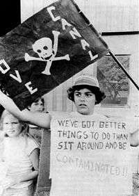
After the Love Canal disaster, the city witnessed a reversal of fortunes, as labor in Niagara Falls was cheaper to outsource to other countries. Several factories closed, the population dropped by half, and workers fled the city in search of jobs elsewhere. Much like the nearby city of Buffalo, the city's economy plummeted downward when a failed urban renewal project took place resulting in the destruction of Falls Street and the tourist district.
In 1995, the city was the defendant in NAACP v. City of Niagara Falls. In the suit the NAACP said the city was violating Section 2 of the Voting Rights Act of 1965. At the time, Niagara Falls' government consisted of a mayor, who acted as chief executive, and seven city council members elected at-large. The NAACP also said the city had not given enough representation to African Americans living in the city, which at that time comprised 15.6% of the city's population. The court ruled in favor of the city, which kept its system of government.
In 2001, the leadership of Laborers Local 91 was found guilty of extortion, racketeering and other crimes following an exposé by Mike Hudson of the Niagara Falls Reporter. Union boss Michael "Butch" Quarcini died before trial began, while the rest of the union leadership was sentenced to prison.

In early 2010, former Niagara Falls Mayor Vincent Anello was indicted on federal charges of corruption, alleging that the mayor accepted $40,000 in loans from a businessman who was later awarded a no-bid lease on city property. The charges were dropped as part of a plea deal after Anello plead guilty to unrelated charges of pension fraud, regarding a pension from the International Brotherhood of Electrical Workers, of which he is a member. He was ultimately sentenced to 10 to 16 months in prison.[4]
The decline of the city was given national exposure by Bloomberg Businessweek in 2010.[5]
On November 30, 2010, the New York State Attorney General entered into an agreement with the city and its police department to create new policies to govern police practices in response to claims of excessive force and police misconduct. The city will create policies and procedures to prevent and respond to allegations of excessive force, and to ensure that police are properly trained and complaints are properly investigated. Prior claims filed by residents will be evaluated by an independent panel.[6]
The city has a number of properties on the National Register of Historic Places.[7] It also has three national historic districts, including Chilton Avenue-Orchard Parkway Historic District, Deveaux School Historic District and the Park Place Historic District.
Geography
Niagara Falls is located at the international boundary between the United States of America and Canada. The city is within the Buffalo–Niagara Falls metropolitan area and is approximately 15 miles (24 km) from Buffalo, New York.
According to the United States Census Bureau, the city has a total area of 16.8 square miles (44 km2), of that, 14.1 square miles (37 km2) of it is land and 2.8 square miles (7.3 km2) of it (16.37%) is water.[8] The city is built along the Niagara Falls and the Niagara Gorge, which is located next to the Niagara River.
Climate
Niagara Falls experiences cold, snowy winters and hot, humid summers. Precipitation is moderate and consistent in all seasons, falling equally or more as snow during the winter. The city has snowier than average winters compared to most cities in the USA, however less than many other cities in Upstate New York including nearby Buffalo and Rochester. Thaw cycles with temperatures above 0 °C (32 °F) are a common occurrence.[9] The hottest and coldest temperatures recorded in the past decade were 97 °F (36 °C) in 2005 and -13 °F (-25 °C) in 2003, respectively.[9] 38% of warm season precipitation falls in the form of a thunderstorm.[10]
| Climate data for (Niagara Falls International Airport), New York 1981–2010, extremes 1951–present | |||||||||||||
|---|---|---|---|---|---|---|---|---|---|---|---|---|---|
| Month | Jan | Feb | Mar | Apr | May | Jun | Jul | Aug | Sep | Oct | Nov | Dec | Year |
| Record high °F (°C) | 65 (18) |
61 (16) |
81 (27) |
85 (29) |
91 (33) |
95 (35) |
97 (36) |
95 (35) |
96 (36) |
85 (29) |
79 (26) |
66 (19) |
97 (36) |
| Average high °F (°C) | 32.1 (0.1) |
34.1 (1.2) |
42.5 (5.8) |
55.7 (13.2) |
67.7 (19.8) |
76.5 (24.7) |
81.1 (27.3) |
79.4 (26.3) |
72.1 (22.3) |
60.2 (15.7) |
48.2 (9) |
36.8 (2.7) |
57.3 (14.1) |
| Daily mean °F (°C) | 23.8 (−4.6) |
25.4 (−3.7) |
33.2 (0.7) |
45.2 (7.3) |
56.4 (13.6) |
66.1 (18.9) |
70.9 (21.6) |
69.1 (20.6) |
61.6 (16.4) |
50.2 (10.1) |
39.8 (4.3) |
29.3 (−1.5) |
47.7 (8.7) |
| Average low °F (°C) | 15.4 (−9.2) |
16.7 (−8.5) |
23.9 (−4.5) |
34.6 (1.4) |
45.2 (7.3) |
55.6 (13.1) |
60.8 (16) |
58.9 (14.9) |
51.0 (10.6) |
40.2 (4.6) |
31.3 (−0.4) |
21.8 (−5.7) |
38.1 (3.4) |
| Record low °F (°C) | −16 (−27) |
−13 (−25) |
−8 (−22) |
12 (−11) |
28 (−2) |
37 (3) |
46 (8) |
45 (7) |
30 (−1) |
23 (−5) |
−2 (−19) |
−4 (−20) |
−16 (−27) |
| Average precipitation inches (mm) | 2.56 (65) |
2.19 (55.6) |
2.41 (61.2) |
2.69 (68.3) |
3.07 (78) |
2.93 (74.4) |
3.24 (82.3) |
3.02 (76.7) |
3.35 (85.1) |
2.88 (73.2) |
3.40 (86.4) |
3.23 (82) |
34.97 (888.2) |
| Average snowfall inches (cm) | 23.6 (59.9) |
15.2 (38.6) |
12.9 (32.8) |
2.5 (6.4) |
0.0 (0) |
0.0 (0) |
0.0 (0) |
0.0 (0) |
0.0 (0) |
0.2 (0.5) |
3.5 (8.9) |
18.2 (46.2) |
76.1 (193.3) |
| Average precipitation days (≥ 0.01 in) | 19.2 | 14.4 | 13.7 | 12.8 | 12.8 | 11.2 | 10.8 | 9.8 | 10.7 | 12.2 | 14.0 | 17.1 | 158.7 |
| Average snowy days (≥ 0.1 in) | 15.0 | 11.7 | 7.7 | 2.4 | 0.0 | 0.0 | 0.0 | 0.0 | 0.0 | 0.2 | 3.9 | 11.9 | 52.8 |
| Source: NOAA[9][11] | |||||||||||||
Neighborhoods
Niagara Falls is home to nine neighborhoods:
- Little Italy - runs along Pine Avenue from Portage to Hyde Park Boulevard
- North End - runs along Highland Avenue in the north end of the city
- Deveaux, Niagara Falls - Located in the northwestern corner (west of the North End) along the Niagara River is residential area built in the 1920s to 1940s. Named for Judge Samuel DeVeaux who left his estate to be established as the Deveaux College for Orphans and Destitute Children in 1853 (closed 1971), now the site of DeVeaux Woods State Park[12] and DeVeaux School Historical District.
- LaSalle, Niagara Falls - Area bounded by 80th Street, Niagara Falls Boulevard, Cayuga Drive and Lasalle Expressway was built up in the 1940s to 1960s.[13]
- Downtown, Niagara Falls - Area around the Falls and home to hotels including Seneca Niagara Resort Casino, Niagara Falls State Park, Niagara Falls Culinary Institute (formerly Rainbow Outlet Mall)
- Niagara Street, Niagara Falls - residential area located east of Downtown along Niagara Street
- East Side, Niagara Falls
- Buffalo Avenue, Niagara Falls - runs along the south end along the Niagara River; surrounded by a number of industrial sites in what is referred to as Chemical Row
- Hyde Park, Niagara Falls - Located near the namesake Hyde Park next to Little Italy as well as home to Hyde Park Municipal Golf Course.[14]
Demographics
| Historical population | |||
|---|---|---|---|
| Census | Pop. | %± | |
| 1870 | 3,006 | — | |
| 1880 | 3,320 | 10.4% | |
| 1890 | 5,502 | 65.7% | |
| 1900 | 19,457 | 253.6% | |
| 1910 | 30,445 | 56.5% | |
| 1920 | 50,760 | 66.7% | |
| 1930 | 74,460 | 46.7% | |
| 1940 | 78,020 | 4.8% | |
| 1950 | 90,872 | 16.5% | |
| 1960 | 102,394 | 12.7% | |
| 1970 | 85,615 | −16.4% | |
| 1980 | 71,384 | −16.6% | |
| 1990 | 61,840 | −13.4% | |
| 2000 | 55,593 | −10.1% | |
| 2010 | 50,193 | −9.7% | |
| Est. 2015 | 48,916 | [15] | −2.5% |
| U.S. Decennial Census[16] 2013 Estimate[17] | |||
As of the census of 2010, there were 50,193 people, 22,603 households, and 12,495 families residing in the city. The population density was 2,987.7 people per square mile (1,153.5 per square km). There were 26,220 housing units at an average density of 1,560.7 per square mile (622.6/km²). The racial makeup of the city was 70.5% White, 21.6% African American, 1.9% Native American, 1.2% Asian, 0% Pacific Islander, 0.8% from other races, and 3.9% from two or more races. Hispanic or Latino of any race were 3.0% of the population.
There were 22,603 households out of which 23.9% had children under the age of 18 living with them, 29.8% were married couples living together, 19.7% had a female householder with no husband present, and 44.7% were non-families. 38.1% of all households were made up of individuals and 13.7% had someone living alone who was 65 years of age or older. The average household size was 2.20 and the average family size was 4.02.

In the city the population was spread out with 22% under the age of 18, 10.1% from 18 to 24, 24.2% from 25 to 44, 28.2% from 45 to 64, and 15.5% who were 65 years of age or older. The median age was 39 years. For every 100 females there were 91.2 males. For every 100 females age 18 and over, there were 94.4 males.
The median income for a household in the city was $26,800, and the median income for a family was $34,377. Males had a median income of $31,672 versus $22,124 for females. 23% of the population was below the poverty line.
Niagara Falls has a number of places of worship, including the Salvation Army, First Assembly of God Church, First Unitarian Universalist Church of Niagara, St. Peter's Episcopal Church, First Presbyterian Church, St. Theresa Roman Catholic Church in Devaux, Reform Jewish Temple Beth El and the Conservative Jewish Temple Beth Israel.
Although statistically lower in crime than cities in Western New York such as Buffalo and Rochester, Niagara Falls still suffers from a higher than average crime rate.[18] In the wake of recent gun violence, volunteer groups such as the SNUG movement have been mobilized to stop violence in the city and promote positive community involvement in the troubled areas of the city.[19]
Economy
Currently, Niagara Falls' main industry is tourism. The city and falls are currently visited by almost ten million people each year, with the waterfall considered one of the United States' top ten tourist destinations.[20] However, the city struggles to compete with Niagara Falls, Ontario, which has a much more vibrant tourism industry and stronger economy.[21]
The city's economy was originally based around the power generated by Niagara Falls' rushing water. This cheap and abundant source of power was the driving force behind the rapid rise of area industry. Around the turn of the 20th century, thousands of immigrants from predominantly European nations such as Italy, Germany and Poland came to the area to work the chemical, steel, and manufacturing plants owned by present-day companies such as the Occidental Petroleum company.
The city, which once boasted slightly over 100,000 people at its peak, has seen its population decline by some 50 percent, as industries shut down and people left for the employment opportunities of the South and West. The unemployment rate in the City of Niagara Falls was approximately 10 percent as of October 2010.[22] About 60 percent of residents in Niagara Falls receive public assistance such as food stamps, welfare, unemployment insurance and Medicaid.[23]
Local and state government officials have vowed to embrace the physical and cultural advantages that the Niagara region naturally possesses, such as the Niagara Gorge, wine trails, historical landmarks, Little Italy, or Niagara Falls itself. These marketing efforts have attempted to move focus away from the city's industrial past to embrace a tourism-based economy. In late 2001, the State of New York established the USA Niagara Development Corporation, a subsidiary to the State's economic development agency, to focus specifically on facilitating development in the downtown area. However, the organization has been criticized for making little progress and doing little to improve the city's economy.[24][25]
Tourism
The city is home to the Niagara Falls State Park. The park has several attractions, including Cave of the Winds behind the Bridal Veil Falls, Maid of the Mist, a popular boat tour which operates at the foot of the Rainbow Bridge, Prospect Point and its observation tower, Niagara Discovery Center, and the Aquarium of Niagara.
Several other attractions also near the river, including Whirlpool State Park, De Veaux Woods State Park, Earl W. Brydges Artpark State Park in nearby Lewiston, New York, and Fort Niagara State Park in Youngstown, New York.
Attractions in the downtown include the Seneca Niagara Casino & Hotel. Pine Avenue was historically home to a large Italian American population.
Sports
Former sports teams based in Niagara Falls include the Class-A Niagara Falls Sox Minor League Baseball, the Class-A Niagara Falls Rapids and the Niagara Power a New York Collegiate Baseball League team was located within Niagara Falls.
Government
The City of Niagara Falls functions under a strong mayor-council form of government. The government consists of a mayor, a professional city administrator, and a city council. As of 2011, Paul Dyster is the first mayor of the city to be re-elected since 1987.
The city council serves four-year, staggered terms, except in the case of a special election. It is headed by a chairperson, who votes in all items for council action.
On a state level, Niagara Falls is part of the 138th Assembly District of New York State, currently represented by Republican John Ceretto. Niagara Falls is also part of the 60th Senate District of New York State, represented by Mark Grisanti.
On a national level, the city is part of New York's 26th congressional district and is represented by Congressman Brian Higgins. In the United States Senate, the city and the state are represented by senators Charles Schumer and Kirsten Gillibrand.
In 2015, the city's recycling mascot, Totes McGoats, received national attention.[26][27]
Totes McGoats
| Totes McGoats | |
|---|---|
| First appearance | October 14, 2015 |
| Information | |
| Species | Goat |
| Gender | Male |
Totes McGoats is the environmental mascot of Niagara Falls, New York. Portrayed as a goat, it rose to national prominence in 2015 as the mascot of the city's recycling program.[28][29][30][31]
Lackluster recycling statistics in the city prompted the city to find a way to improve on its four percent recycling rate, at the time the worst in Western New York, according to the Investigative Post.[32] In response, the mascot was invented by Brook D'Angelo, coordinator of the city's Solid Waste Education and Enforcement Team, as a way to promote recycling.[33]
While the mascot has since evolved into an internet meme, it has been compared with other civic promotional campaigns, including Smokey Bear and Woodsy Owl.[34]
Education
Residents are zoned to the Niagara Falls City School District. Niagara University and Niagara County Community College are the two colleges in Niagara County.
Media
Since Niagara Falls is within the Buffalo–Niagara Falls metropolitan area, the city's media is predominantly served by the city of Buffalo.
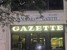
The city has one local newspaper, the Niagara Gazette, which is published daily except Tuesday. The Buffalo News is the closest major newspaper in the area and once had a Niagara County, NY bureau that extensively covered Niagara Falls and its surrounding communities. The city also is the home to a weekly tabloid known as the Niagara Falls Reporter.
Three radio stations are licensed to the city of Niagara Falls, including WHLD AM 1270, WJJL AM 1440, and WTOR AM 770.
Infrastructure
Niagara Falls is primarily served by the Buffalo Niagara International Airport for regional and domestic flights within the United States. The recently expanded Niagara Falls International Airport serves the city, and many cross border travellers with flights to Myrtle Beach, Fort Lauderdale, Orlando and Punta Gorda. Toronto's Pearson International Airport on the Canadian side is the closest airport to offer long-haul international flights for the Niagara region.
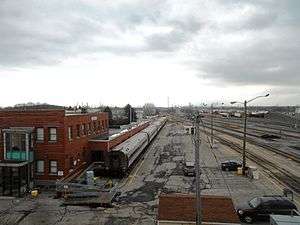
The city is served by Amtrak's Maple Leaf and Empire train services, with regular stops at its station at 27th Street and Lockport Road.
Niagara Frontier Transportation Authority is the public transit provider in the Buffalo metro area, with hubs at the Portage Road and Niagara Falls transportation centers.
Six New York State highways, one three-digit Interstate Highway, one expressway, one U.S. Highway, and one parkways pass through the city of Niagara Falls. New York State Route 31, New York State Route 104, and New York State Route 182 are east-west state roadways within the city, while New York State Route 61, New York State Route 265, and New York State Route 384 are north-south state roadways within the city. The LaSalle Expressway is an east-west highway which terminates near the eastern edge of Niagara Falls and begins in the nearby town of Wheatfield, New York. The Robert Moses State Parkway is a north-south parkway that runs through the city along the northern edge of the Niagara River and terminates in Youngstown, New York.
Interstate 190, also referred to as the Niagara Expressway, is a north-south highway and a spur of Interstate 90 which borders the eastern end of the city. The highway enters the city from the town of Niagara and exits at the North Grand Island Bridge. U.S. Route 62, known as Niagara Falls Boulevard, Walnut Avenue, and Ferry Avenue, is signed as a north-south highway. U.S. Route 62 has an east-west orientation, and is partially split between two one-way streets within Niagara Falls. Walnut Avenue carries U.S. Route 62 west to its northern terminus at NY 104, and Ferry Avenue carries U.S. Route 62 east from downtown Niagara Falls. U.S. Route 62 Business, locally known as Pine Avenue, is an east-west route which parallels U.S. Route 62 to the south. Its western terminus is at NY 104, and its eastern terminus is at U.S. Route 62.
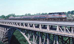
Two international bridges connect the city to Niagara Falls, Ontario. The Rainbow Bridge connects the two cities with passenger and pedestrian traffic and overlooks the Niagara Falls, while the Whirlpool Rapids Bridge, which formerly carried the Canadian National Railway, now serves local traffic and Amtrak's Maple Leaf service.
Notable people
See also
References
- ↑ "Population Estimates". United States Census Bureau. Retrieved 2014-06-15.
- ↑ "Niagara Falls New York Township History - The City of Niagara Falls, New York, USA". Niagarafallsinfo.com. Retrieved 2012-03-22.
- ↑ "Love Canal Collection". University of Buffalo Libraries. Retrieved 2007-02-03.
- ↑ Pfeiffer, Rick (September 2, 2010). "Prison for former Falls mayor Vince Anello". Niagara Gazette. Retrieved October 29, 2015.
- ↑ "The Fall of Niagara Falls". Bloomberg Business. December 2, 2010. Retrieved March 30, 2015.
- ↑ New York State Office of the Attorney General (November 30, 2010). "Attorney General Cuomo Reaches Agreement With The City Of Niagara Falls To Reform Its Police Practices". Ag.ny.gov. Retrieved March 30, 2015.
- ↑ National Park Service (2008-04-15). "National Register Information System". National Register of Historic Places. National Park Service.
- ↑ United States Census Bureau (2010). "American FactFinder - Geographic Identifiers, Niagara Falls city, New York". Factfinder.census.gov. Retrieved March 30, 2015.
- 1 2 3 "NOWData - NOAA Online Weather Data". National Oceanic and Atmospheric Administration. Retrieved September 27, 2015.
- ↑ "Weather Spark Niagara". Retrieved December 9, 2013.
- ↑ "NY Niagara Falls INTL AP". National Oceanic and Atmospheric Administration. Retrieved September 27, 2015.
- ↑ ": Niagara County Historical Society's Bicentennial Moments - DeVeaux School". Niagara2008.com. Retrieved 2016-11-24.
- ↑ "La Salle 14304 Niagara Falls, NY Neighborhood Profile". Neighborhoodscout.com. Retrieved 2016-11-24.
- ↑
- ↑ "Annual Estimates of the Resident Population for Incorporated Places: April 1, 2010 to July 1, 2015". Retrieved July 2, 2016.
- ↑ United States Census Bureau. "Census of Population and Housing". Retrieved June 15, 2014.
- ↑ "Annual Estimates of the Resident Population: April 1, 2010 to July 1, 2013". Retrieved June 15, 2014.
- ↑ "Niagara Falls crime rates and statistics". NeighborhoodScout. Retrieved 2012-03-22.
- ↑ Nalina Shapiro Posted by: Kellie Mazur (2011-04-17). "Residents on mission to stop violence". WIVB.com. Retrieved 2012-03-22.
- ↑ "Niagara Falls ranked in top 10 U.S. destinations by Forbes". Niagara Frontier Publications. Retrieved 2012-11-23.
- ↑ Brady, Jonann (2008-09-16). "Niagara Falls: A Tale of Two Cities - ABC News". Abcnews.go.com. Retrieved 2012-03-22.
- ↑ "Niagara Falls, New York (NY) profile: population, maps, real estate, averages, homes, statistics, relocation, travel, jobs, hospitals, schools, crime, moving, houses, news, sex offenders". City-data.com. Retrieved 2012-03-22.
- ↑ "Record number in government anti-poverty programs". Richard Wolf. 2010-08-30. Retrieved 2012-11-23.
- ↑ Anonymous (2009-08-03). "NIAGARA FALLS: Tourism talk turns heated " Local News". Niagara Gazette. Retrieved 2012-03-22.
- ↑ "USA NIAGARA: The 'Times Square' promise " Local News". Niagara Gazette. 2009-02-01. Retrieved 2012-03-22.
- ↑ "'Totes McGoats' is a Recycling Superstar". NBC News. Retrieved 2015-10-18.
- ↑ Basu, Tanya. "This Terrifying Recycling Mascot is Named Totes McGoats". TIME.com. Retrieved 2015-10-18.
- ↑ "'Totes McGoats' is a Recycling Superstar - NBC News". NBC News. Retrieved 2015-10-17.
- ↑ Basu, Tanya. "This Terrifying Recycling Mascot is Named Totes McGoats". TIME.com. Retrieved 2015-10-17.
- ↑ "This Mascot's Name Is Totes McGoats, And He's Here To Terrify Children Into Recycling". MTV News. Retrieved 2015-10-17.
- ↑ "3 creepy landmarks around Niagara Falls". WFTS. Retrieved 2015-10-17.
- ↑ Telvock, Dan (May 27, 2014). "Subpar recycling effort in suburbs". Investigative Post. Retrieved 2015-10-17.
- ↑ Becker, Maki (October 17, 2015). "How Totes McGoats came to Internet stardom - The Buffalo News". The Buffalo News. Retrieved 2015-10-17.
- ↑ Guff, Samantha (October 14, 2015). "'Totes McGoats' is the New Face of Niagara Falls Recycling". The Huffington Post. Retrieved 2015-10-17.
Further reading
- Mah, Alice. Industrial Ruination, Community, and Place: Landscapes and Legacies of Urban Decline (University of Toronto Press; 2012) 240 pages; comparative study of urban and industrial decline in Niagara Falls (Canada and the United States), Newcastle upon Tyne, Britain, and Ivanovo, Russia.
External links
| Wikisource has the text of the 1911 Encyclopædia Britannica article Niagara Falls, New York. |
 Media related to Niagara Falls, New York at Wikimedia Commons
 Niagara Falls, New York travel guide from Wikivoyage
- Official website
- Niagara Falls Handbill Collection, 1838-1886 RG 551 Brock University Library Digital Repository
- Niagara Falls Photo Album, 1906 RG 556 Brock University Library Digital Repository
| Principal city |  | |
|---|---|---|
| Other major cities | ||
| Counties | ||
Municipalities and communities of Niagara County, New York, United States | ||
|---|---|---|
| Cities | 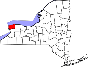 | |
| Towns | ||
| Villages | ||
| CDPs | ||
| Other hamlets |
| |
| Indian reservations | ||
| Footnotes | ‡This populated place also has portions in an adjacent county or counties | |