Niangua River
| Niangua River | |
| Country | United States |
|---|---|
| State | Missouri |
| Tributaries | |
| - left | Little Niangua River |
| Source confluence | |
| - location | Webster County, Missouri |
| - elevation | 1,136 ft (346 m) |
| - coordinates | 37°26′46″N 92°55′11″W / 37.44611°N 92.91972°W |
| Mouth | Lake of the Ozarks |
| - location | Camden County, Missouri |
| - elevation | 663 ft (202 m) |
| - coordinates | 37°57′39″N 92°48′22″W / 37.96083°N 92.80611°WCoordinates: 37°57′39″N 92°48′22″W / 37.96083°N 92.80611°W [1] |
| Length | 125 mi (201 km) |
| Basin | 1,040 sq mi (2,694 km2) |
| Discharge | for USGS 06923950 at Tunnel Dam near Macks Creek, MO[2] |
| - average | 450 cu ft/s (13 m3/s) |
| - max | 27,700 cu ft/s (784 m3/s) |
| - min | 0 cu ft/s (0 m3/s) |
| Watersheds | Niangua-Osage-Missouri-Mississippi |
| Reservoirs | Lake Niangua, Lake of the Ozarks |
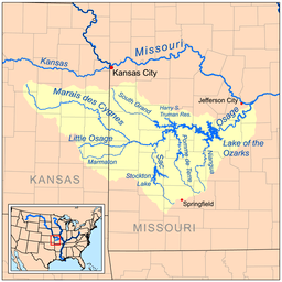 Map of the Osage River watershed showing the Niangua River | |
The Niangua River /naɪˈæŋɡwə/ is a 125-mile-long (201 km)[3] tributary of the Osage River in the Ozarks region of southern and central Missouri in the United States. Via the Osage and Missouri rivers it is part of the watershed of the Mississippi River.
Course
The Niangua River is formed in Webster County by the confluence of its short east and west forks, and flows generally northward through Dallas, Laclede and Camden counties, past Bennett Spring, Lake Niangua, and Ha Ha Tonka State Parks. It flows into the Osage River as an arm of the Lake of the Ozarks, which is formed by the Bagnell Dam on the Osage. As part of the lake it collects the Little Niangua River.
River accesses
This is a list of areas where the Niangua River can be publicly accessed; this list was put in order from beginning of river to where river meets up with Lake of the Ozarks.
- Charity Access- State-owned river access; no camping allowed.
- Cline Ford
- Hico Slab- Where a road crosses the river; the bridge is basically a low-lying concrete slab with water tunnels.
- Del Marlin Ford
- Deusenberry Creek
- Gaunt Ford
- Crane Ford
- Route 32 Bridge
- Big John Access- State-owned river access.
- Wimberly Ford
- Dallion Ford
- Hackler Ford
- Williams Ford Access- A one lane road crossing; crossing is a concrete slab where water flows over the top.
- Hwy. K-P Bridge Access- Access includes privately owned campground, picnic area, and shuttle service.
- Moon Valley Access- State-owned river access.
- Hildebrand Ford
- Cat Hollow- Privately owned campground and cabins nearby.
- Route 64 Bridge
- Bennett Spring Access- State-owned river access.
- Barclary Springs- State-owned river access.
- Gilbertson Ford
- Prosperine Access- State-owned river access.
- Mountain Creek- Access includes privately owned campground, picnic area, cabins and shuttle service.
- McPheters Ford
- Smith Ford
- Leadmine Conservation Area- State-owned river access and conservation area; primitive camping allowed.
- Lake Niangua- Includes access and picnic area; no camping allowed.
- Whistle Bridge- Low-lying river crossing where road crosses river.
- Stone Ford
- Ha Ha Tonka State Park- State-owned river access; this is where the river merges into Lake of the Ozarks.
See also
References
- ↑ "Niangua River". Geographic Names Information System. United States Geological Survey. Retrieved 2015-12-03.
- ↑ "Water-Data Report 2012 - 06923950 Niangua River at Tunnel Dam near Macks Creek, MO" (PDF). U.S. Geological Survey. Retrieved 2015-12-03.
- ↑ U.S. Geological Survey. National Hydrography Dataset high-resolution flowline data. The National Map, accessed May 31, 2011
- Columbia Gazetteer of North America entry
- DeLorme (2002). Missouri Atlas & Gazetteer. Yarmouth, Maine: DeLorme. ISBN 0-89933-353-2.
- U.S. Geological Survey Geographic Names Information System: Niangua River