Nice tramway
|
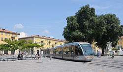
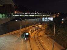
Tram crossing Place Garibaldi, where it lowers its pantograph and is powered by batteries. | |
| Overview | |
|---|---|
| Native name | Tramway de Nice |
| Locale | Nice, Provence-Alpes-Côte d'Azur, France |
| Transit type | Light rail tram |
| Number of lines | 1 |
| Number of stations | 21 |
| Daily ridership | 70,000 (2010) |
| Operation | |
| Began operation | 2007 |
| Operator(s) | Veolia Transdev |
| Technical | |
| System length | 8.7 km (5.4 mi) |
| Track gauge | 1,435 mm (4 ft 8 1⁄2 in) standard gauge |
| Electrification | 750 V DC Overhead line |
The Nice tramway (French: Tramway de Nice) is a 8.7-kilometre (5.4 mi), single-line tramway in the city of Nice in Provence-Alpes-Côte d'Azur, France. It is operated by the Société nouvelle des transports de l'agglomération niçoise division of Veolia Transdev[1] under the name Lignes d'azur.
Opened on 24 November 2007, it replaced bus lines 1, 2, 5 and 18. From the start, the system had 20 Alstom Citadis trams in service, providing a tram every seven minutes. Since its inception, the number of passengers has increased from 70,000 per day in 2008 to 90,000 per day in 2011. The frequency has gradually increased to a tram every four minutes in 2011.
Given the success of the T1 line, mayor of Nice Christian Estrosi decided to create additional lines. The West-East Line is to serve the Nice airport to the west through the construction of a multimodal center and the Port of Nice to the east. This line will run through a tunnel in the center of Nice. A future extension of the West-East line, north along the Var valley, is proposed. Another extension, running further west from the airport, across the Var, is also proposed.[2] In addition, the Nice Côte d'azur urban region decided to extend line 1 to the Pasteur neighborhood.
History
1900–53
The first tramway in Nice opened in 1879, was electrified in 1900, and was followed by a departmental network in 1906. The entire network was electrified in 1910. In the 1920s, the network had 11 lines, some of which were partially used for goods transport. However, the tram was criticised and was replaced by buses on some lines beginning in 1927. The last tramway in Nice ceased service on 10 January 1953.
Current tramline
Like many other French cities, Nice has major traffic problems, including the fact that most economic activities are concentrated in the centre. To overcome these problems, studies on the implementation of transit in dedicated lanes were conducted in 1987. The city of Nice began to implement dedicated bus lanes in 1997, and launched a study on the implementation of a tram line in 1998.
Trams were chosen because they appeared to be more reliable than buses, since they are not subject to the vagaries of traffic, but they are less expensive than a subway line. The tram was declared a public utility in 2003 and work began the same year; the line was placed in service on 24 November 2007 after several weeks of technical trials, even though construction was not fully completed.
In the months following the launch of the tram, there were between 65,000 and 70,000 passengers daily;[3] the number rose to 90,000 by January 2011.[4]
Network
The Nice tramway was designed to serve most of the population of Nice. As the city is situated on hilly ground by the sea, the line was drawn as a U shape, passing through the city centre.
There is currently only one line, served by two termini: Henri Sappia and Hopital Pasteur. A second line, connecting the city centre with the airport and the Central Business District (CADAM, Arénas), is under construction.
Henri Sappia terminus
Formerly called "Las Planas",[5] the north-western terminus of the tramway was renamed "Henri Sappia" in July, 2013. The Henri Sappia depot is situated at the northwestern terminus of the line in the neighbourhood of Le Rouret, where the Count of Falicon and the Marquis of Rouret once owned large villas and many farms dotted the land.
Above the tram terminus sport and cultural centres have been built. The plaza in front of the station has been raised and planted, with a fountain of water jets installed.
Fontaine du Temple
The Fontaine du Temple neighbourhood where the Comte de Falicon tram stop is built has been remodelled for the arrival of the tramway. The plaza has been repaved and will host an outdoor market.
Planned extensions

Line 2 will run for 11.3 km of which 3.2 km near the center are going to be underground. Starting at the port in the east and ending at Nice Côte d'Azur Airport and Nikaïa in the west, serving 20 stations in total. Ridership expectations are 140,000 passengers per day. Work is to begin in the second half of 2014. A €270m contract for building the underground section has been awarded in December 2013.[6] As of September 2016, service from CADAM to Magnan is planned to start operating in mid-2018, service to the airport and Jean Médecin station is planned for late 2018, and service on the complete line is planned for 2019. [7] The total cost of the line is projected to be €770m of which the central government is contributing €52.8m.
Tram and art
Art works are used throughout the line, including sculptures of figures by Jaume Plensa, on the top of pylons on the Place Massena. Michel Redolfi designed the sound system. Artists Benjamin Vautier, known as "Ben" (who designed the station name signs), the Mado la Niçoise, Michael Lonsdale and others make voice announcements inside the tram. Sounds and voices are different depending on the hours, seasons, etc. The thirteen artists selected to decorate the tramway are:[8]
- Ben (Benjamin Vautier)
- Michael Craig-Martin
- Gunda Förster
- Yann Kersalé
- Ange Leccia
- Stéphane Magnin
- Maurizio Nannucci
- Jean-Michel Othoniel
- Pascal Pinaud
- Jaume Plensa
- Emmanuel Saulnier
- Pierre di Sciullo
- Sarkis Zabunyan
- Jacques Vieille.
Rolling stock
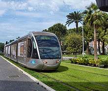
The cars of the Nice tramway are unique and have been designed to blend in with the Niçois architecture. They are based on the Alstom Citadis family of tramcars and were built near La Rochelle, Poitou-Charentes. A standard 5-car tram measures 35 m (114 ft 10 in) but extra carriages may be added, bringing the length to 45 m (147 ft 7 5⁄8 in). The tram is 2.65 m (8 ft 8 3⁄8 in) wide and can carry 200 passengers at 18 km/h (11 mph) compared to 11 km/h (6.8 mph) for the bus. It uses the 1,435 mm (4 ft 8 1⁄2 in) standard gauge .
Power supply
Nice tramway was originally to use the ground-level power supply third rail system as used by Bordeaux tramway. However, this was abandoned in favour of the more conventional overhead power supply cables providing 750 V DC, except where the tram crosses the Place Masséna and Place Garibaldi, when it lowers its pantograph and relies on its onboard nickel metal hydride batteries to cross these large open spaces, where overhead wires would be an eyesore.[9]
See also
References
- ↑ "Qui sommes-nous? : La gestion des transports La société S.T.2.N. filiale de Veolia Transdev" (in French). Lines d'azur. Retrieved 2013-03-10.
- ↑ "Le tracé de la ligne Ouest-Est" (in French). Tramway de la Métropole Nice Côte d’Azur. Retrieved 2016-09-21.
- ↑ Beal, Sylvie (30 May 2008). "Nice - La ligne 2 du tram : tout de suite, plus tard, jamais ?". Nice-Matin (in French). Nice: Nice Matin Group. Retrieved 2011-07-14.
- ↑ Casals, Sophie (20 January 2011). "Bus: ça roule, mais...". Nice-Matin (in French). Nice: Nice Matin Group. Retrieved 2011-07-14.
- ↑ "Le terminus "Las Planas" change de nom et devient "Henri Sappia"" (in French). Tramway de la Métropole Nice Côte d’Azur. Retrieved 2013-09-17.
- ↑ "Contract awarded for Nice tram Line 2". Railway Gazette International. 18 November 2013. Retrieved 2014-07-21.
- ↑ "Tout sur le projet" (in French). Tramway de la Métropole Nice Côte d’Azur. Retrieved 2016-09-21.
- ↑ "L'art dans la ville, avec le tramway Nice Côte d'Azur" (pdf). agglo-nice.fr (in French). Retrieved 2011-07-11.
- ↑ "Nice Tramway, France". Railway-Technology.com. Retrieved 2014-05-30.
External links
| Wikimedia Commons has media related to Trams in Nice. |
- Nice tramway – official website (French)
- ST2N – official website (French)
Coordinates: 43°41′49.36″N 7°16′13.35″E / 43.6970444°N 7.2703750°E