Niinivesi
| Niinivesi | |
|---|---|
 | |
| Location | Rautalampi, Tervo, Vesanto |
| Coordinates | 62°37′18″N 26°50′00″E / 62.62167°N 26.83333°ECoordinates: 62°37′18″N 26°50′00″E / 62.62167°N 26.83333°E |
| Type | Lake |
| Primary outflows | Nokisenkoski rapids |
| Catchment area | Kymijoki |
| Basin countries | Finland |
| Max. length | 35 km (22 mi) |
| Surface area | 75.66 km2 (29.21 sq mi) |
| Max. depth | 19.22 m (63.1 ft) |
| Shore length1 | 196.31 km (121.98 mi) |
| Surface elevation | 97.9 m (321 ft) |
| Frozen | December–April |
| Islands | Kotasaari, Papinsaari |
| References | [1] |
| 1 Shore length is not a well-defined measure. | |
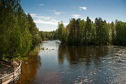
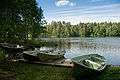
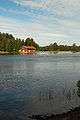
Niinivesi is a medium-sized lake of Finland and it belongs to the Kymijoki main catchment area. The lake is situated in Rautalampi, Tervo and Vesanto municipalities.[1] Niinivesi is almost divided into northern and southern part. The northern part is 20 kilometer long and narrow bay. The southern part is connected westwards to the lake Kiesimä via Kerkonkoski Canal. The water quality in the lake is excellent and clear.
References
- 1 2 Lake Niinivesi in the Jarviwiki Web Service (English)

See also
| Wikimedia Commons has media related to Lake Niinivesi. |
This article is issued from Wikipedia - version of the 9/4/2015. The text is available under the Creative Commons Attribution/Share Alike but additional terms may apply for the media files.