Niterói
| Niterói | |||
|---|---|---|---|
| Municipality | |||
| Municipality of Niterói | |||
|
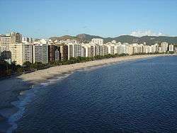
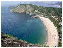
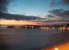
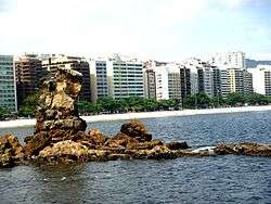
View of Icaraí Beach | |||
| |||
| Nickname(s): Cidade Sorriso (Smile City) | |||
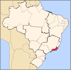
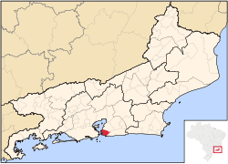 Location of Niterói | |||
| Coordinates: 22°52′58″S 43°06′14″W / 22.88278°S 43.10389°W | |||
| Country | Brazil | ||
| Region | Southeast | ||
| State | Rio de Janeiro | ||
| Founded | 22 November 1573 | ||
| Incorporated | 1835 | ||
| Government | |||
| • Mayor | Rodrigo Neves (PV) | ||
| Area | |||
| • Municipality | 129.38 km2 (49.95 sq mi) | ||
| Elevation | 0 m (0 ft) | ||
| Population (2010)[1] | |||
| • Municipality | 487,327(39th) | ||
| • Density | 3,684.4/km2 (9,543/sq mi) | ||
| • Metro | 12,620,000 (As part of the Rio de Janeiro City's metropolitan region) | ||
| Time zone | UTC-3 (UTC-3) | ||
| • Summer (DST) | UTC-2 (UTC-2) | ||
| Postal Code | 24000-000 | ||
| Area code(s) | 21 | ||
| Website | Niterói, Rio de Janeiro | ||
Niterói (Portuguese pronunciation: [niteˈɾɔj]) is a municipality of the state of Rio de Janeiro in the southeast region of Brazil. It lies across Guanabara Bay facing the city of Rio de Janeiro and forms part of the Rio de Janeiro Metropolitan Area.[2] It was the state capital, as marked by its golden mural crown, between 1834~1894 and again between 1903~1975. It has an estimated population of 487,327 inhabitants (2010) and an area of 129.375 km (80.39 mi), making it the sixth most populous city in the state. It has the highest Human Development Index of the state. The city has the nicknames of Nikity, Nicki City and the Smile City (Cidade Sorriso).
Studies by the Getulio Vargas Foundation in June 2011 classified Niterói as the richest city of Brazil, with 55.7% of the population included in class A. Considering the classes A and B, Niterói also appears in the first place, with 85.9% of the population in these classes.
The word "Niterói" comes from the Tupi language and means "water that hides". It was founded on 22 November 1573 by the Tupi Amerindian chief Araribóia (who later was converted to Roman Catholicism and given the Christian name of Martim Afonso, after the Portuguese explorer Martim Afonso de Sousa). It makes Niteroi the only Brazilian city to have been founded by a non-Christian, non-assimilated Brazilian Amerindian.[3]
History
Following the expulsion of French settlers from Rio de Janeiro in 1567 by Estácio de Sá (the so-called France Antarctique episode), the Portuguese crown began noticing that the bay of Rio de Janeiro would make a strategic scale for the Atlantic route of ships from Portugal to its colonies in Africa and Asia, as well an important advanced bridgehead for the defense of South Brazil. Fortresses were built and an alliance was formed with nearby native Tupi-Guaraní tribes to defend the settlement against other European invaders.
Araribóia, the chief of one of these allied tribes – the Temininós – requested from the Portuguese Governor-General of Brazil, Mem de Sá, a tract of land; his request was granted, and he was rewarded with the region called "Banda D'Além" (the land beyond), in the eastern side of the bay, from River Marui to the Red Barriers between Gragoata and Boa Viagem beaches.[4] This area corresponded to what is nowadays the northwestern part of the municipality of Niterói, which includes the central and northern zones of its urban area. There, in the "Land Beyond", Araribóia founded the Town of Saint Lawrence of the Indians (in Portuguese, Vila de São Lourenço dos Índios), the embryo for the future city of Niterói, a Tupi name that means "Hidden Waters".
The village was visited by the king of Portugal, John VI, in 1816, who also decreed its emancipation from Rio de Janeiro on 10 May 1819 and gave the new-created municipality a new name, Vila Real da Praia Grande (Royal Town of Great Beach).
In 1834, the city of Rio de Janeiro, capital of the newly established Empire of Brazil, was detached from the rest of Rio de Janeiro Province; Vila Real da Praia Grande was then chosen as the new capital of that province, while the city of Rio de Janeiro itself was converted into a neutral municipality, following the Ato Adicional. Niterói served the function of capital till the year of 1975 – except for the period between 1894 and 1903 when it was temporarily transferred to the city of Petrópolis.
Vila Real da Praia Grande was officially renamed to Niterói on 6 March 1835 after the Tupi Nictheroy (hidden waters). This old spelling persisted until the mid-20th century, when the current spelling – Niterói – was adopted.
In 1890, the Brazilian provinces began being called states and the neutral municipality (Rio de Janeiro city) had its status changed to Federal District (or simply DF, the Brazilian acronym for Distrito Federal). Following the transference of Brazil's capital to Brasília in 1960, the city of Rio de Janeiro became a city-state named Guanabara. This state was merged with Rio de Janeiro State in 1975; since then, Niterói lost its condition of the state's capital in favor of the city of Rio de Janeiro.
A circus fire in the city killed 323 people on 17 December 1961; the fire was later found to have been deliberately set by disgruntled circus employees. It is one of the worst tragedies in Brazilian history and the most fatal in the annals of world circus show history.
On 8 April 2010; the mudslide triggered due to heavy rainfall cost at least 200 lives. At least 11,000 people were forced to flee homes due to further mudslides.[5]
Growth
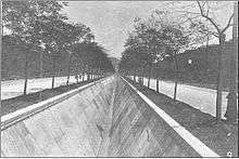
By the time of its emancipation, the urban area of Niteroi corresponded to its central zone and São Domingos only. The south zone – Icarai, Santa Rosa, Vital Brazil – began being urbanized in 1841, when the Santa Rosa farm was divided into estates, while Jurujuba evolved from an old fishermen colony. São Francisco and Charitas, sites named after the Catholic Church built in honor to Saint Francis by the Jurujuba cove, remained sparsely populated till about 1940. As for the northern zone of Niteroi, its urbanization began in the late 19th century, when a tramway was inaugurated, allowing the expansion of the city to north and northeast, as well boosting the urban growth of the neighbour county of São Gonçalo.
The realm of Itaipu – a former vast zone of farming lands and forests west to Niteroi – was annexed to the county in 1943. It has lost its countryside traits and its urban population has grown fast since the late 1960s.
In the early 20th century, Niteroi started its industrialization boom.
Economy
Niteroi is one most important financial and commercial centers in Rio de Janeiro State, like a modern city, with modern buildings and several shopping malls. Its economy is centered on its trading and commerce services, like imobiliary corporations, graphic design, web design and publicity. It also hosts industries of food (especially seafood), clothes, caldle, marine objects;
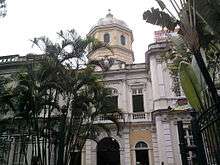
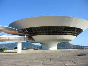
The city is located 25 minutes away from Rio de Janeiro's downtown region. Niterói boasts the title of fourth richest city in the state, and the third in Rio de Janeiro City Metropolitan Area. The Niterói Contemporary Art Museum, the city's main landmark, was designed by the famous Brazilian modernist architect Oscar Niemeyer. The landscape of the central urban area of the city is dominated by the Niterói Tower, a tall cylindrical office building belonging to the Niterói Shopping Mall.
Demographics
Niteroi is 14 km (8.7 mi) distant from Rio de Janeiro City, to which it is linked by the Rio-Niterói bridge and two ferry-boat services. According to the 2010 Brazilian Census, the city has a population of 487,320 people, making it the sixth most populous city in the state of Rio de Janeiro and the 39th most populous in the country. At the 2010 Census, the population of Niterói grew 9.3% from 2000 to 2010, meaning Niterói had the lowest city population growth in the state of Rio de Janeiro in this period.
The quality of life of the municipality of Niteroi is considered one of the best (third place) among 5,600 other Brazilian municipalities, according to UN indexes (2000 est.).
| Year | Population |
|---|---|
| 1950 | 698,582 |
| 1970 | 513,771 |
| 1990 | 431,070 |
| 2000 | 459,451 |
| 2010 | 487,327 |
The population in Niteroi in 2010 was 487,327, down from the 698,582 in 1950, but with an increase compared to 2000, of 9%. According to the Census in 2010, whites were 73.6%, multiracial 19.1%, black 4% and Asian 3%. Non-Brazilians of any race were 1% of population, down from the 36% in 1950. Niterói is a town with a high quality of life and a centre of agglomerate made up by rich families. In 2010, "Class A" people were 32% (the highest index in Brazil, while 14.8% were in the poverty line, less than cities like Detroit, Miami, Cleveland and Philadelphia. Homes in the "Ghetto type" were 27% (Favelas 6%), less than Rio de Janeiro (37.5% "Ghetto type" with 11% made up Favelas).
Education
Niteroi is the seat of the Fluminense Federal University, one of the most important research centers in Brazil.[6] It does have other colleges such as ISE La Salle and Candido Mendes University.
Catholic schools, mainly La Salle Institute and São Vicente de Paulo, are the most traditional elementary and high schools of the city. Other important schools are PH, Marília Matoso, Pedro II, Gay Lussac, Colégio Nossa Senhora Das Mercês, the Salesian High School, ETE – Henrique Lage (a.k.a. Faetec), and Oswaldo Cruz Institute.
Niterói has the highest Human Development Index (HDI) and best level of literacy in the State of Rio de Janeiro.[7]
Politics
Current mayor of Niterói is Rodrigo Neves of the Workers' Party was elected in 2012 for a four-year term.
Administrative divisions
From 1943 to the late 1970s, the county of Niteroi comprised two districts only: the district of Niteroi (original area) and the district of Itaipu (acquired in 1943), which barely had an urban continuity or even proper road links to each other and were considered apart areas. The fractioning of Itaipu's farms into real estates as well its imobiliary boom after the building of the Rio-Niterói's bridge demanded a better integration between the two sides of the county which led to the improving of the roads and urban facilities and a reformation on the make up of Niteroi's administrative division. The county was reorganised into five districts. In the early 1990s, the administrative division of Niterói was altered once again, being the county now divided into twelve administrative, further subdivided into 48 neighborhoods.
|
|
Notable people from Niterói
- Patricia Acioli – judge; feminist
- Alex Rodrigo Dias da Costa – footballer
- André Marques – TV show host, entertainer
- Arthur Maia – musician (bass player)
- Baby Consuelo – singer
- Benjamin Constant – politician
- Bonde Das Maravilhas - funk carioca dancers
- Bruno Beltrão – choreographer
- Cenira Sampaio - footballer
- Daniel Lins Cortês – footballer
- Dedé Santana – comedian
- Edmundo – footballer
- Fernanda Keller – triathlete, iron-man winner
- Fernanda Young – writer, TV entertainer, actress
- Francisco Frias – guitarist, composer, also known in Niteroi as Bolinha
- Gérson – footballer
- Gustavo Beaklini – harpist
- Isaac Bardavid – actor and dubber
- Leonardo – Paris Saint-Germain F.C. Manager.
- Leila Diniz - actress
- Luciane Valença - visual artist
- Marcello Antony – actor
- Marcelo Ferreira – athlete (sailing), Olympic medallist
- Marcia Haydée – Ballerina, choreographer and ballet director
- Matheus Fernandes – singer
- Murilo Benício – actor
- Mylena Ciribelli – journalist
- Perla Haney-Jardine – actress
- Raica Oliveira – top model
- Ricardo Arona – fighter
- Sérgio Mendes – musician, songwriter
- Rodrigo Barreto aka Rod B. - dj, edm producer
- Torben Grael and Lars Grael – athletes (sailing), Olympic medallists
- Dr Cesar Nahoum – famous doctor
- Jô Bilac - Playwright
References
- ↑ "Censo Populacional 2010". Censo Populacional 2010. Instituto Brasileiro de Geografia e Estatística (IBGE). 29 November 2010. Archived from the original on 16 May 2011. Retrieved 11 December 2010.
- ↑ Rio de Janeiro to Niteroi, Brazil - Google Maps
- ↑ "The Niterói Secretary of Culture's official website". Niterói City Hall. Retrieved 2007-02-25.
- ↑ Conheça Niterói (Know Niterói)
- ↑ "Fears Rio mudslide toll could soar – Americas". Al Jazeera English. Retrieved 2013-03-26.
- ↑ UFF in numbers
- ↑ Fundação Municipal de Educação de Niterói
External links
| Wikimedia Commons has media related to Niterói. |
| Wikisource has the text of the 1905 New International Encyclopedia article Nictheroy. |
 Niterói travel guide from Wikivoyage
- History of the city of Niterói
- Niterói Tourism Official Web Site
- A guide to the city of Niterói
- Satellite picture by Google Maps
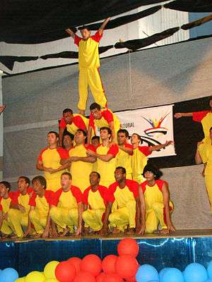
- Gymnastic formation squadron of Niteroi, Nov. 2009
- Amo Niterói
- Parque da Cidade - Paragliding take off ramp.
Coordinates: 22°53′00″S 43°06′13″W / 22.88333°S 43.10361°W
Capital: Rio de Janeiro | |||||||||||||||||||
| Mesoregion Baixadas |
|  | |||||||||||||||||
| Mesoregion Centro Fluminense |
| ||||||||||||||||||
| Mesoregion Metropolitana do Rio de Janeiro |
| ||||||||||||||||||
| Mesoregion Noroeste Fluminense |
| ||||||||||||||||||
| Mesoregion Norte Fluminense |
| ||||||||||||||||||
| Mesoregion Sul Fluminense |
| ||||||||||||||||||