Nonette (river)
| Nonette | |
|---|---|
 | |
| Country | France |
| Basin | |
| River mouth |
Oise 49°12′10″N 2°23′59″E / 49.20278°N 2.39972°ECoordinates: 49°12′10″N 2°23′59″E / 49.20278°N 2.39972°E |
| Progression | Oise→ Seine→ English Channel |
| Physical characteristics | |
| Length | 40 km (25 mi) |
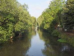
The Nonette is a tributary to the river Oise in northern France.[1] Its source is in Nanteuil-le-Haudouin, from which it flows west through Senlis and Chantilly, and joins the Oise in Gouvieux.[2]
The river has relatively high turbidity and its brownish water has a modest in velocity due to the slight gradient of the watercourse; pH levels have been measured at 9.25 or quite alkaline[3] near the Château d'Ermenonville and electrical conductivity of the waters have tested at 81 micro-siemens per centimetre.
References
- ↑ Atlas des Routes de France, Solar Press: Donnees IGN (2007)
- ↑ Sandre (2010). "River Nonette" (in French). French National Service for Water Data and Common Repositories Management. Retrieved 30 January 2012.
- ↑ Hogan, C. Michael, Water quality of freshwater bodies in France, Lumina Tech Press, Aberdeen (2006)
This article is issued from Wikipedia - version of the 6/7/2016. The text is available under the Creative Commons Attribution/Share Alike but additional terms may apply for the media files.