Nong Bua District
| Nong Bua หนองบัว | |
|---|---|
| Amphoe | |
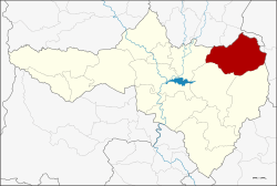 Amphoe location in Nakhon Sawan Province | |
| Coordinates: 15°51′54″N 100°35′10″E / 15.86500°N 100.58611°ECoordinates: 15°51′54″N 100°35′10″E / 15.86500°N 100.58611°E | |
| Country |
|
| Province | Nakhon Sawan |
| Area | |
| • Total | 819.5 km2 (316.4 sq mi) |
| Population (2005) | |
| • Total | 70,609 |
| • Density | 86/km2 (220/sq mi) |
| Time zone | THA (UTC+7) |
| Postal code | 60110 |
| Geocode | 6004 |
Nong Bua (Thai: หนองบัว) is a district (amphoe) in the northeastern part of Nakhon Sawan Province, northern Thailand.
History
The government separated some tambons of the districts Chum Saeng, Tha Tako and Bang Mun Nak of Phichit Province to create the minor district (King Amphoe) Nong Bua on January 1, 1948. It was upgraded to a full district on June 6, 1956.
Geography
Neighboring districts are (from the north clockwise) Bang Mun Nak and Dong Charoen of Phichit Province, Chon Daen and Bueng Sam Phan of Phetchabun Province, and Phaisali, Tha Tako and Chum Saeng of Nakhon Sawan Province.
Administration
The district is subdivided into 9 subdistricts (tambon), which are further subdivided into 105 villages (muban). Nong Bua is a township (thesaban tambon) covering parts of the tambon Nong Bua and Nong Klap. There are further 9 Tambon administrative organizations (TAO).
| No. | Name | Thai name | Villages | Pop. |
|---|---|---|---|---|
| 1. | Nong Bua | หนองบัว | 20 | 15,342 |
| 2. | Nong Klap | หนองกลับ | 15 | 13,103 |
| 3. | Than Thahan | ธารทหาร | 9 | 7,977 |
| 4. | Huai Ruam | ห้วยร่วม | 11 | 4,595 |
| 5. | Huai Thua Tai | ห้วยถั่วใต้ | 7 | 2,178 |
| 6. | Huai Thua Nuea | ห้วยถั่วเหนือ | 9 | 3,580 |
| 7. | Huai Yai | ห้วยใหญ่ | 6 | 2,938 |
| 8. | Thung Thong | ทุ่งทอง | 14 | 9,876 |
| 9. | Wang Bo | วังบ่อ | 14 | 11,020 |