North Carolina Highway 711
| ||||
|---|---|---|---|---|
 | ||||
| Route information | ||||
| Maintained by NCDOT | ||||
| Length: | 11.7 mi[1] (18.8 km) | |||
| Existed: | 1952 – present | |||
| Major junctions | ||||
| South end: |
| |||
| North end: |
| |||
| Location | ||||
| Counties: | Robeson | |||
| Highway system | ||||
| ||||

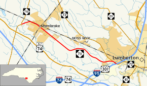
North Carolina Highway 711 (NC 711) is a primary state highway in the Robeson County, North Carolina. It connects the town of Pembroke with Interstate 95 (I-95) and U.S. Route 301 (US 301) in Lumberton. The road travels in a east-to-west orientation but is signed as a north-south highway (with its easternmost point in Lumberton as its southern terminus).
Route description
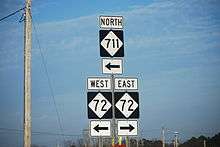
NC 711 is a predominantly two-lane highway that travels from I-95/US 301 in Lumberton to NC 710 in Pembroke. South of the I-95 interchange, the road continues to the east towards downtown Lumberton as NC 72. NC 711 and NC 72 share a concurrency for 1⁄2 mile (0.80 km) north of the interchange. Two key features of the route is its crossing of the Lumber River near its southern terminus and its pass-by of University of North Carolina at Pembroke in downtown Pembroke.
History
NC 711 was established in 1951 or 1952 as a reestablishment of a primary highway between Lumberton and Pembroke. The route previously existed as US 74, but was downgraded to a secondary road when it was rerouted south onto new bypass south of the Lumber River in 1949. The original routing was from NC 72 to NC 710.[2] Between 1963-1968, NC 711 was extended south, overlapping NC 72 to its current southern terminus with I-95/US 301.[3][4]
Junction list
The entire route is in Robeson County.
| Location | mi[1] | km | Destinations | Notes | |
|---|---|---|---|---|---|
| Lumberton | 0.0 | 0.0 | East end of NC 72 overlap; exit 17 (I-95) | ||
| 0.5 | 0.80 | West end of NC 72 overlap | |||
| Pembroke | 11.7 | 18.8 | |||
1.000 mi = 1.609 km; 1.000 km = 0.621 mi
| |||||
References
- 1 2 Google (June 12, 2014). "North Carolina Highway 711" (Map). Google Maps. Google. Retrieved June 12, 2014.
- ↑ North Carolina Official Highway Map (PDF) (Map). Cartography by NCDOT. North Carolina Department of Transportation. 1951. Retrieved June 12, 2014.
- ↑ North Carolina County Maps (PDF) (Map). Cartography by North Carolina State Highway Commission. North Carolina Department of Transportation. 1962. Robeson County inset. Retrieved June 12, 2014.
- ↑ North Carolina County Maps (PDF) (Map). Cartography by North Carolina State Highway Commission. North Carolina Department of Transportation. 1968. Robeson County inset. Retrieved June 12, 2014.
External links
-
 Media related to North Carolina Highway 711 at Wikimedia Commons
 - NCRoads.com: N.C. 711