North Eaglenest Mountain
| North Eaglenest Mountain | |
|---|---|
 | |
| Highest point | |
| Elevation | 5,075 ft (1,547 m) [1] |
| Coordinates | 35°30′02″N 83°02′30″W / 35.50056°N 83.04167°WCoordinates: 35°30′02″N 83°02′30″W / 35.50056°N 83.04167°W [1] |
| Geography | |
 North Eaglenest Mountain | |
| Parent range | Appalachian Mountains |
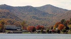
North Eaglenest Mountain is a mountain located less than 2 miles south of Maggie Valley, North Carolina in Haywood County. It is part of the Plott Balsams, a range of the Appalachian Mountains, and less than a mile north of Eaglenest Mountain. It used to be called Mount Junaluska and is the highest mountain overlooking Lake Junaluska from the west.
In 1900, S. C. Satterthwait of Waynesville, North Carolina, which was 5 miles away, built the Eagle Nest Hotel at an elevation of 5050 feet. The location was a mountain range he called The Junaluskas,[2] on a peak called Mount Junaluska.[3] The hotel was one of the two hay fever resorts in western North Carolina, the other being Cloudland on Roan Mountain, and it had room for 100 guests (although tents could be used if the hotel filled up) and a view of Plott Balsam. "[A] good wagon road" reached the top of the mountain.[2]
References
- 1 2 "North Eaglenest Mountain". Geographic Names Information System. United States Geological Survey. Retrieved 2009-04-17.
- 1 2 http://www.heritagewnc.org/WNC_hotels_ABE/eagle_nest.htm, Retrieved on 2009-04-14.
- ↑ Webb, Janet Threlkeld (2006). Haywood County: A Brief History. The History Press. p. 30. ISBN 9781596291751. Retrieved 2009-04-16.
External links
- Topographic map of Eaglenest Mountain and North Eaglenest Mountain
- Topographic map showing Eaglenest Ridge
- Ad for Eaglenest Hotel