North Lantau Highway
| |
|---|---|
| Part of Route 8 | |
|
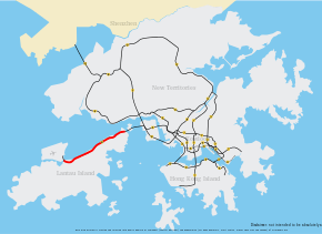
North Lantau Highway coloured red | |
| Route information | |
| Maintained by Highways Department | |
| Length: | 12.8 km (8.0 mi) |
| Existed: | 1997 – present |
| Major junctions | |
| West end: | Chek Lap Kok |
| East end: | Lantau (near Yam O) |
| Highway system | |
| Hong Kong Strategic Route and Exit Number System | |

| North Lantau Highway | |||||||||||||||
| Traditional Chinese | 北大嶼山公路 | ||||||||||||||
|---|---|---|---|---|---|---|---|---|---|---|---|---|---|---|---|
| Simplified Chinese | 北大屿山公路 | ||||||||||||||
| |||||||||||||||
.jpg)
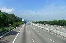
North Lantau Highway (traditional Chinese: 北大嶼山公路; simplified Chinese: 北大屿山公路) is an expressway forming part of Hong Kong's Route 8, linking Hong Kong International Airport and Lantau Island with the rest of the territory. The road has three lanes in each direction for its entire length with full-width hard shoulders for emergencies and breakdowns. The speed limit is 110 kilometres per hour (68 mph), the highest of any road in Hong Kong.
North Lantau Highway is 12.5 kilometres (7.8 mi) in length, beginning at Airport Road on Chek Lap Kok. The road then crosses onto Lantau Island and bypasses Tung Chung New Town. The road then travels along the northern coast of Lantau Island, next to the Airport Express and Tung Chung Line of the MTR. This section is built on reclaimed land and through various cuttings. Finally, the road climbs over Ta Shui Wan and Tsing Chau Wan to meet the Lantau Link and its bridges.
Interchanges
| North Lantau Highway | ||
| Eastbound exits | Exit number | Westbound exits |
| | ||
| End North Lantau Highway |
Start North Lantau Highway | |
| Sunny Bay, Discovery Bay, Hong Kong Disneyland Penny's Bay Highway |
5 | Sunny Bay, Discovery Bay, Hong Kong Disneyland Penny's Bay Highway |
| Siu Ho Wan MTR Depot | 6 | Siu Ho Wan MTR Depot |
| no exit | 6A | TUNG CHUNG EASTERN INTERCHANGE Tung Chung Town Centre Yi Tung Road, Yu Tung Road |
| no exit | 6B | Tung Chung North Tung Chung Waterfront Road |
| Start North Lantau Highway |
End North Lantau Highway End of Route 8 merges with Airport Road | |
Flooding
On 7 June 2008, North Lantau Highway and its service road, Cheung Tung Road, were completely flooded at Caribbean Coast, Tung Chung at 6am, under rainfall as high as 145 mm (5.7 in) per hour. The highway was forced to close completely, rendering Hong Kong International Airport at Chek Lap Kok inaccessible by road. With a water depth of 3 metres (9.8 ft), and the flood extending 500 metres (550 yd) in length, some 20 vehicles were trapped on the scene by the floodwater. Another thousand vehicles were trapped in the resulting traffic jam, extending about 10 km (6.2 mi) back to the toll plaza of Lantau Link. Service was increased on the MTR Tung Chung Line and Airport Express to alleviate passenger flow.
The highway was partially reopened starting from 4pm that day.[1][2]
References
- ↑ "百年一遇 暴雨沖潰機場命脈 北大嶼山公路成河道 交通癱瘓10小時". Ming Pao. 2008-06-08.
- ↑ "洪水五秒癱瘓機場公路". Sing Tao Daily. 2008-06-08.
External links
-
 Media related to North Lantau Highway at Wikimedia Commons
Coordinates: 22°18′51″N 113°59′33″E / 22.3143°N 113.9924°E
| Preceded by Lantau Link |
Hong Kong Route 8 North Lantau Highway |
Succeeded by Western Terminus |