North Norfolk
| North Norfolk District Council | |
|---|---|
| District | |
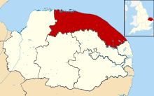 Shown within Norfolk | |
| Sovereign state | United Kingdom |
| Constituent country | England |
| Region | East of England |
| Administrative county | Norfolk |
| Formed |
1 April 1974 Local Government Act 1972 |
| Admin. HQ | Cromer |
| Government | |
| • Type | North Norfolk District Council |
| • Leadership: | Leader & Cabinet |
| • Executive: | Conservative |
| • MPs: |
Norman Lamb (LD) Keith Simpson (C) |
| Area | |
| • Total | 372.0 sq mi (963.4 km2) |
| Area rank | 28th |
| Population (mid-2014 est.) | |
| • Total | 102,867 |
| • Rank | Ranked 226th |
| • Density | 280/sq mi (110/km2) |
| Time zone | Greenwich Mean Time (UTC+0) |
| • Summer (DST) | British Summer Time (UTC+1) |
| ONS code |
33UF (ONS) E07000147 (GSS) |
| Ethnicity | 99.2% White |
| Website | north-norfolk.gov.uk |
North Norfolk is a local government district in Norfolk, United Kingdom. Its council is based in Cromer. The council headquarters can be found approximately 1 mile (1.6 km) from the town centre of Cromer on the road to Holt and there is a smaller office for callers in Fakenham. The population of the Local Authority District at the 2011 Census was 101,149. [1]
History
The district was formed on 1 April 1974, under the Local Government Act 1972. It was a merger of Cromer Urban District, North Walsham Urban District, Sheringham Urban District, Wells-next-the-Sea Urban District, Erpingham Rural District, Smallburgh Rural District, and Walsingham Rural District.
The district was originally to be called Pastonacres, but changed its name by resolution of the council and permission of the Secretary of State for Environment before it formally came into existence on 1 April 1974.[2]
Politics
Elections to the district council are held every four years, with all of the 48 seats on the council up for election every fourth year. The Council is run by a Conservative administration, the Conservative party having gained a majority of 8 seats at the 2011 elections. The council had previously been under Liberal Democrat control from 2003.
In the 2015 elections, the Conservatives won a second successive term after more than doubling their majority to 18. The district is run using the Leader and Cabinet model used by the majority of councils in England and Wales: the current Leader is Tom FitzPatrick, councillor for Walsingham Ward.
Historical composition
| Election | Conservative | Liberal Democrat | Labour | UKIP | Other | Total |
|---|---|---|---|---|---|---|
| 1999 | 13 | 13 | 7 | 0 | 13 | 46 |
| 2003 | 14 | 28 | 0 | 0 | 6 | 48 |
| 2007 | 16 | 30 | 0 | 0 | 2 | 48 |
| 2011 | 28 | 18 | 0 | 1 | 1 | 48 |
| 2015 | 33 | 15 | 0 | 0 | 0 | 48 |
Composition
The district is entirely parished, and is made up of 121 civil parishes. At the time of the 2001 census, the district had an area of 994 square kilometres (384 sq mi), with a population of 98,382 in 43,502 households.[3]
The district contains the following civil parishes:
- Alby with Thwaite, Aldborough, Antingham, Ashmanhaugh, Aylmerton
- Baconsthorpe, Bacton, Barsham, Barton Turf, Beeston Regis, Binham, Blakeney, Bodham, Briningham, Brinton, Briston, Brumstead
- Catfield, Cley-Next-The-Sea, Colby, Corpusty, Cromer
- Dilham, Dunton
- East Beckham, East Ruston, Edgefield, Erpingham
- Fakenham, Felbrigg, Felmingham, Field Dalling, Fulmodeston
- Gimingham, Great Snoring, Gresham, Guestwick, Gunthorpe
- Hanworth, Happisburgh, Helhoughton, Hempstead, Hempton, Hickling, High Kelling, Hindolveston, Hindringham, Holkham, Holt, Honing, Horning, Horsey, Hoveton
- Ingham, Ingworth, Itteringham
- Kelling, Kettlestone, Knapton
- Langham, Lessingham, Letheringsett with Glandford, Little Barningham, Little Snoring, Ludham
- Matlaske, Melton Constable, Morston, Mundesley
- Neatishead, Northrepps, North Walsham
- Overstrand
- Paston, Plumstead, Potter Heigham, Pudding Norton
- East Raynham, West Raynham, South Raynham, Roughton, West Runton/East Runton, Ryburgh
- Salthouse, Scottow, Sculthorpe, Sea Palling, Sharrington, Sheringham, Sidestrand, Skeyton, Sloley, Smallburgh, Southrepps, Stalham, Stibbard, Stiffkey, Stody, Suffield, Sustead, Sutton, Swafield, Swanton Abbott, Swanton Novers
- Tatterford, Tattersett, Testerton, Thornage, Thorpe Market, Thurgarton, Thurning, Thursford, Trimingham, Trunch, Tunstead
- Upper Sheringham
- Walsingham, Warham, Wells-next-the-Sea, West Beckham, Westwick, Weybourne, Wickmere, Wighton, Witton, Wiveton, Wood Norton, Worstead
Cultural references
The 2013 movie Alan Partridge: Alpha Papa was filmed in the area.
References
- ↑ "Local Authority District population 2011". Neighbourhood Statistics. Office for National Statistics. Retrieved 26 July 2016.
- ↑ Councils want their names changed. The Times, 13 August 1973.
- ↑ Office for National Statistics & Norfolk County Council (2001). Census population and household counts for unparished urban areas and all parishes. Retrieved 2 December 2005.
External links
| Wikivoyage has a travel guide for North Norfolk. |
- Visit North Norfolk
- North Norfolk District Council
- North Norfolk Online
- North Norfolk Railway
- Gallery of North Norfolk - Photographs of North Norfolk
- North Norfolk Coast Events Calendar
| Boroughs or districts | |
|---|---|
| Major settlements |
|
| Topics | |
Coordinates: 52°56′N 1°18′E / 52.933°N 1.300°E