Nsit-Ubium
| Nsit-Ubium | |
|---|---|
| LGA | |
 Nsit-Ubium Location in Nigeria | |
| Coordinates: 4°46′0″N 7°56′0″E / 4.76667°N 7.93333°ECoordinates: 4°46′0″N 7°56′0″E / 4.76667°N 7.93333°E | |
| Country |
|
| State | Akwa Ibom State |
| Time zone | WAT (UTC+1) |
Nsit-Ubium is located in the south south of Nigeria and is a Local Government Area of Akwa Ibom State.
People
Nsit Ubium consists of two Clans — Nsit and Ubium; with 31 villages in Nsit clan and 33 in Ubium clan. Traditionally, the two clans, Nsit and Ubium, identify themselves along ethnic lineage. Ubium has three groups — Ise, Afaha and Ukat, while Nsit is divided into Ibiakpan, Obotim, Nduo Eduo and Afia Nsit groups. The people are generally very hospitable, knowledgeable and industrious.
Population
Males Females TOTAL: 68,163 60,068 128,231 according to 2006 National Census
State capital: Uyo | ||
| LGAs | 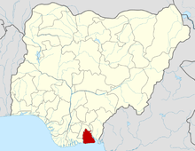 | |
History
Nsit Ubium Local Government Area was carved out of the then Etinan Local Government on May 3, 1989 with its headquarters at Ikot Edibon. In September 1991, the present Nsit Ubom Local Government Area was carved out leaving Nsit Ubium with its present two clans — Nsit and Ubium with a total of 64 villages. It is located at about 6 km East of Eket, Okobo, Nsit Ibom, Etinan, Ibesipko/Asutan and Nsit Atai Local Government Areas. shears common boundary with Nsit Ibom and Eket Local government It is well drained by the Qua Ibo River which has tributaries scattered in many locations in the area. Nsit Ubium covers a land mass of 242.942 sq kin; and located 6 km East of Eket. The topography of the Local Government is undulating with shallow depressions, dry valleys and few rivers, which lie far apart between the predominant plains. Marshes and swamps influenced by the Qua Iboe River traverse a large portion of the Local Government Area. Nsit Ubium is under Uyo Senatorial District.