O'Leary Peak
| O'Leary Peak | |
|---|---|
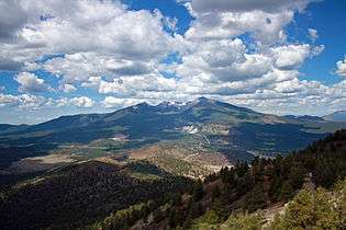
 O'Leary Peak (center) from the Bonito Lava Flow | |
| Highest point | |
| Elevation | 8,919 ft (2,719 m) NAVD 88[1] |
| Prominence | 1,778 ft (542 m) [2] |
| Coordinates | 35°24′05″N 111°31′35″W / 35.401462956°N 111.526498242°WCoordinates: 35°24′05″N 111°31′35″W / 35.401462956°N 111.526498242°W [1] |
| Geography | |
 O'Leary Peak
| |
| Location | Coconino County, Arizona, U.S. |
| Topo map | USGS O'Leary Peak |
| Geology | |
| Volcanic field | San Francisco volcanic field |
O'Leary Peak is an extinct Pleistocene lava dome volcano within the San Francisco volcanic field, north of Flagstaff, Arizona,[3] and to the northwest of Sunset Crater National Monument. A fire lookout tower was built on a subsidiary eastern peak. It has and elevation of 8,919 feet (2,719 m).[1]
 View of the San Francisco Peaks from O'Leary Lookout, 2009
References
- 1 2 3 "Oleary". NGS data sheet. U.S. National Geodetic Survey. Retrieved 2016-08-19.
- ↑ "O'Leary Peak, Arizona". Peakbagger.com. Retrieved 2014-02-08.
- ↑ Ulrich, George E; U.S. Geological Survey; U.S. Department of Energy; et al. Map showing geology, structure, and uranium deposits of the Flagstaff 1° x 2° quadrangle, Arizona. U.S. Geological Survey, Miscellaneous Investigations Series Map I-1446. OCLC 11553220.
External links
- "O'Leary Peak". Geographic Names Information System. United States Geological Survey.
- "O'Leary Peak Trail". Coconino National Forest.
- "O'Leary Peak". SummitPost.org.
This article is issued from Wikipedia - version of the 8/20/2016. The text is available under the Creative Commons Attribution/Share Alike but additional terms may apply for the media files.