Oregon Route 380
| ||||
|---|---|---|---|---|
 | ||||
| Route information | ||||
| Maintained by ODOT | ||||
| Length: | 55.49 mi[1] (89.30 km) | |||
| Existed: | 2002 – present | |||
| Major junctions | ||||
| West end: |
| |||
| East end: | Beaver Creek Bridge in Paulina | |||
| Highway system | ||||
| ||||

Oregon Route 380 (OR 380) is an Oregon state highway running from Prineville to Paulina. OR 380 is known as the Paulina Highway No. 380 (see Oregon highways and routes). It is 55.49 miles (89.30 km) long and runs east–west, entirely within Crook County. OR 380 was assigned to the Paulina Highway in 2002.
Route description
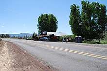
OR 380 in Post, OR
OR 380 begins at an intersection with U.S. Route 26 (US 26) at Prineville and heads east through Post to Paulina, where it ends at the Beaver Creek Bridge.[2]
History
OR 380 was established in 2002 as part of Oregon's project to assign route numbers to highways that previously were not assigned.
Major intersections
The entire route is in Crook County.
| Location | mi[1] | km | Destinations | Notes | |
|---|---|---|---|---|---|
| Prineville | 0.00 | 0.00 | Western terminus | ||
| Paulina | 55.49 | 89.30 | Paulina Suplee Road | Continuation beyond eastern terminus at Beaver Creek Bridge | |
| 1.000 mi = 1.609 km; 1.000 km = 0.621 mi | |||||
See also
 Oregon portal
 U.S. Roads portal
References
- 1 2 "Paulina Highway No. 380 - Straightline Chart" (PDF). Oregon Department of Transportation. January 2012. Retrieved July 25, 2014.
- ↑ Google (July 25, 2014). "Overview of OR 380" (Map). Google Maps. Google. Retrieved July 25, 2014.
- Oregon Department of Transportation, Descriptions of US and Oregon Routes, http://www.oregon.gov/ODOT/HWY/TRAFFIC/TEOS_Publications/PDF/Descriptions_of_US_and_Oregon_Routes.pdf, page 30.
This article is issued from Wikipedia - version of the 7/26/2014. The text is available under the Creative Commons Attribution/Share Alike but additional terms may apply for the media files.