Obira
For the town in Japan, see Obira, Hokkaidō.
 | |
| Geography | |
|---|---|
| Location | South East Asia |
| Coordinates | 1°30′S 127°45′E / 1.500°S 127.750°ECoordinates: 1°30′S 127°45′E / 1.500°S 127.750°E |
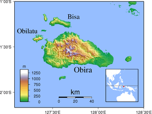
| Area | 2,542 km2 (981 sq mi) |
| Administration | |
|
Indonesia | |
| Demographics | |
| Population | 29,642 (2010) |
Obira (also called Utara or Obi) is the main island in the Obi Islands group, in Indonesia, south of the larger Halmahera in North Maluku. Its area is 2542 km².
The island is eponymous to the Obi Island Birdwing, an endemic species of butterfly.[1] Due to extensive logging on the island, which has reduced its habitat, the conservation of this species is a concern.
References
- ↑ Global Biodiversity Information Facility, record for Ornithoptera aesacus
This article is issued from Wikipedia - version of the 11/17/2016. The text is available under the Creative Commons Attribution/Share Alike but additional terms may apply for the media files.