Ocala Historic District
|
Ocala Historic District | |
|
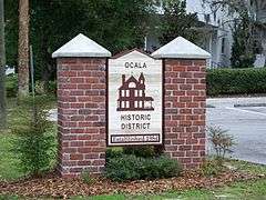
Western entrance to Ocala's Residential Historic District | |
  | |
| Location |
Ocala, Florida |
|---|---|
| Coordinates | 29°11′0″N 82°7′42″W / 29.18333°N 82.12833°WCoordinates: 29°11′0″N 82°7′42″W / 29.18333°N 82.12833°W |
| Area | 172 acres (0.70 km2) |
| Built | 1880-1930 |
| NRHP Reference # | 84000912[1] |
| Added to NRHP | January 12, 1984 |
| Wikimedia Commons has media related to Ocala Historic District. |
The Ocala Historic District is a U.S. Historic District (designated as such on January 12, 1984) located in Ocala, Florida. It encompasses 172 acres (0.70 km2), and is bounded by Broadway, Southeast 8th Street, Silver Springs Place, Southeast 3rd, 13th, and Watula Avenues. It contains 220 historic buildings.
References
- ↑ National Park Service (2010-07-09). "National Register Information System". National Register of Historic Places. National Park Service.
External links

This article is issued from Wikipedia - version of the 11/25/2016. The text is available under the Creative Commons Attribution/Share Alike but additional terms may apply for the media files.