Ogasawara, Tokyo
| Ogasawara Village 小笠原村 | ||
|---|---|---|
| Village | ||
| ||
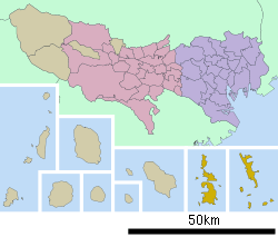 Location of Ogasawara Village in Tokyo Metropolis (Ogasawara Subprefecture) | ||
 Ogasawara Village Location in Japan | ||
| Coordinates: 26°59′N 142°13′E / 26.983°N 142.217°ECoordinates: 26°59′N 142°13′E / 26.983°N 142.217°E | ||
| Country | Japan | |
| Region | Kantō[1][2] | |
| Prefecture |
Tokyo Metropolis (Ogasawara Subprefecture) | |
| District | None | |
| Government | ||
| • Mayor | Kazuo Morishita | |
| Area | ||
| • Total | 104.41 km2 (40.31 sq mi) | |
| Population (January 2008) | ||
| • Total | 2,772 | |
| • Density | 26.5/km2 (69/sq mi) | |
| Symbols | ||
| • Tree | Screw pine | |
| • Flower | Munin Himetsubaki (Schima mertensiana) | |
| • Bird | Bonin white-eye | |
| Time zone | Japan Standard Time (UTC+9) | |
| City hall address |
Nishimachi, Chichi-jima, Ogasawara-mura, Tōkyō-to 100-2101 | |
| Website |
www | |

Ogasawara (小笠原村 Ogasawara-mura) is a village (rural municipality) in Ogasawara Subprefecture, Tokyo Metropolis, Japan, that governs the Bonin Islands, Volcano Islands and three remote islands (Nishinoshima, Minami Torishima and Okinotorishima).
Geography
The municipality consists of the following groups and single isolated islands:
- Bonin Islands (小笠原群島, Ogasawara Guntō) 73.00 km2
- Mukojima rettō (聟島列島) 6.57 km2
- Chichijima rettō (父島列島) 38.89 km2
- Hahajima rettō (母島列島) 27.54 km2
- Nishino shima (西之島, literally: Western Island, also: Rosario Island), a single isolated island west of Hahajima rettō and north of the Volcano Islands, 0.29 km2
- Volcano Islands (火山列島, Kazan-rettō) 29.71 km2
- Kita Iwojima (北硫黄島, Kita-Iōtō, literally: North Sulphur Island) 5.57 km2
- Iwojima (硫黄島, Iōtō, literally: Sulphur Island) 20.60 km2
- Minami Iwojima (南硫黄島, Minami-Iōtō, literally: South Sulphur Island) 3.54 km2
- Okinotorishima (沖ノ鳥島 or 沖鳥島, literally: Remote Bird Island) 0.01 km2
- Minamitorishima (南鳥島, literally: Southern Bird Island, also: Marcus Island) 1.40 km2
The southernmost (uninhabited) group is known as the Volcano Islands. 700 km further south is Okino Torishima, and 1,900 km further east is Minamitorishima.
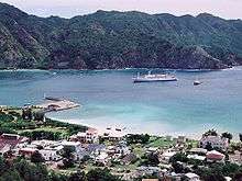
The population of the municipality resides on Chichi-jima (pop. about 2300) and Haha-jima (pop. about 500). The administration and village hall is located in the village of Omura on Chichi-jima. In addition, there is an air base with 400 soldiers on Iwojima of the Volcano Islands.
History
In 1940, five municipalities were created in the islands, which had been unincorporated before, two on Chichijima, two on Hahajima, and one on Iwojima[3]
- Ōmura (大村) on Chichijima
- Ōgimura-Fukurosawa (扇村袋沢村, -mura) on Chichijima
- Kitamura (北村) on Hahajima
- Okimura (沖村) on Hahajima
- Iōtō (硫黄島村, -mura) on Iwojima (Iōtō) (including all Volcano Islands)
Both villages of Kita Iwo Jima became part of newly created Iwojima municipality in 1940:
- Ishinomura (east)
- Nishimura (west)
Education
Ogasawara Village operates the island's public elementary and junior high schools.
Tokyo Metropolitan Government Board of Education operates Ogasawara High School on Chichi-jima.
See also
References
- ↑ Japanese Wikipedia article of ja:関東地方#位置, retrieved on October 16, 2008.
- ↑ 伊豆・小笠原諸島における 情報通信インフラ整備状況の調査 Archived October 24, 2007, at the Wayback Machine. (Survey on improvement conditions of telecommunication infrastructures in Izu-Ogasawara Islands), Kantō Bureau of Telecommunications, retrieved on October 16, 2008.
- ↑ "Historical Development" (in Japanese).
External links
- Ogasawara Village (Japanese)
- The Bonin (Ogasawara) Islands Language and Culture Site
- Ogasawara Channel (Japanese)
- "Ogasawara subtropical moist forests". Terrestrial Ecoregions. World Wildlife Fund.
- National Archives of Japan: The faked map of 1752 mentioned in Hiroyuki Tanaka's 1998 article.
- Tokyo Metropolitan Government, Ogasawara-mura: maps/photos
| Sovereign states |
| .svg.png) | |||||||||
|---|---|---|---|---|---|---|---|---|---|---|---|
Dependencies and other territories |
| ||||||||||