Ogo Mountains
| Ogo Mountains | |
|---|---|
 | |
| Highest point | |
| Peak | Shimbiris |
| Elevation | 2,450 m (8,040 ft) |
| Geography | |
 Map of Ogo Mountains | |
| Country | Somalia |
| State/Province | Sanaag Togdheer |
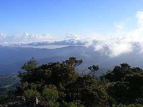
The Ogo Mountains, also known as the Galgodon Highlands, are a mountain range in Somalia. They cross the Sanaag and Togdheer regions. With a mean peak height of 2,450 metres (8,038 ft), the ecology of this landform is semi-desert.
Ecology
Due to the Ogo Mountains' elevated, highland location in northern Somalia, the range has an unexpectedly temperate climate. The mountains also catch the precipitation of the Indian Ocean's monsoon winds, resulting in a rainy season that lasts from June until mid-September.
Climate
The average annual temperature in the Ogo Mountains is 20 to 26 °C (68 to 79 °F). Precipitation reaches a maximum in March, with a minimum of rainfall in August. The average annual precipitation around 500-700 mm.
| Climate data for Gudaado (10°44'03.3"N 47°13'56.6"E) | |||||||||||||
|---|---|---|---|---|---|---|---|---|---|---|---|---|---|
| Month | Jan | Feb | Mar | Apr | May | Jun | Jul | Aug | Sep | Oct | Nov | Dec | Year |
| Average high °C (°F) | 19.5 (67.1) |
21.4 (70.5) |
21.7 (71.1) |
22.3 (72.1) |
22.8 (73) |
22.0 (71.6) |
21.6 (70.9) |
21.9 (71.4) |
21.4 (70.5) |
21.0 (69.8) |
19.9 (67.8) |
18.7 (65.7) |
21.18 (70.12) |
| Daily mean °C (°F) | 11.6 (52.9) |
13.3 (55.9) |
14.1 (57.4) |
15.4 (59.7) |
16.5 (61.7) |
16.6 (61.9) |
16.7 (62.1) |
16.8 (62.2) |
15.8 (60.4) |
14.1 (57.4) |
12.5 (54.5) |
11.4 (52.5) |
14.57 (58.22) |
| Average low °C (°F) | 3.7 (38.7) |
5.2 (41.4) |
6.5 (43.7) |
8.6 (47.5) |
10.2 (50.4) |
11.3 (52.3) |
11.9 (53.4) |
11.7 (53.1) |
10.3 (50.5) |
7.2 (45) |
5.2 (41.4) |
4.1 (39.4) |
7.99 (46.4) |
| Average rainfall mm (inches) | 18 (0.71) |
17 (0.67) |
39 (1.54) |
53 (2.09) |
84 (3.31) |
56 (2.2) |
20 (0.79) |
55 (2.17) |
103 (4.06) |
16 (0.63) |
17 (0.67) |
4 (0.16) |
482 (19) |
| Source: Climate Data [1] | |||||||||||||
References
- ↑ Climate Data. "Climate Guadaado, Somalia". Climate Data. Retrieved 2012-04-09.
- "Galgodon Highlands". Encyclopaedia Britannica. Retrieved 25 June 2013.
This article is issued from Wikipedia - version of the 8/22/2016. The text is available under the Creative Commons Attribution/Share Alike but additional terms may apply for the media files.