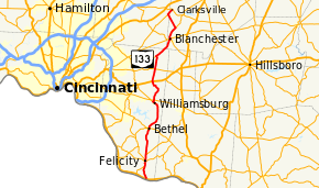
Ohio State Route 133
| ||||
|---|---|---|---|---|
 | ||||
| Route information | ||||
| Maintained by ODOT | ||||
| Length: | 49.40 mi[1] (79.50 km) | |||
| Existed: | 1923[2][3] – present | |||
| Major junctions | ||||
| South end: |
| |||
| ||||
| North end: |
| |||
| Location | ||||
| Counties: | Clermont, Warren, Clinton | |||
| Highway system | ||||
| ||||

State Route 133 (SR 133) is a north–south state highway in the southwestern portion of the U.S. state of Ohio. Its southern terminus is at its interchange with U.S. Route 52 near Felicity and its northern terminus is at its interchange with SR 350 in Clarksville.
History
SR 133 was commissioned in 1923, between Chilo and Bethel. On the route of current SR 222 from Chilo to Felicity and its current route between Felicity and Bethel.[2][3] In 1926 the highway was extended north to Owensville, passing through Williamsburg.[4][5] The route was moved onto its current route south of Felicity in 1930, switching routes with SR 222. In that same year the route was extended north to Blanchester.[6][7] In 1932 the highway was extended north to Clarksville.[8][9]
Major intersections
| County | Location | mi[1] | km | Destinations | Notes | |||
|---|---|---|---|---|---|---|---|---|
| Clermont | Franklin Township | 0.00 | 0.00 | Southern terminus of SR 133 | ||||
| 3.27 | 5.26 | Southern end of SR 222 concurrency | ||||||
| Felicity | 4.62 | 7.44 | Northern terminus of SR 222; southern end of SR 756 | |||||
| 4.68 | 7.53 | Northern end of SR 756 concurrency | ||||||
| Franklin Township | 6.50 | 10.46 | Southern terminus of SR 744 | |||||
| Bethel | 13.40 | 21.57 | ||||||
| Williamsburg | 21.12 | 33.99 | Southern end of SR 276 concurrency; southern terminus of SR 276 | |||||
| 21.63 | 34.81 | Northern end of SR 276 concurrency | ||||||
| 22.12 | 35.60 | |||||||
| Jackson Township | 28.00 | 45.06 | ||||||
| Wayne Township | 31.16 | 50.15 | ||||||
| 34.57 | 55.64 | Northern terminus of SR 727 | ||||||
| Warren |
No major junctions | |||||||
| Clinton | Blanchester | 40.38 | 64.99 | Southern end of SR 123 concurrency | ||||
| 40.50 | 65.18 | Northern end of SR 123 concurrency | ||||||
| Marion Township | 43.75 | 70.41 | Southern terminus of SR 730 | |||||
| Warren | Washington Township | 47.71 | 76.78 | Southern end of SR 132 concurrency | ||||
| Clinton | Clarksville | 49.40 | 79.50 | Northern end of SR 132 concurrency; northern terminus of SR 132; northern terminus of SR 133 | ||||
1.000 mi = 1.609 km; 1.000 km = 0.621 mi
| ||||||||
References
- 1 2 Ohio Department of Transportation. "Technical Services Straight Line Diagrams". Retrieved April 30, 2010.
- 1 2 Ohio Department of Highways and Public Works (April 1922). Map of Ohio State Highways (MrSID) (Map). Columbus: Ohio Department of Highways and Public Works. Retrieved October 13, 2013.
- 1 2 Ohio Department of Highways and Public Works (July 1923). Map of Ohio Showing State Routes (MrSID) (Map). 1:760,320. Columbus: Ohio Department of Highways and Public Works. Retrieved October 13, 2013.
- ↑ Ohio Department of Highways and Public Works (August 1925). Map of Ohio Showing State Routes (MrSID) (Map). 1:760,320. Columbus: Ohio Department of Highways and Public Works. OCLC 5673562. Retrieved October 13, 2013.
- ↑ Ohio Department of Highways and Public Works (August 1, 1926). Map of Ohio Showing State Routes (MrSID) (Map). 1:760,320. Columbus: Ohio Department of Highways and Public Works. OCLC 5673562. Retrieved October 13, 2013.
- ↑ Ohio Department of Highways (August 15, 1929). Map of Ohio Showing State Routes (MrSID) (Map). 1:760,320. Columbus: Ohio Department of Highways. OCLC 5673562, 7438560. Retrieved October 13, 2013.
- ↑ Ohio Department of Highways (1930). Map of Ohio Showing State Routes (MrSID) (Map). 1:760,320. Columbus: Ohio Department of Highways. OCLC 5673562, 7237073. Retrieved October 13, 2013.
- ↑ Ohio Department of Highways (1931). Map of Ohio Showing State Routes (MrSID) (Map). 1:760,320. Columbus: Ohio Department of Highways. OCLC 5673562, 7231737. Retrieved October 13, 2013.
- ↑ Ohio Department of Highways (1932). Map of Ohio Showing State Routes (MrSID) (Map). 1:760,320. Columbus: Ohio Department of Highways. OCLC 5673562, 7231704. Retrieved October 13, 2013.